Onamia, Minnesota
| Onamia, Minnesota | |
|---|---|
| City | |
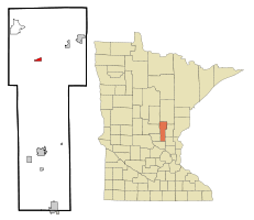 Location of Onamia within Mille Lacs County, Minnesota | |
| Coordinates: 46°4′12″N 93°40′6″W / 46.07000°N 93.66833°W | |
| Country | United States |
| State | Minnesota |
| County | Mille Lacs |
| Area[1] | |
| • Total | 0.97 sq mi (2.51 km2) |
| • Land | 0.96 sq mi (2.49 km2) |
| • Water | 0.01 sq mi (0.03 km2) |
| Elevation | 1,263 ft (385 m) |
| Population (2010)[2] | |
| • Total | 878 |
| • Estimate (2012[3]) | 870 |
| • Density | 914.6/sq mi (353.1/km2) |
| Time zone | Central (CST) (UTC-6) |
| • Summer (DST) | CDT (UTC-5) |
| ZIP code | 56359 |
| Area code(s) | 320 |
| FIPS code | 27-48310[4] |
| GNIS feature ID | 0648967[5] |
Onamia (/oʊˈneɪmiːə/ oh-NAYM-ee-ə) is a city in Mille Lacs County, Minnesota, United States. The population was 878 at the 2010 census.[6] U.S. Highway 169 and Minnesota State Highway 27 are the main routes in the community.
History
Originally, the city of Onamia was organized from the merger of two communities, Village of Onamia (Ojibwe: Onamanii-zaaga'iganiing) and the Village of Ericksonville (Ojibwe: Gibaakwa'igaansing). Onamia is named after Lake Onamia, of which "Onamia" is derived from the Ojibwe word onaman meaning "red ochre", or locally as "vermilion". Ericksonville was incorporated in 1898. Onamia was incorporated in 1908.
Geography
According to the United States Census Bureau, the city has a total area of 0.97 square miles (2.51 km2), of which 0.96 square miles (2.49 km2) is land and 0.01 square miles (0.03 km2) is water.[1] Onamia is three miles south of Mille Lacs Lake.
Demographics
| Historical population | |||
|---|---|---|---|
| Census | Pop. | %± | |
| 1910 | 314 | — | |
| 1920 | 416 | 32.5% | |
| 1930 | 514 | 23.6% | |
| 1940 | 619 | 20.4% | |
| 1950 | 704 | 13.7% | |
| 1960 | 645 | −8.4% | |
| 1970 | 670 | 3.9% | |
| 1980 | 691 | 3.1% | |
| 1990 | 676 | −2.2% | |
| 2000 | 847 | 25.3% | |
| 2010 | 878 | 3.7% | |
| Est. 2015 | 864 | [7] | −1.6% |
| U.S. Decennial Census | |||
2010 census
As of the census[2] of 2010, there were 878 people, 349 households, and 167 families residing in the city. The population density was 914.6 inhabitants per square mile (353.1/km2). There were 398 housing units at an average density of 414.6 per square mile (160.1/km2). The racial makeup of the city was 83.0% White, 2.3% African American, 9.9% Native American, 0.7% Asian, 0.3% from other races, and 3.8% from two or more races. Hispanic or Latino of any race were 1.7% of the population.
There were 349 households of which 26.9% had children under the age of 18 living with them, 26.9% were married couples living together, 14.9% had a female householder with no husband present, 6.0% had a male householder with no wife present, and 52.1% were non-families. 46.4% of all households were made up of individuals and 26.7% had someone living alone who was 65 years of age or older. The average household size was 2.07 and the average family size was 2.84.
The median age in the city was 41.7 years. 28% of residents were under the age of 18; 9.4% were between the ages of 18 and 24; 15.3% were from 25 to 44; 22.7% were from 45 to 64; and 24.7% were 65 years of age or older. The gender makeup of the city was 53.4% male and 46.6% female.
2000 census
As of the census[4] of 2000, there were 847 people, 318 households, and 171 families residing in the city. The population density was 938.3 people per square mile (363.4/km²). There were 355 housing units at an average density of 393.3 per square mile (152.3/km²). The racial makeup of the city was 90.20% White, 0.94% African American, 6.49% Native American, 0.24% from other races, and 2.13% from two or more races. Hispanic or Latino of any race were 1.18% of the population.
There were 318 households out of which 26.4% had children under the age of 18 living with them, 38.1% were married couples living together, 12.3% had a female householder with no husband present, and 46.2% were non-families. 42.8% of all households were made up of individuals and 23.9% had someone living alone who was 65 years of age or older. The average household size was 2.16 and the average family size was 2.98.
In the city the population was spread out with 28.5% under the age of 18, 7.8% from 18 to 24, 18.8% from 25 to 44, 18.8% from 45 to 64, and 26.2% who were 65 years of age or older. The median age was 41 years. For every 100 females there were 90.8 males. For every 100 females age 18 and over, there were 77.7 males.
The median income for a household in the city was $21,250, and the median income for a family was $32,500. Males had a median income of $31,000 versus $19,375 for females. The per capita income for the city was $12,857. About 11.9% of families and 14.6% of the population were below the poverty line, including 18.0% of those under age 18 and 7.3% of those age 65 or over.
Arts and culture
Onamia is the town nearest to Camp Onomia, a Lutheran summer camp.
Festival
For one weekend during June, the town holds the Onamia Days festival that includes carnival-type rides, and a parade on Sunday at 2pm. The parade is known to have many classic cars from local collectors, and is for all ages.
References
- 1 2 "US Gazetteer files 2010". United States Census Bureau. Retrieved 2012-11-13.
- 1 2 "American FactFinder". United States Census Bureau. Retrieved 2012-11-13.
- ↑ "Population Estimates". United States Census Bureau. Retrieved 2013-05-28.
- 1 2 "American FactFinder". United States Census Bureau. Retrieved 2008-01-31.
- ↑ "US Board on Geographic Names". United States Geological Survey. 2007-10-25. Retrieved 2008-01-31.
- ↑ "2010 Census Redistricting Data (Public Law 94-171) Summary File". American FactFinder. U.S. Census Bureau, 2010 Census. Retrieved 23 April 2011.
- ↑ "Annual Estimates of the Resident Population for Incorporated Places: April 1, 2010 to July 1, 2015". Retrieved July 2, 2016.
External links
- Mille Lacs Messenger - newspaper site serving Onamia, Minnesota
- Onamia Area Website - Link
- Mille Lacs Area Tourism Council website - resource for all your Mille Lacs Area information
Coordinates: 46°04′14″N 93°40′04″W / 46.07056°N 93.66778°W
Municipalities and communities of Mille Lacs County, Minnesota, United States | ||
|---|---|---|
| Cities |  | |
| Townships | ||
| CDP | ||
| Unincorporated communities | ||
| Indian reservation | ||
| Footnotes | ‡This populated place also has portions in an adjacent county or counties | |