Ojocaliente, Zacatecas
Ojocaliente is a medium-sized town in the Mexican state of Zacatecas. It is similar in appearance with Fresnillo, also having bright-colored houses and a park to serve as a sort of central ornament. It is called "Ojocaliente" (translation: hot eye) because there previously were small "ojos" of water ("Ojo" meaning "pond" or "pool").The town of Ojocaliente, Zacatecas was founded in 1620 and its first name was "Real Villa de Sacramento and Ojocaliente Mina de Bastidas." The name of Ojocaliente was given because of its hot springs and mineral veins that were exploited in the hills of Santiago.
Population
The population of Ojocaliente is approximately 150 thousand people.
Geography
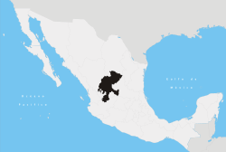
Located at 2040 meters above sea level. Ojocaliente Township has a land area of 685.775 Km2. Ojocaliente is located south-east of the state of Zacatecas.
The population is served by all means of communication and has all the services: services of electricity, potable water, sewage, telephone, telegraph service and many of its streets are paved, etc.
Transportation
The center of the population is cut in half by the Pan American Highway # 45 Mexico- Ciudad Juarez.
The population of Ojocaliente, Zacatecas. Guadalupe bordered on the north, south to San Pedro and Luis Moya, the Villa Gonzalez Ortega east and west by Genaro Codina.
8 km west is the railway station of the population of Berriosabal and south to the railway station 10 km from the town of Aguascalientes Adames.
The airport is 55 km north of the population and only 50 minutes from time.
Ojocaliente Township, Zacatecas has 115 Rancherias surrounding population and make up the municipality.
Agriculture
Different crops such as beans, maize, barley, potatoes, etc. are commonly produced in Ojocaliente. There are also large extensions of land, with groves of grape and its product is imported wine processing plants and plant in Aguascalientes in wine from the same population of Ojocaliente, Zacatecas.
There is also the region with plantings of prickly pear (Castañeda Engineers property) which has well water to irrigate it, the tuna of this place is exported to the United States, after being fully processed (cleaned, waxed wrapped in paper and shipped perfectly packed).
Education
In the village kindergartens have 5: The K-18 March (this was the first kindergarten in the village there was), the avejitas kindergarten, kindergarten DIF, the colony Pamanes kindergarten and kindergarten for school.
Ojocaliente has six primary schools: school Jesus Gonzalez Ortega, Esteban S. School Castorena, school Castorena Delfina Acosta, Aurelio school Pamanes Escobedo, Guadalupe Acosta school and school Belausaran Rafael Ramirez.
It has the high school General Ignacio Zaragoza.
It has a secondary technique.
There is a telesecundaria.
There is a Centro de Bachilletaro Tecnológico Agropecuario.
One school (school graduates). It is affiliated to the Universidad Autonoma de Zacatecas.
Religion
In the religious row, there is the cathedral which is located in the center of town, next is its beautiful garden and in the middle of this her kiosk.
In addition there are 8 chapels in different colonies of the population: Capilla de la Virgen del Carmen. (Located in Colonia del Carmen), Chapel of Jesus of Nazareth in the district of Jeruzalen, chapel master of forgiveness in the neighborhood of San Pedro, chapel master of the afflicted in the neighborhood of Turicato, martell chapel in the colony of the same name, an evangelical church in the neighborhood of San Pedro and a Mormon Temple (by the way very nice).
Farmers' pilgrimage.
Coordinates: 22°34′00″N 102°15′00″W / 22.5666666767°N 102.25000001°W
Zacatecas (capital) | ||
| Municipalities and (municipal seats) |
|  |