Oakford, Devon
Coordinates: 50°58′54″N 3°33′14″W / 50.981600°N 3.553775°W
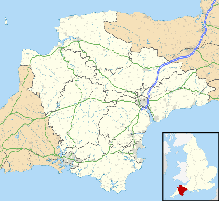
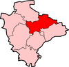
Oakford is a village and civil parish in the Mid Devon district of Devon, England. It is located three miles south west of Bampton and eight miles north north west of Tiverton. Oakford is located near the river Exe.
In 1870, John Marius Wilson's Imperial Gazetteer of England and Wales described Oakford like this:
- "OAKFORD, a village and a parish in Tiverton district, Devon. The village stands on a bold acclivity, adjacent to a tributary of the river Exe, 2 miles S of the boundary with Somerset, 3 W S W of Bampton, and 6½ N N W of Tiverton r. station; is large and straggling; and has a post-office under Tiverton. The parish comprises 5, 464acres."[1]
Population
It had a population of 358 according to the 2011 census with 185 being Males and 173 being Female.[2]

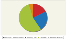
The 1831 census provides information, down to parish-level, on the occupations of males aged over 20 using nine categories. Here we reorganise this information to provide a crude measure of social status, based more on contemporary ideas than on modern definitions of social class: "middling sorts" combines small farmers not employing labourers with both masters and skilled workers in urban manufacturing and handicrafts.[3]
According to the 2011 census, 32% of those who are economically active in Oakford are self-employed; this is nearly twice the district statistics and over 3 times higher than the country's average.[4]

History
Oakford church (St. Peter) dominates the village from an eminence. The porch, nave, cancel and vestry were rebuilt in 1838-9, except for the 15th century tower, with a spacious nave and short chancel. The tower houses eight bells, said to have exceptional tone, cast by Mears of London in 1825 and given to the church by the then rector, the Rev James Parkin. He also presented the organ, built by J R Mortimore of Tiverton, in 1841.[5] Spurway Barton lies remote above a wooded combe and was a Domesday manor. The Spurways were already settled here in 1244 and continued to own it until recently. Other farms mentioned in Domesday are Bickham Barton, Mildon, Woodburn and East and West Tapps.[6]

Oakford is located within Mid Devon local authority area. Historically it formed part of Witheridge Hundred. It falls within Tiverton Deanery for ecclesiastical purposes. The Deaneries are used to arrange the typescript Church Notes of B.F.Cresswell which are held in the Westcountry Studies Library. The population was 480 in 1801 484 in 1901 .
Education
There is no school in Oakford, however there is an Educational foundation in place. The Pyncombe Educational Foundation assists pupils in the advancement of their education and otherwise promoting education of boys and girls in the beneficial area. The Foundation awards grants of £150 to help with purchase of books and equipment to any young person who lives in Oakford, or who has lived here within the last year, and is continuing with further education. The award is made in September and is given directly to the person concerned.[7]
The fund was set up in 1998 through the amalgamation of several Oakford Village Charities. The nearest primary school to Oakford is Bampton Church of England School; situated in Bampton, accommodating ages 3–11. This school is Co-Ed. There are 8 primary schools within 6 miles of Oakford.[8] Oakford has 3 types of secondary school within 7 miles. Acorn school is the closest being located in South Molten (special school), Tiverton High School is the second nearest (Maintained school) and Blundells school is the nearest Independent School. These secondary schools all cater for ages 11–16 with Blundells catering up to age 18 as well.[9]
Housing
According to the 2011 census, 49.1% of accommodations in Oakford are owned outright with 32.9% of accommodation being owned with a mortgage or loan; these figure are higher than both regional and country statistics.[10] There are 161 households.

References
- ↑ Wilson, John Marius (1870–72). Gazetteer of England and Wales. Edinburgh: A. Fullerton & Co. Retrieved 27 January 2015.
- ↑ "Oakford (Parish): Key figures for 2011 census: Key Statistics". Neighbourhood Statistics. Office for National Statistics. Retrieved 27 January 2015.
- ↑ GB Historical GIS / University of Portsmouth, Oakford AP/CP through time | Social Structure Statistics | Social Status, based on 1831 occupational statistics, A Vision of Britain through Time. URL: http://www.visionofbritain.org.uk/unit/10166238/cube/SOC1831 Date accessed: 24th February 2015
- ↑ "Oakford (Parish): Key figures for 2011 census: Key Statistics". Neighbourhood Statistics. Office for National Statistics. 20 April
- ↑ Oakford parish, oakford church,http://www.middevon.gov.uk/oakford/index.aspx?articleid=5578 20 April 2015
- ↑ Devon County Council, Oakford, http://www.devon.gov.uk/historicoakford, 12 April 2015
- ↑ http://www.middevon.gov.uk/oakford/index.aspx?articleid=9107
- ↑ Primary schools near Oakford http://home.rm.com/SchoolFinder/ShowSchools.aspx?l=Oakford,Devon&t=pri
- ↑ Secondary schools near Oakford http://home.rm.com/SchoolFinder/ShowSchools.aspx?l=Oakford,Devon&t=sec
- ↑ "Oakford (Parish): Key figures for 2011 census: Key Statistics". Neighbourhood Statistics. Office for National Statistics. 20 April
External links
| Wikimedia Commons has media related to Oakford, Devon. |
- GENUKI(tm) page
- Some details
- Map sources for Oakford, Devon
 | Towns
| |