Clayhanger, Devon
.jpg)
Coordinates: 50°59′54″N 3°23′43″W / 50.998245°N 3.39514°W
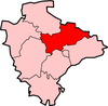
Clayhanger is a hamlet in the Mid Devon district of Devon, England.[1][2] It is close to the site of a Roman fort east of the Upper Exe Valley (Cudmore Farm).
References
- ↑ Ordnance Survey: Landranger map sheet 181 Minehead & Brendon Hills (Dulverton & Tiverton) (Map). Ordnance Survey. 2009. ISBN 9780319231814.
- ↑ "Ordnance Survey: 1:50,000 Scale Gazetteer" (csv (download)). www.ordnancesurvey.co.uk. Ordnance Survey. 1 January 2016. Retrieved 18 February 2016.
 | Towns
| |
This article is issued from Wikipedia - version of the 10/6/2016. The text is available under the Creative Commons Attribution/Share Alike but additional terms may apply for the media files.