Norwood, Michigan
| Norwood, Michigan | |
|---|---|
| Census-designated place | |
 Norwood Location within the state of Michigan | |
| Coordinates: 45°13′0″N 85°22′53″W / 45.21667°N 85.38139°WCoordinates: 45°13′0″N 85°22′53″W / 45.21667°N 85.38139°W | |
| Country | United States |
| State | Michigan |
| Counties | Charlevoix |
| Township | Norwood |
| Area | |
| • Total | 2.03 sq mi (5.26 km2) |
| • Land | 2.03 sq mi (5.26 km2) |
| • Water | 0 sq mi (0 km2) |
| Elevation | 700 ft (200 m) |
| Population (2010) | |
| • Total | 142 |
| • Density | 70/sq mi (27.0/km2) |
| Time zone | Eastern (EST) (UTC-5) |
| • Summer (DST) | EDT (UTC-4) |
| Area code(s) | 231 |
| FIPS code | 26-59320 |
| GNIS feature ID | 0633765[1] |
Norwood is an unincorporated community and census-designated place in Charlevoix County in the U.S. state of Michigan. As of the 2010 census it had a population of 142.[2]
Geography
Norwood is located in western Charlevoix County in the southwest corner of Norwood Township, along the shore of Lake Michigan. It is bordered to the south by Banks Township in Antrim County. It about 1.5 miles (2.4 km) west of U.S. Route 31 by either Norwood Road or Gennett Road. Charlevoix, the county seat, is 10 miles (16 km) to the northeast, and Elk Rapids is 24 miles (39 km) to the south.
According to the U.S. Census Bureau, the Norwood CDP has a total area of 2.03 square miles (5.26 km2), all of it land.[2]
References
- ↑ U.S. Geological Survey Geographic Names Information System: Norwood, Michigan
- 1 2 "Geographic Identifiers: 2010 Demographic Profile Data (G001): Norwood CDP, Michigan". U.S. Census Bureau, American Factfinder. Retrieved September 5, 2014.
Municipalities and communities of Charlevoix County, Michigan, United States | ||
|---|---|---|
| Cities | 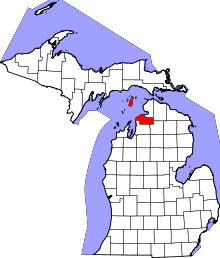 | |
| Village | ||
| Townships | ||
| CDPs | ||
This article is issued from Wikipedia - version of the 11/15/2014. The text is available under the Creative Commons Attribution/Share Alike but additional terms may apply for the media files.