North Brother
- For the mountain in Australia, see Three Brothers, New South Wales. For various islands of that name, see North Brother Island.
| North Brother | |
|---|---|
 | |
| Highest point | |
| Elevation | 4,150 ft (1,260 m) |
| Prominence | 1,243 ft (379 m) [1] |
| Listing | New England 4000 footers |
| Coordinates | 45°57′26″N 68°59′07″W / 45.957333°N 68.985333°WCoordinates: 45°57′26″N 68°59′07″W / 45.957333°N 68.985333°W [2] |
| Geography | |
 North Brother | |
| Topo map | USGS Mount Katahdin |
| Climbing | |
| Easiest route | Hiking trail |
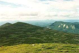
North Brother is a mountain located in Baxter State Park, Piscataquis County, Maine.[3] North Brother is flanked to the northeast by Fort Mountain, and to the southwest by South Brother; collectively the two are called "The Brothers."
The south and east sides of North Brother drains into a swampy area called "The Klondike", then into Wassataquoik Stream, the East Branch of the Penobscot River, and into Penobscot Bay. The north and west sides of North Brother drain into Little Nesowadnehunk Stream, Nesowadnehunk Stream, and the West Branch of the Penobscot River.
The Appalachian Trail, a 2,170 mi (3,490 km) National Scenic Trail from Georgia to Maine, reaches its northern terminus, on the summit of Mount Katahdin, 5 mi (8.0 km) to the southeast of The Brothers.