Middle Carter Mountain
| Middle Carter Mountain | |
|---|---|
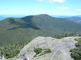 Middle Carter Mountain (center) seen from Mt. Hight | |
| Highest point | |
| Elevation | 4600+ ft (1402+ m) [1] |
| Prominence | 700 ft (210 m) [1] |
| Listing | White Mountain 4000-footers |
| Coordinates | 44°18′11″N 71°10′02″W / 44.3031199°N 71.1672964°WCoordinates: 44°18′11″N 71°10′02″W / 44.3031199°N 71.1672964°W [2] |
| Geography | |
| Location | Coös County, New Hampshire, U.S. |
| Parent range | Carter-Moriah Range |
| Topo map | USGS Carter Dome |
Middle Carter Mountain is a mountain located in Coos County, New Hampshire. The mountain is part of the Carter-Moriah Range of the White Mountains, which runs along the northern east side of Pinkham Notch. Middle Carter is flanked to the north by North Carter Mountain, and to the southwest by South Carter Mountain. The summit of Middle Carter is wooded, but there are views from the ridgecrest not far from the summit.[3]
See also
References
- 1 2 "Middle Carter Mountain, New Hampshire". Peakbagger.com. Retrieved 2013-02-02.
- ↑ "Middle Carter Mountain". Geographic Names Information System. United States Geological Survey. Retrieved 2013-02-02.
- ↑ "Middle Carter". HikeTheWhites.com. Retrieved 2013-02-02.
External links
- "Carter Mountain, Middle and South". SummitPost.org.
- "Hiking Middle Carter Mountain". Appalachian Mountain Club.
This article is issued from Wikipedia - version of the 12/18/2015. The text is available under the Creative Commons Attribution/Share Alike but additional terms may apply for the media files.