New Jersey Route 90
| ||||
|---|---|---|---|---|
 | ||||
| Route information | ||||
| Maintained by DRPA and NJDOT | ||||
| Length: | 3.22 mi[1] (5.18 km) | |||
| Existed: | 1965[2] – present | |||
| Major junctions | ||||
| West end: | Betsy Ross Bridge in Pennsauken | |||
|
| ||||
| East end: |
| |||
| Location | ||||
| Counties: | Camden, Burlington | |||
| Highway system | ||||
| ||||

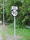
Route 90 is a 3.22-mile (5.18 km) state highway in New Jersey in the United States (U.S.). The western terminus is at the Betsy Ross Bridge over the Delaware River in Pennsauken Township, Camden County, where the road continues into Philadelphia, Pennsylvania as an unnumbered road that provides access to Interstate 95. The eastern terminus is an interchange with Route 73 in Cinnaminson Township, Burlington County. It is a four-to six-lane freeway its entire length, interchanging with U.S. Route 130 and Camden County Route 644.
Route 90 was first proposed in 1964 a year after plans were made to build the Betsy Ross Bridge and was legislated in 1965 to run from the bridge to Route 73. The portion of the route between the Betsy Ross Bridge and U.S. Route 130 was opened in 1976 while the portion from U.S. Route 130 to Route 73 opened in 1988. When first proposed, Route 90 was planned to extend farther south to Route 73 in Mount Laurel, intersecting Interstate 295 and the New Jersey Turnpike. There were other proposals that would have taken the freeway farther south to a planned Route 38 freeway, a planned U.S. Route 30 freeway in Berlin, and possibly the Atlantic City Expressway. However, financial and environmental obstacles prevented any southern extension of Route 90. Across the Delaware River in Philadelphia, a freeway which was to be called the Pulaski Expressway and be designated Pennsylvania Route 90 was to have run from Interstate 95 northwest to U.S. Route 1. This freeway was not built either due to opposition from residents and financial limitations.
Route description
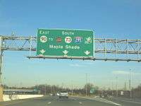
Route 90 begins at the Pennsylvania-New Jersey border on the Betsy Ross Bridge over the Delaware River, where the road continues into Philadelphia as an unnumbered freeway that heads to an interchange with Interstate 95.[1][3] Signs for the interchange along Interstate 95 refer to New Jersey Route 90.[4] From the Betsy Ross Bridge, Route 90 heads to the southeast into Pennsauken Township, Camden County as a six-lane, 45 mph (72 km/h) freeway maintained by the Delaware River Port Authority, passing over residential areas as well as County Route 543 (River Road) and then featuring a toll plaza in the westbound direction.[1][3] Route 90 passes over County Route 615 (Union Avenue) before coming to an interchange with U.S. Route 130, where maintenance is transferred to the New Jersey Department of Transportation. From here, the speed limit is increased to 50 mph (80 km/h). Shortly past the U.S. Route 130 interchange, the freeway narrows to four lanes before coming to a partial interchange with County Route 644 (Haddonfield Road), where there is a westbound on-ramp and an eastbound off-ramp. The route crosses into Cinnaminson Township, Burlington County and passes over the Pennsauken Creek. A short distance later, the Route 90 freeway merges into Route 73.[1]
History

Plans for the Route 90 freeway were first made in 1964, a year after the Betsy Ross Bridge over the Delaware River was proposed.[5] In 1965, Route 90 was legislated to run from the proposed bridge in Pennsauken east to Route 73.[2] In 1969, construction began on the Betsy Ross Bridge and its approach roads. A 1970 proposal to include the planned Route 90 freeway as a part of the Interstate Highway System was denied.[6] The Betsy Ross Bridge itself was finished in 1974, but did not open to traffic until April 30, 1976 due to controversies concerning the approach roads. At this time, Route 90 was completed between the Betsy Ross Bridge and U.S. Route 130. In March 1986, construction began on Route 90 between U.S. Route 130 and Route 73 in Cinnaminson. This section of the route, which cost $23 million ($40 million today), was opened on October 25, 1988.[7]
Originally, the Route 90 was intended to be a much longer freeway than it is today. When first proposed, it was to extend to Interstate 295, the New Jersey Turnpike and Route 73 in Mount Laurel. There were two proposed routes of this freeway. The first proposal would have run south of Route 73 through built-up areas of Cherry Hill, Maple Shade, and Mount Laurel, along the South Branch of the Pennsauken Creek. Due to the route of this proposal, it was dropped in favor of a more northerly route that ran to the north of Route 73 through less developed areas.This freeway would have cost $42 million ($180 million today) and was to be completed in 1975. There were plans to extend the freeway further south than Route 73 in Mount Laurel. In 1966, a proposal was made for Route 90 to run south to a proposed Route 38 freeway that was to run from Camden to Monmouth County.[8] Another proposal in 1969 called for a $14 million ($90 million today) extension of Route 90 south to a proposed U.S. Route 30 freeway in Berlin and possibly the Atlantic City Expressway. Due to financial limitations and feared environmental impacts, the southern extension of Route 90 to Mount Laurel was canceled by 1980.[9]
Across the Delaware River in Pennsylvania, there were plans of extending the freeway northwest from the Interstate 95 interchange. This limited access highway, which was to be called the Pulaski Expressway and be designated Pennsylvania Route 90, was to parallel the Frankford Creek and Tacony Creek and connect with U.S. Route 1, which also was to be a limited access freeway.[10] This proposed freeway, which was to cost from $125 to $150 million ($300 to $400 million today) and be completed in 1981, was canceled by 1980 due to community opposition and financial troubles.[11] Vestiges of this extension can be seen from Interstate 95 in the form of stub ramps and the mainline coming to an abrupt end as a barricaded bridge.[3]
Exit list
All exits are unnumbered.
| County | Location | mi[1] | km | Destinations | Notes |
|---|---|---|---|---|---|
| Philadelphia | Philadelphia | 0.00 | 0.00 | To exit 26 on I-95 | |
| Delaware River | Betsy Ross Bridge (Westbound toll, cash or E-ZPass) | ||||
| Camden | Pennsauken | 1.67 | 2.69 | John Tipton Boulevard / Suckle Highway / Hylton Road | Eastbound exit only |
| 1.67 | 2.69 | No westbound access to US 130 north | |||
| 2.68 | 4.31 | Eastbound exit and westbound entrance | |||
| Burlington | Cinnaminson | 3.22 | 5.18 | ||
1.000 mi = 1.609 km; 1.000 km = 0.621 mi
| |||||
See also
 U.S. Roads portal
 New Jersey portal
References
- 1 2 3 4 5 "Route 90 straight line diagram" (PDF). New Jersey Department of Transportation. Retrieved 2009-02-09.
- 1 2 State of New Jersey, Laws of 1965, Chapter 60.
- 1 2 3 Google (2009-02-09). "overview of New Jersey Route 90" (Map). Google Maps. Google. Retrieved 2009-02-09.
- ↑ Signage for NJ 90 on southbound I-95 in Philadelphia (Highway sign). Philadelphia. Pennsylvania Department of Transportation.
- ↑ "New Delair Bridge Site OK'd by Three Camden Lawmakers". The Philadelphia Inquirer. December 5, 1964.
- ↑ Report on the Status of the Federal-Aid Highway Program. Committee on Public Works, U.S. Senate. 1970.
- ↑ Gordon-Lyle, Dianne (October 23, 1988). "Route 90 Set To Open This Week". The Philadelphia Inquirer.
- ↑ Philadelphia's Comprehensive Plan for Expressways. Philadelphia City Planning Commission. 1966.
- ↑ 1985 Regional Transportation Plan. Delaware Valley Regional Planning Commission. 1969.
- ↑ Pulaski Expressway: Draft Environmental Impact Statement and Section 4(f) Statement. Pennsylvania Department of Transportation and Federal Highway Administration. 1976.
- ↑ Nussbaum, Paul (August 19, 1984). "Schuylkill carries the load of many routes left unbuilt". The Philadelphia Inquirer.
External links
- An enlarged view of road jurisdiction at the confluence of US 130 and NJ 90 in Pennsauken Township
- New Jersey Roads: Route 90
- New Jersey Highway Ends: Route 90