Nettie, West Virginia
| Nettie | |
|---|---|
| Census-designated place (CDP) | |
|
Post office building in Nettie | |
 Nettie Location within the state of West Virginia | |
| Coordinates: 38°13′27″N 80°41′9″W / 38.22417°N 80.68583°WCoordinates: 38°13′27″N 80°41′9″W / 38.22417°N 80.68583°W | |
| Country | United States |
| State | West Virginia |
| County | Nicholas |
| Area[1] | |
| • Total | 3.154 sq mi (8.17 km2) |
| • Land | 3.152 sq mi (8.16 km2) |
| • Water | 0.002 sq mi (0.005 km2) |
| Population (2010)[2] | |
| • Total | 568 |
| • Density | 180/sq mi (70/km2) |
| Time zone | Eastern (EST) (UTC-5) |
| • Summer (DST) | EDT (UTC-4) |
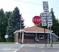
Nettie is a census-designated place (CDP) in Nicholas County, West Virginia, United States. Nettie is the location of the southern convergence of West Virginia Route 39, and West Virginia Route 20. As of the 2010 census, its population was 568.[2]
References
- ↑ "US Gazetteer files: 2010, 2000, and 1990". United States Census Bureau. 2011-02-12. Retrieved 2011-04-23.
- 1 2 "American FactFinder". United States Census Bureau. Retrieved 2011-05-14.
Municipalities and communities of Nicholas County, West Virginia, United States | ||
|---|---|---|
| City | 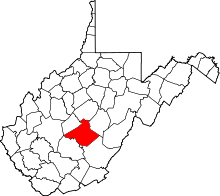 | |
| CDPs | ||
| Unincorporated communities |
| |
| Ghost towns | ||
| Footnotes | ‡This populated place also has portions in an adjacent county or counties | |
This article is issued from Wikipedia - version of the 11/4/2016. The text is available under the Creative Commons Attribution/Share Alike but additional terms may apply for the media files.