Fenwick, West Virginia
| Fenwick | |
|---|---|
| Census-designated place (CDP) | |
| Fenwick | |
 Fenwick Location within the state of West Virginia | |
| Coordinates: 38°13′43″N 80°34′56″W / 38.22861°N 80.58222°WCoordinates: 38°13′43″N 80°34′56″W / 38.22861°N 80.58222°W | |
| Country | United States |
| State | West Virginia |
| County | Nicholas |
| Area[1] | |
| • Total | 0.153 sq mi (0.40 km2) |
| • Land | 0.141 sq mi (0.37 km2) |
| • Water | 0.012 sq mi (0.03 km2) |
| Population (2010)[2] | |
| • Total | 116 |
| • Density | 760/sq mi (290/km2) |
| Time zone | Eastern (EST) (UTC-5) |
| • Summer (DST) | EDT (UTC-4) |
Fenwick is a census-designated place (CDP) in eastern Nicholas County, West Virginia, United States, adjacent to and immediately west of Richwood. As of the 2010 census, its population was 116.[2] The town is situated at the bottomland surrounding the mouth of the Big Laurel Creek at its confluence with the Cherry River and has an elevation of 649 m (2129 ft).[3] Fenwick is also the location of the convergence of three state highways: WV 55, WV 39, and WV 20 and acts as the western terminus of the Highland Scenic Highway.
References
- ↑ "US Gazetteer files: 2010, 2000, and 1990". United States Census Bureau. 2011-02-12. Retrieved 2011-04-23.
- 1 2 "American FactFinder". United States Census Bureau. Retrieved 2011-05-14.
- ↑ U.S. Geological Survey Geographic Names Information System: Fenwick, West Virginia
Municipalities and communities of Nicholas County, West Virginia, United States | ||
|---|---|---|
| City | 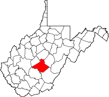 | |
| CDPs | ||
| Unincorporated communities |
| |
| Ghost towns | ||
| Footnotes | ‡This populated place also has portions in an adjacent county or counties | |
This article is issued from Wikipedia - version of the 9/4/2016. The text is available under the Creative Commons Attribution/Share Alike but additional terms may apply for the media files.