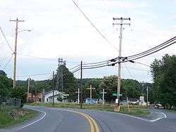
Craigsville, West Virginia
| Craigsville, West Virginia | |
|---|---|
| CDP | |
 | |
 Location of Craigsville, West Virginia | |
| Coordinates: 38°20′0″N 80°38′34″W / 38.33333°N 80.64278°WCoordinates: 38°20′0″N 80°38′34″W / 38.33333°N 80.64278°W | |
| Country | United States |
| State | West Virginia |
| County | Nicholas |
| Area | |
| • Total | 6.1 sq mi (15.7 km2) |
| • Land | 6.1 sq mi (15.7 km2) |
| • Water | 0.0 sq mi (0.0 km2) |
| Elevation | 2,313 ft (705 m) |
| Population (2010)[1] | |
| • Total | 2,213 |
| • Density | 360/sq mi (140/km2) |
| Time zone | Eastern (EST) (UTC-5) |
| • Summer (DST) | EDT (UTC-4) |
| ZIP code | 26205 |
| Area code(s) | 304 |
| FIPS code | 54-18604[2] |
| GNIS feature ID | 1550820[3] |
Craigsville is a census-designated place (CDP) in Nicholas County, West Virginia, United States. The population was 2,213 at the 2010 census.[1]
Geography
Craigsville is located at 38°20′0″N 80°38′34″W / 38.33333°N 80.64278°W (38.333389, -80.642766).[4]
According to the United States Census Bureau, the CDP has a total area of 6.1 square miles (15.7 km²), all of it land.
History
The community derives its name from James Craig, an original owner of the town site.[5]
Located near Craigsville is the Beaver Mill, listed on the National Register of Historic Places in 2001.[6]
Demographics
As of the census[2] of 2000, there were 2,204 people, 920 households, and 655 families residing in the CDP. The population density was 364.1 people per square mile (140.7/km²). There were 1,007 housing units at an average density of 166.4/sq mi (64.3/km²). The racial makeup of the CDP was 99.36% White, 0.09% African American, 0.27% Native American, 0.05% Asian, and 0.23% from two or more races. Hispanic or Latino of any race were 0.23% of the population.
There were 920 households out of which 30.3% had children under the age of 18 living with them, 58.0% were married couples living together, 11.0% had a female householder with no husband present, and 28.7% were non-families. 25.9% of all households were made up of individuals and 13.3% had someone living alone who was 65 years of age or older. The average household size was 2.40 and the average family size was 2.86.
In the CDP the population was spread out with 24.1% under the age of 18, 8.2% from 18 to 24, 26.1% from 25 to 44, 25.7% from 45 to 64, and 15.9% who were 65 years of age or older. The median age was 39 years. For every 100 females there were 91.7 males. For every 100 females age 18 and over, there were 86.9 males.
The median income for a household in the CDP was $24,631, and the median income for a family was $30,612. Males had a median income of $28,606 versus $18,150 for females. The per capita income for the CDP was $13,233. About 15.4% of families and 19.8% of the population were below the poverty line, including 25.4% of those under age 18 and 3.9% of those age 65 or over.
References
- 1 2 "American FactFinder". United States Census Bureau. Archived from the original on September 11, 2013. Retrieved 2011-05-14.
- 1 2 "American FactFinder". United States Census Bureau. Archived from the original on September 11, 2013. Retrieved 2008-01-31.
- ↑ "US Board on Geographic Names". United States Geological Survey. 2007-10-25. Retrieved 2008-01-31.
- ↑ "US Gazetteer files: 2010, 2000, and 1990". United States Census Bureau. 2011-02-12. Retrieved 2011-04-23.
- ↑ Kenny, Hamill (1945). West Virginia Place Names: Their Origin and Meaning, Including the Nomenclature of the Streams and Mountains. Piedmont, WV: The Place Name Press. p. 189.
- ↑ National Park Service (2010-07-09). "National Register Information System". National Register of Historic Places. National Park Service.
Municipalities and communities of Nicholas County, West Virginia, United States | ||
|---|---|---|
| City | 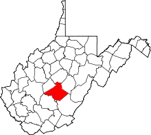 | |
| CDPs | ||
| Unincorporated communities |
| |
| Ghost towns | ||
| Footnotes | ‡This populated place also has portions in an adjacent county or counties | |