Navarino (CDP), Wisconsin
| Navarino, Wisconsin | |
|---|---|
| Census-designated place | |
 Navarino, Wisconsin | |
| Coordinates: 44°36′40″N 88°29′31″W / 44.61111°N 88.49194°WCoordinates: 44°36′40″N 88°29′31″W / 44.61111°N 88.49194°W | |
| Country | United States |
| State | Wisconsin |
| County | Shawano |
| Area | |
| • Total | 1.090 sq mi (2.82 km2) |
| • Land | 1.090 sq mi (2.82 km2) |
| • Water | 0 sq mi (0 km2) |
| Elevation | 804 ft (245 m) |
| Population (2010) | |
| • Total | 177 |
| • Density | 160/sq mi (63/km2) |
| Time zone | Central (CST) (UTC-6) |
| • Summer (DST) | CDT (UTC-5) |
| Area code(s) | 715 & 534 |
| GNIS feature ID | 1570118[1] |
Navarino is an unincorporated census-designated place located in the town of Navarino, Shawano County, Wisconsin, United States. Navarino is located on Wisconsin Highway 156 3.5 miles (5.6 km) north-northwest of Nichols, in section 25 of the town. As of the 2010 census, its population is 177.[2]
In the 1920s and earlier, the community which makes up the CDP was known as Galesburg.[3]
References
- ↑ U.S. Geological Survey Geographic Names Information System: Navarino (CDP), Wisconsin
- ↑ "American FactFinder". U.S. Census Bureau. Retrieved 15 April 2011.
- ↑ Taylor-Czaplewski, Anne. "1920 Navarino Township, Shawano County Plat Map". wigenweb.org. Retrieved 2016-10-02.
Municipalities and communities of Shawano County, Wisconsin, United States | ||
|---|---|---|
| Cities | 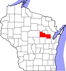 | |
| Villages | ||
| Towns | ||
| CDPs | ||
| Unincorporated communities | ||
| Indian reservations | ||
| Footnotes | ‡This populated place also has portions in an adjacent county or counties | |
This article is issued from Wikipedia - version of the 10/2/2016. The text is available under the Creative Commons Attribution/Share Alike but additional terms may apply for the media files.