Landstad, Wisconsin
| Landstad, Wisconsin | |
|---|---|
| Unincorporated community | |
|
Looking north in downtown Landstad | |
 Landstad, Wisconsin  Landstad, Wisconsin | |
| Coordinates: 44°39′38″N 88°26′37″W / 44.66056°N 88.44361°WCoordinates: 44°39′38″N 88°26′37″W / 44.66056°N 88.44361°W | |
| Country | United States |
| State | Wisconsin |
| County | Shawano |
| Elevation | 840 ft (260 m) |
| Time zone | Central (CST) (UTC-6) |
| • Summer (DST) | CDT (UTC-5) |
| Area code(s) | 715 & 534 |
| GNIS feature ID | 1567827[1] |

Landstad is an unincorporated community located in the town of Lessor, Shawano County, Wisconsin, United States. Landstad is located on Wisconsin Highway 47 5.5 miles (8.9 km) south of Bonduel.
Images
 Sign for Landstad on WIS 47
 Looking east in Landstad
References
Municipalities and communities of Shawano County, Wisconsin, United States | ||
|---|---|---|
| Cities | 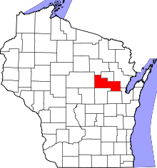 | |
| Villages | ||
| Towns | ||
| CDPs | ||
| Unincorporated communities | ||
| Indian reservations | ||
| Footnotes | ‡This populated place also has portions in an adjacent county or counties | |
This article is issued from Wikipedia - version of the 7/29/2016. The text is available under the Creative Commons Attribution/Share Alike but additional terms may apply for the media files.