| [3] |
Name on the Register[4] |
Image |
Date listed[5] |
Location |
City or town |
Description |
|---|
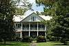
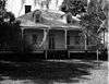
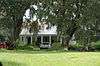
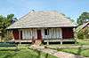
| 1 |
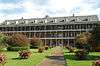
Academy of the Sacred Heart |
|
000000001975-02-18-0000February 18, 1975
(#75002079) |
Northeast of Grand Coteau
30°25′51″N 92°02′14″W / 30.430833°N 92.037222°W / 30.430833; -92.037222 (Academy of the Sacred Heart) |
Grand Coteau |
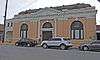
|
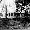
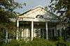
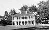
| 2 |
Arlington Plantation House |
Upload image |
000000001982-08-11-0000August 11, 1982
(#82004676) |
North of Washington off Louisiana Highway 103
30°38′48″N 92°04′19″W / 30.646667°N 92.071944°W / 30.646667; -92.071944 (Arlington Plantation House) |
Washington |
|
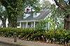
| 3 |
Burleigh House |
Upload image |
000000001982-08-11-0000August 11, 1982
(#82004673) |
Burleigh Lane
30°24′44″N 92°02′54″W / 30.412222°N 92.048333°W / 30.412222; -92.048333 (Burleigh House) |
Grand Coteau |
|
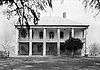
| 4 |
Chretien Point Plantation |
|
000000001977-05-26-0000May 26, 1977
(#77001519) |
2 miles southwest of Sunset on Blue Spring Rd.
30°23′26″N 92°05′55″W / 30.390556°N 92.098611°W / 30.390556; -92.098611 (Chretien Point Plantation) |
Sunset |
|
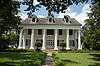
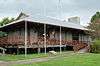
| 5 |
Martin Donato House |
|
000000002005-04-27-0000April 27, 2005
(#05000345) |
8343 U.S. Route 182
30°33′14″N 92°04′03″W / 30.553889°N 92.0675°W / 30.553889; -92.0675 (Martin Donato House) |
Opelousas |
|
| 6 |
Edward Benjamin Dubuisson House |
|
000000001997-02-14-0000February 14, 1997
(#97000059) |
437 N. Court St.
30°32′16″N 92°04′58″W / 30.537778°N 92.082778°W / 30.537778; -92.082778 (Edward Benjamin Dubuisson House) |
Opelousas |
|
| 7 |
Alexandre Fontenot fils House |
Upload image |
000000001982-10-22-0000October 22, 1982
(#82000453) |
South of Grand Prairie off Louisiana Highway 103
30°40′31″N 92°08′31″W / 30.675278°N 92.141944°W / 30.675278; -92.141944 (Alexandre Fontenot fils House) |
Grand Prairie |
|
| 8 |
Frozard Plantation House |
Upload image |
000000001982-08-12-0000August 12, 1982
(#82004674) |
South of Grand Coteau off Louisiana Highway 93
30°24′37″N 91°59′57″W / 30.410278°N 91.999167°W / 30.410278; -91.999167 (Frozard Plantation House) |
Grand Coteau |
|
| 9 |
Grand Coteau Historic District |
Upload image |
000000001980-11-25-0000November 25, 1980
(#80004320) |
Louisiana Highway 93
30°25′39″N 92°02′24″W / 30.4275°N 92.04°W / 30.4275; -92.04 (Grand Coteau Historic District) |
Grand Coteau |
|
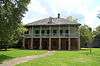
| 10 |
Homeplace |
Upload image |
000000001980-10-08-0000October 8, 1980
(#80004321) |
North of Washington on Louisiana Highway 182
30°40′44″N 92°03′27″W / 30.678889°N 92.0575°W / 30.678889; -92.0575 (Homeplace) |
Washington |
|
| 11 |
Labyche-Estorge House |
|
000000001982-10-05-0000October 5, 1982
(#82000454) |
427 N. Market St.
30°32′15″N 92°05′05″W / 30.5375°N 92.084722°W / 30.5375; -92.084722 (Labyche-Estorge House) |
Opelousas |
|
| 12 |
LaFleur House |
Upload image |
000000001998-03-05-0000March 5, 1998
(#98000179) |
753 Louisiana Highway 748
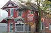
30°40′46″N 92°09′22″W / 30.679444°N 92.156111°W / 30.679444; -92.156111 (LaFleur House) |
Grand Prairie |
|
| 13 |
Dominique LaLanne House and Store |
Upload image |
000000001976-08-03-0000August 3, 1976
(#76002166) |
Southwestern corner of Bridge and Dejean Sts.
30°36′53″N 92°03′21″W / 30.614722°N 92.055833°W / 30.614722; -92.055833 (Dominique LaLanne House and Store) |
Washington |
|
| 14 |
Lamorandier-Prudhomme-Jackson House |
|
000000001983-12-22-0000December 22, 1983
(#83003635) |
Off U.S. Route 167
30°35′04″N 92°03′41″W / 30.584444°N 92.061389°W / 30.584444; -92.061389 (Lamorandier-Prudhomme-Jackson House) |
Opelousas |
|
| 15 |
John Lewis House |
Upload image |
000000001991-04-22-0000April 22, 1991
(#91000418) |
Address Restricted
|
Opelousas |
|
| 16 |
Liberty Theatre |
|
000000001987-02-19-0000February 19, 1987
(#87000177) |
200 W. Park Ave.
30°29′35″N 92°24′58″W / 30.493056°N 92.416111°W / 30.493056; -92.416111 (Liberty Theatre) |
Eunice |
|
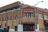
| 17 |
Midland Branch Railroad Depot |
|
000000001983-09-27-0000September 27, 1983
(#83000538) |
1st and North Sts.
30°29′37″N 92°24′54″W / 30.493611°N 92.415°W / 30.493611; -92.415 (Midland Branch Railroad Depot) |
Eunice |
|
| 18 |
Montet House |
Upload image |
000000002006-04-12-0000April 12, 2006
(#06000244) |
157 Shady Ln.
30°21′56″N 92°02′03″W / 30.365556°N 92.034167°W / 30.365556; -92.034167 (Montet House) |
Arnaudville |
|
| 19 |
Moundville Plantation House |
|
000000001976-12-12-0000December 12, 1976
(#76002167) |
2.5 miles northwest of Washington off Louisiana Highway 103
30°38′37″N 92°04′20″W / 30.643611°N 92.072222°W / 30.643611; -92.072222 (Moundville Plantation House) |
Washington |
|
| 20 |
Mouton House |
|
000000001991-08-09-0000August 9, 1991
(#91001045) |
261 N. Liberty St.
30°32′10″N 92°05′12″W / 30.536111°N 92.086667°W / 30.536111; -92.086667 (Mouton House) |
Opelousas |
|
| 21 |
Old Federal Building |
|
000000001982-12-28-0000December 28, 1982
(#82000455) |
162 S. Court St.
30°31′58″N 92°04′58″W / 30.532778°N 92.082778°W / 30.532778; -92.082778 (Old Federal Building) |
Opelousas |
|
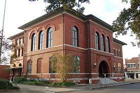
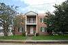
| 22 |
Opelousas City Hall |
|
000000001987-09-08-0000September 8, 1987
(#87001470) |
Junction of Market and Bellevue Sts. at Courthouse Sq.
30°32′02″N 92°05′02″W / 30.533889°N 92.083889°W / 30.533889; -92.083889 (Opelousas City Hall) |
Opelousas |
|
| 23 |
Opelousas Historic District |
|
000000001989-06-02-0000June 2, 1989
(#89000477) |
Roughly bounded by Bellevue, Court St., Landry St., and Market St.
30°32′01″N 92°05′00″W / 30.533611°N 92.083333°W / 30.533611; -92.083333 (Opelousas Historic District) |
Opelousas |
|
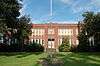
| 24 |
Plaisance School |
Upload image |
000000002004-08-23-0000August 23, 2004
(#04000080) |
3264 Louisiana Highway 167
30°37′07″N 92°07′57″W / 30.618611°N 92.1325°W / 30.618611; -92.1325 (Plaisance School) |
Plaisance |
|
| 25 |
Poiret Place |
|
000000001983-04-07-0000April 7, 1983
(#83000539) |
Northwest of Opelousas off Louisiana Highway 167
30°37′34″N 92°07′53″W / 30.626111°N 92.131389°W / 30.626111; -92.131389 (Poiret Place) |
Opelousas |
|
| 26 |
Michel Prudhomme House |
|
000000001977-05-24-0000May 24, 1977
(#77001518) |
1152 Prudhomme Circle
30°32′39″N 92°04′35″W / 30.544167°N 92.076389°W / 30.544167; -92.076389 (Michel Prudhomme House) |
Opelousas |
|
| 27 |
Ray Homestead |
|
000000001990-11-28-0000November 28, 1990
(#90001758) |
378 W. Bellevue St.
30°32′05″N 92°05′10″W / 30.534722°N 92.086111°W / 30.534722; -92.086111 (Ray Homestead) |
Opelousas |
|
| 28 |
Robin House and Barn |
|
000000001999-08-27-0000August 27, 1999
(#99001036) |
1616 Louisiana Highway 31
30°26′54″N 91°55′24″W / 30.448333°N 91.923333°W / 30.448333; -91.923333 (Robin House and Barn) |
Arnaudville |
|
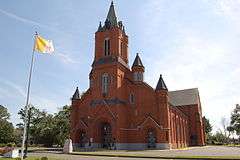
| 29 |
St. Landry Catholic Church |
|
000000001982-05-03-0000May 3, 1982
(#82004675) |
900 N. Union St.
30°32′34″N 92°04′45″W / 30.542778°N 92.079167°W / 30.542778; -92.079167 (St. Landry Catholic Church) |
Opelousas |
|
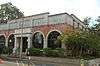
| 30 |
St. Landry Lumber Company |
|
000000001989-08-07-0000August 7, 1989
(#89001044) |
215 N. Railroad Ave.
30°32′08″N 92°05′16″W / 30.535556°N 92.087778°W / 30.535556; -92.087778 (St. Landry Lumber Company) |
Opelousas |
|
| 31 |
Starvation Point |
Upload image |
000000001980-05-15-0000May 15, 1980
(#80004323) |
North of Washington off Louisiana Highways 10/132
30°39′01″N 92°03′48″W / 30.650278°N 92.063333°W / 30.650278; -92.063333 (Starvation Point) |
Washington |
|
| 32 |
Sunset High School |
|
000000001999-05-12-0000May 12, 1999
(#99000556) |
223 Marie St.
30°24′47″N 92°03′54″W / 30.413056°N 92.065°W / 30.413056; -92.065 (Sunset High School) |
Sunset |
|
| 33 |
Venus House |
|
000000001991-04-22-0000April 22, 1991
(#91000419) |
Junction of U.S. Route 190 and Academy St.
30°31′52″N 92°04′29″W / 30.531111°N 92.074722°W / 30.531111; -92.074722 (Venus House) |
Opelousas |
|
| 34 |
Washington Historic District |
Upload image |
000000001978-11-15-0000November 15, 1978
(#78003114) |
Louisiana Highway 182
30°36′54″N 92°03′33″W / 30.615°N 92.059167°W / 30.615; -92.059167 (Washington Historic District) |
Washington |
|
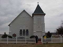
| 35 |
White's Chapel United Methodist Church |
|
000000001983-04-05-0000April 5, 1983
(#83000540) |
South of Bunkie off Louisiana Highway 29
30°50′01″N 92°12′12″W / 30.833611°N 92.203333°W / 30.833611; -92.203333 (White's Chapel United Methodist Church) |
Bunkie |
|
| 36 |
Wier House |
|
000000001995-04-07-0000April 7, 1995
(#95000368) |
310 E. Bellevue St.
30°32′03″N 92°04′52″W / 30.534167°N 92.081111°W / 30.534167; -92.081111 (Wier House) |
Opelousas |
|