National Register of Historic Places listings in Portland, Louisville, Kentucky
This is a list of properties and historic districts on the National Register of Historic Places in the Portland neighborhood of Louisville, Kentucky (roughly bounded by the Ohio River on the north; N. 10th St. to the east; W. Market St. to the south; and I-264 and the Shawnee Golf Course to the west. Latitude and longitude coordinates of the 32 sites listed on this page may be displayed in a map or exported in several formats by clicking on one of the links in the adjacent box.[1]
National Register sites elsewhere in Jefferson County are listed separately.
- This National Park Service list is complete through NPS recent listings posted December 16, 2016.[2]
Current listings
| [3] | Name on the Register | Image | Date listed[4] | Location | Description |
|---|---|---|---|---|---|
| 1 | Baker-Hawkins House | 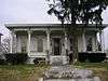 |
(#80001593) |
3603 W. Market St. 38°15′42″N 85°48′36″W / 38.261667°N 85.810000°W |
|
| 2 | C.A. Bridges Tobacco Warehouse | 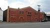 |
(#83002640) |
1719-1723 W. Main St. 38°15′34″N 85°46′45″W / 38.259444°N 85.779167°W |
|
| 3 | Brown Tobacco Warehouse | 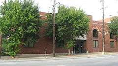 |
(#83002643) |
1019-1025 W. Main St. 38°15′29″N 85°46′03″W / 38.258056°N 85.767500°W |
|
| 4 | Firehouse No. 13 | 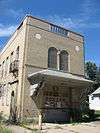 |
(#81000284) |
100 N. 34th St. 38°15′44″N 85°48′25″W / 38.262361°N 85.806944°W |
|
| 5 | Givens Headley and Co. Tobacco Warehouse |  |
(#83002672) |
1119-1121 W. Main St. 38°15′30″N 85°46′09″W / 38.258333°N 85.769167°W |
|
| 6 | Greve, Burlage, and Company |  |
(#83002674) |
312-316 N. 15th St. 38°15′43″N 85°46′28″W / 38.261944°N 85.774444°W |
|
| 7 | Greve, Buhrlage, and Company |  |
(#83002675) |
1501 Lytle St. 38°15′41″N 85°46′28″W / 38.261389°N 85.774444°W |
|
| 8 | Benjamin Grove House |  |
(#84000371) |
518 N. 26th St. 38°16′13″N 85°47′27″W / 38.270139°N 85.790833°W |
|
| 9 | Ideal Theatre |  |
(#83002686) |
2315-2319 W. Market St. 38°15′33″N 85°47′20″W / 38.259028°N 85.788750°W |
|
| 10 | James F. Irvin House | 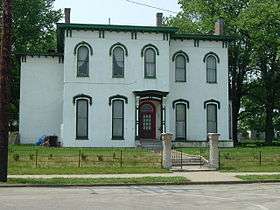 |
(#83002688) |
2910 Northwestern Parkway 38°16′30″N 85°47′40″W / 38.275000°N 85.794444°W |
|
| 11 | Lower West Market Street District |  |
(#82001561) |
1500-2200 W. Market St. 38°15′28″N 85°46′51″W / 38.257778°N 85.780833°W |
|
| 12 | Meek-Miller House |  |
(#79001012) |
3123 Northwestern Parkway 38°16′31″N 85°47′54″W / 38.275389°N 85.798333°W |
|
| 13 | Monon Freight Depot |  |
(#83002707) |
1400 W. Main St. 38°15′30″N 85°46′24″W / 38.258333°N 85.773333°W |
|
| 14 | Montgomery Street School | 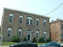 |
(#82002713) |
2500-2506 Montgomery St. 38°16′18″N 85°47′19″W / 38.271667°N 85.788611°W |
|
| 15 | National Foundry and Machine Company | 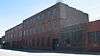 |
(#80001610) |
1402 W. Main St. 38°15′30″N 85°46′28″W / 38.258333°N 85.774444°W |
|
| 16 | National Tobacco Work Branch Stemmery | 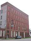 |
(#83002709) |
2410-2418 W. Main St. 38°15′36″N 85°47′25″W / 38.260000°N 85.790278°W |
|
| 17 | National Tobacco Works | 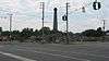 |
(#83002710) |
1800-1810 W. Main St. 38°15′32″N 85°46′50″W / 38.258889°N 85.780556°W |
|
| 18 | National Tobacco Works Branch Drying House |  |
(#83002711) |
2400 W. Main St. 38°15′36″N 85°47′24″W / 38.260000°N 85.790000°W |
|
| 19 | Peaslee-Gaulbert Warehouse |  |
(#83002719) |
1427 Lytle St. 38°15′41″N 85°46′27″W / 38.261389°N 85.774167°W |
|
| 20 | Planter's Tobacco Warehouse |  |
(#83002723) |
1027-1031 W. Main St. 38°15′29″N 85°46′04″W / 38.258056°N 85.767778°W |
|
| 21 | Portland Historic District |  |
(#80001615) |
Roughly bounded by Missouri Ave., Pflanz Ave., Bank, N. 33rd, and N. 37th Sts. 38°16′28″N 85°48′08″W / 38.274444°N 85.802222°W |
|
| 22 | Portland Proper |  |
(#06000812) |
31st St. and Northwestern Parkway 38°16′42″N 85°48′18″W / 38.278333°N 85.805000°W |
|
| 23 | J.V. Reed and Company |  |
(#83002725) |
1100 W. Main St. 38°15′28″N 85°46′06″W / 38.257778°N 85.768333°W |
|
| 24 | Theodore Roosevelt Elementary School |  |
(#82002719) |
222 N. 17th St. 38°15′41″N 85°46′41″W / 38.261389°N 85.778056°W |
|
| 25 | St. Cecilia School Building | 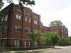 |
(#04001252) |
2530 Slevin St. 38°15′54″N 85°47′30″W / 38.265000°N 85.791667°W |
|
| 26 | St. Patrick's Roman Catholic Church, Rectory, and School | 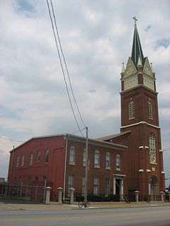 |
(#82002723) |
1301-1305 W. Market St. 38°15′26″N 85°46′19″W / 38.257222°N 85.771944°W |
|
| 27 | Steam Engine Company No. 4 | 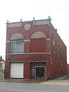 |
(#80004497) |
1617 W. Main St. 38°15′33″N 85°46′38″W / 38.259167°N 85.777222°W |
|
| 28 | Thornburgh House | 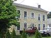 |
(#83003735) |
376 N. 26th St. 38°16′00″N 85°47′35″W / 38.266667°N 85.792917°W |
|
| 29 | Tobacco Realty Company |  |
(#83002742) |
118-126 N. 10th St. 38°15′31″N 85°46′00″W / 38.258611°N 85.766667°W |
|
| 30 | U.S. Marine Hospital | |
(#78001368) |
2215 Portland Ave. 38°16′14″N 85°47′04″W / 38.270556°N 85.784444°W |
|
| 31 | Western Junior High School |  |
(#83002748) |
22nd and Main Sts. 38°15′37″N 85°47′12″W / 38.260278°N 85.786667°W |
|
| 32 | Wrampelmeier Furniture Company |  |
(#83002754) |
226-228 N. 15th St. 38°15′40″N 85°46′29″W / 38.261083°N 85.774722°W |
Former listings
| [3] | Name on the Register | Image | Date listed | Date removed | Location | Summary |
|---|---|---|---|---|---|---|
| 1 | William G. Meier Warehouse | Upload image | (#83002704) | 2100 Rowan St. 38°15′40″N 85°47′04″W / 38.261165°N 85.784408°W |
||
| 2 | National Tobacco Works Warehouse | Upload image | (#83002712) | 101-113 S. 24th St. 38°15′35″N 85°47′20″W / 38.259834°N 85.78885°W |
See also
| Wikimedia Commons has media related to National Register of Historic Places in Louisville, Kentucky. |
- National Register of Historic Places listings in Jefferson County, Kentucky
- List of National Historic Landmarks in Kentucky
- List of attractions and events in the Louisville metropolitan area
References
- ↑ The latitude and longitude information provided in this table was derived originally from the National Register Information System, which has been found to be fairly accurate for about 99% of listings. For about 1% of NRIS original coordinates, experience has shown that one or both coordinates are typos or otherwise extremely far off; some corrections may have been made. A more subtle problem causes many locations to be off by up to 150 yards, depending on location in the country: most NRIS coordinates were derived from tracing out latitude and longitudes off of USGS topographical quadrant maps created under the North American Datum of 1927, which differs from the current, highly accurate WGS84 GPS system used by most on-line maps. Chicago is about right, but NRIS longitudes in Washington are higher by about 4.5 seconds, and are lower by about 2.0 seconds in Maine. Latitudes differ by about 1.0 second in Florida. Some locations in this table may have been corrected to current GPS standards.
- ↑ "National Register of Historic Places: Weekly List Actions". National Park Service, United States Department of the Interior. Retrieved on December 16, 2016.
- 1 2 Numbers represent an ordering by significant words. Various colorings, defined here, differentiate National Historic Landmarks and historic districts from other NRHP buildings, structures, sites or objects.
- ↑ The eight-digit number below each date is the number assigned to each location in the National Register Information System database, which can be viewed by clicking the number.
| Topics | |
|---|---|
| Lists by states |
|
| Lists by insular areas | |
| Lists by associated states | |
| Other areas | |
| |

This article is issued from Wikipedia - version of the 11/14/2016. The text is available under the Creative Commons Attribution/Share Alike but additional terms may apply for the media files.