National Register of Historic Places listings in Chouteau County, Montana
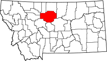
Location of Chouteau County in Montana
This is a list of the National Register of Historic Places listings in Chouteau County, Montana. It is intended to be a complete list of the properties and districts on the National Register of Historic Places in Chouteau County, Montana, United States. The locations of National Register properties and districts for which the latitude and longitude coordinates are included below, may be seen in a map.[1]
There are 22 properties and districts listed on the National Register in the county, including 1 National Historic Landmark.
- This National Park Service list is complete through NPS recent listings posted December 16, 2016.[2]
Listings county-wide
| [3] | Name on the Register | Image | Date listed[4] | Location | City or town | Description |
|---|---|---|---|---|---|---|
| 1 | I.G. Baker House | 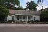 |
(#80002403) |
1604 Front St. 47°49′08″N 110°39′35″W / 47.818889°N 110.659722°W |
Fort Benton | |
| 2 | Chouteau County Courthouse |  |
(#80002404) |
1308 Franklin St. 47°49′03″N 110°39′53″W / 47.8175°N 110.664722°W |
Fort Benton | |
| 3 | Citadel Rock | Upload image | (#74001095) |
East of Fort Benton 47°49′52″N 110°04′28″W / 47.831111°N 110.074444°W |
Fort Benton | |
| 4 | Eagle Butte School | Upload image | (#08001383) |
Eagle Butte School Rd., 23 miles off Montana Highway 80 47°53′09″N 110°10′12″W / 47.885712°N 110.169923°W |
Fort Benton | |
| 5 | First National Bank of Geraldine |  |
(#07001363) |
311 Main St. 47°36′09″N 110°15′53″W / 47.6025°N 110.264722°W |
Geraldine | |
| 6 | Fort Benton Bridge | 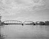 |
(#80002406) |
Spans the Missouri River 47°49′02″N 110°39′38″W / 47.817222°N 110.660556°W |
Fort Benton | |
| 7 | Fort Benton Engine House | 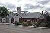 |
(#80002407) |
Front and 15th Sts. 47°49′02″N 110°39′38″W / 47.817222°N 110.660556°W |
Fort Benton | |
| 8 | Fort Benton Historic District | 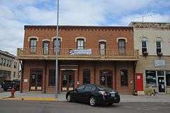 |
(#66000431) |
Front St. (1220 through 1900 block) levee, and bridge 47°49′04″N 110°40′02″W / 47.817778°N 110.667222°W |
Fort Benton | |
| 10 | Geraldine Milwaukee Depot | 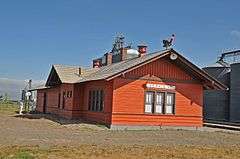 |
(#97000254) |
Railroad Ave., approximately 10 miles south of Montana Highway 80 47°36′14″N 110°15′55″W / 47.603889°N 110.265278°W |
Geraldine | |
| 11 | Grand Union Hotel | 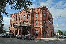 |
(#76001121) |
14th and Front Sts. 47°48′52″N 110°40′08″W / 47.814444°N 110.668889°W |
Fort Benton | |
| 12 | Judith Landing Historic District | Upload image | (#75001081) |
Address Restricted |
Winifred | Extends into Fergus County. Boundary increase on 2014-04-11. |
| 13 | Lewis and Clark Camp at Slaughter River | Upload image | (#74001094) |
40 miles south of the Big Sandy River on the Missouri River 47°43′04″N 109°50′59″W / 47.717778°N 109.849722°W |
Big Sandy | |
| 14 | Lonetree | Upload image | (#80002410) |
South of Geraldine 47°32′37″N 110°17′21″W / 47.543611°N 110.289167°W |
Geraldine | |
| 15 | Masonic Building | 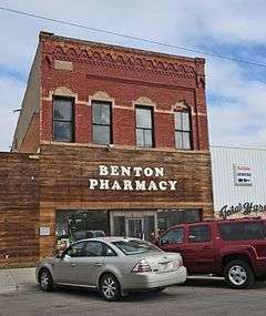 |
(#80002408) |
1418 Front St. 47°49′03″N 110°39′41″W / 47.8175°N 110.661389°W |
Fort Benton | |
| 16 | St. Paul's Episcopal Church |  |
(#80002409) |
14th and Chouteau Sts. 47°49′06″N 110°39′58″W / 47.818333°N 110.666111°W |
Fort Benton | |
| 17 | Shonkin Creek Bridge | Upload image | (#12000169) |
Approximately mile 21 on Shonkin Rd. 47°33′57″N 110°33′11″W / 47.565697°N 110.552999°W |
Geraldine vicinity | part of the Montana's Steel Stringer and Steel Girder Bridges MPS |
| 18 | Square Butte Jail | Upload image | (#98000888) |
Salsbury Ave. 47°31′02″N 110°11′52″W / 47.517222°N 110.197778°W |
Square Butte | |
| 19 | Square Butte School | Upload image | (#13000496) |
Northwest corner of Diederick St. and Broadway 47°31′00″N 110°12′08″W / 47.516567°N 110.202230°W |
Square Butte | |
| 20 | Teton River Crossing on the Whoop-Up Trail | Upload image | (#93000275) |
Address Restricted |
Carter | |
| 21 | Virgelle Mercantile and Virgelle State Bank | 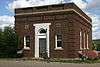 |
(#97000315) |
County Road 430, approximately 6.3 miles south of U.S. Route 87 48°00′57″N 110°14′55″W / 48.015833°N 110.248611°W |
Virgelle | |
| 22 | West Quincy Granite Quarry | Upload image | (#00000163) |
Flat Creek Rd. 47°32′42″N 110°16′58″W / 47.545°N 110.282778°W |
Square Butte |
Former listings
| [3] | Name on the Register | Image | Date listed | Date removed | Location | City or town | Summary |
|---|---|---|---|---|---|---|---|
| 1 | Chouteau County Jail | Upload image | (#80002405) | Washington and Fourteenth Sts. |
Fort Benton |
See also
| Wikimedia Commons has media related to National Register of Historic Places in Chouteau County, Montana. |
- List of National Historic Landmarks in Montana
- National Register of Historic Places listings in Montana
References
- ↑ The latitude and longitude information provided in this table was derived originally from the National Register Information System, which has been found to be fairly accurate for about 99% of listings. For about 1% of NRIS original coordinates, experience has shown that one or both coordinates are typos or otherwise extremely far off; some corrections may have been made. A more subtle problem causes many locations to be off by up to 150 yards, depending on location in the country: most NRIS coordinates were derived from tracing out latitude and longitudes off of USGS topographical quadrant maps created under the North American Datum of 1927, which differs from the current, highly accurate WGS84 GPS system used by most on-line maps. Chicago is about right, but NRIS longitudes in Washington are higher by about 4.5 seconds, and are lower by about 2.0 seconds in Maine. Latitudes differ by about 1.0 second in Florida. Some locations in this table may have been corrected to current GPS standards.
- ↑ "National Register of Historic Places: Weekly List Actions". National Park Service, United States Department of the Interior. Retrieved on December 16, 2016.
- 1 2 Numbers represent an ordering by significant words. Various colorings, defined here, differentiate National Historic Landmarks and historic districts from other NRHP buildings, structures, sites or objects.
- ↑ The eight-digit number below each date is the number assigned to each location in the National Register Information System database, which can be viewed by clicking the number.
| Topics | |
|---|---|
| Lists by states |
|
| Lists by insular areas | |
| Lists by associated states | |
| Other areas | |
| |
Municipalities and communities of Chouteau County, Montana, United States | ||
|---|---|---|
| City | | |
| Towns | ||
| CDPs | ||
| Unincorporated communities | ||
| Ghost town | ||
| Indian reservation | ||
| Footnotes | ‡This populated place also has portions in an adjacent county or counties | |
This article is issued from Wikipedia - version of the 5/8/2016. The text is available under the Creative Commons Attribution/Share Alike but additional terms may apply for the media files.