Nansene, Oregon
| Nansene, Oregon | |
|---|---|
| Unincorporated community | |
 Nansene, Oregon  Nansene, Oregon | |
| Coordinates: 45°24′15″N 121°03′24″W / 45.40417°N 121.05667°WCoordinates: 45°24′15″N 121°03′24″W / 45.40417°N 121.05667°W | |
| Country | United States |
| State | Oregon |
| County | Wasco |
| Elevation | 2,044 ft (623 m) |
| Time zone | Pacific (PST) (UTC-8) |
| • Summer (DST) | PDT (UTC-7) |
| Area code(s) | 458 and 541 |
| Coordinates and elevation from United States Geological Survey[1] | |
Nansene is an unincorporated community in Wasco County, in the U.S. state of Oregon.[1] It lies along Long Hollow Market Road southeast of the small city of Dufur. Between Nansene and Dufur, the road crosses Dry Creek, a tributary of Fifteenmile Creek.[2]
The name Nansene probably derives from a Native American word describing Fifteenmile Creek.[3] A post office operated in Nansene from 1880 through 1894.[3]
In the late 19th century, children in the community attended Nansene School. A school report published in The Dalles Weekly Chronicle in 1898 mentions enrollment of 5 boys and 14 girls for a total of 19 students.[4]
References
- 1 2 "Nansene". Geographic Names Information System. United States Geological Survey. May 22, 1986. Retrieved December 9, 2014.
- ↑ Oregon Atlas & Gazetteer (7th ed.). Yarmouth, Maine: DeLorme. 2008. pp. 31, 72. ISBN 978-0-89933-347-2.
- 1 2 McArthur, Lewis A.; Lewis L. McArthur (2003) [1928]. Oregon Geographic Names (7th ed.). Portland, Oregon: Oregon Historical Society Press. p. 689. ISBN 0-87595-277-1.
- ↑ "The Dalles Weekly Chronicle" (Reprint from May 25, 1898 issue). Historic Oregon Newspapers. University of Oregon Libraries. Retrieved December 10, 2014.
Municipalities and communities of Wasco County, Oregon, United States | ||
|---|---|---|
| Cities | 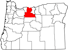 | |
| CDPs | ||
| Unincorporated communities | ||
| Indian reservation | ||
| Ghost towns | ||
This article is issued from Wikipedia - version of the 7/31/2016. The text is available under the Creative Commons Attribution/Share Alike but additional terms may apply for the media files.