Nador Province
Not to confuse with Nadhour, Tunisia.
Not to confuse with Nador, its capital city.
| Nador Province ⵜⴰⵏⴻⴱⴹⵉⵜ ⵏ ⴻⵏⵏⴰⴹⵓⵔ الناظور | |
|---|---|
| Province | |
|
Nador Province, Oriental Region, Morocco | |
| Country |
|
| Region | Oriental |
| Capital | Nador |
| Population (2004) | |
| • Total | 522,663 |

Nador is a province in the Oriental Region of Morocco. Its population in 2004 was 728,634.[1]
It is situated east from Driouch Province and west from Berkane Province.
Major cities and towns
The major cities and towns are:[2]
- Al Aaroui
- Beni Ensar / Aït Nsar
- Bni Chiker
- Dar El Kebdani
- Farkhana
- Ihddaden
- Jaadar
- Kariat Arekmane
- Nador
- Ras El Ma
- Segangan/ Zeghanghane
- Selouane
- Tiztoutine
- Touima
- Zaio
Subdivisions
The province is divided administratively into the following:[3]
| Name | Geographic code | Type | Households | Population (2004) | Foreign population | Moroccan population | Notes |
|---|---|---|---|---|---|---|---|
| Al Aaroui | 381.01.01. | Municipality | 6923 | 36021 | 8 | 36013 | |
| Beni Ensar / Aït Nsar | 381.01.03. | Municipality | 6799 | 31800 | 75 | 31725 | |
| Nador | 381.01.05. | Municipality | 26961 | 126207 | 137 | 126070 | |
| Zaio | 381.01.07. | Municipality | 6067 | 29851 | 10 | 29841 | |
| Zeghanghane | 381.01.09. | Municipality | 4242 | 20181 | 6 | 20175 | |
| Dar El Kebdani | 381.03.07. | Rural commune | 2023 | 10674 | 5 | 10669 | 2990 residents live in the center, called Dar El Kebdani; 7684 residents live in rural areas. |
| Bni Bouifrour | 381.05.01. | Rural commune | 3537 | 17090 | 1 | 17089 | 9497 residents live in the center, called Jaadar; 7593 residents live in rural areas. |
| Bni Chiker | 381.05.03. | Rural commune | 4464 | 23050 | 4 | 23046 | 4188 residents live in the center, called Bni Chiker; 18862 residents live in rural areas. |
| Bni Sidel Jbel | 381.05.05. | Rural commune | 1890 | 9623 | 0 | 9623 | |
| Bni Sidel Louta | 381.05.07. | Rural commune | 1475 | 7331 | 1 | 7330 | |
| Bouarg | 381.05.09. | Rural commune | 4385 | 23379 | 3 | 23376 | 6909 residents live in the center, called Touima; 16470 residents live in rural areas. |
| Farkhana | 381.05.11. | Rural commune | 3900 | 20433 | 3 | 20430 | 10994 residents live in the center, called Farkhana; 9439 residents live in rural areas. |
| Iaazzanene | 381.05.13. | Rural commune | 2305 | 11815 | 1 | 11814 | |
| Ihaddadene | 381.05.15. | Rural commune | 5119 | 26582 | 12 | 26570 | 25480 residents live in the center, called Ihddaden; 1102 residents live in rural areas. |
| Iksane | 381.05.17. | Rural commune | 1744 | 9001 | 1 | 9000 | |
| Selouane | 381.05.19. | Rural commune | 4878 | 24877 | 12 | 24865 | 9211 residents live in the center, called Selouane; 15666 residents live in rural areas. |
| Afsou | 381.07.01. | Rural commune | 493 | 3413 | 0 | 3413 | |
| Al Barkanyene | 381.07.03. | Rural commune | 298 | 1619 | 0 | 1619 | |
| Arekmane | 381.07.05. | Rural commune | 3720 | 18998 | 1 | 18997 | 5266 residents live in the center, called Kariat Arekmane; 13732 residents live in rural areas. |
| Bni Oukil Oulad M'Hand | 381.07.07. | Rural commune | 1804 | 10496 | 3 | 10493 | |
| Hassi Berkane | 381.07.09. | Rural commune | 1344 | 8113 | 0 | 8113 | |
| Oulad Daoud Zkhanine | 381.07.11. | Rural commune | 750 | 3666 | 0 | 3666 | |
| Oulad Settout | 381.07.13. | Rural commune | 3875 | 22173 | 3 | 22170 | |
| Ras El Ma | 381.07.15. | Rural commune | 2064 | 9888 | 6 | 9882 | 4532 residents live in the center, called Ras El Ma; 5356 residents live in rural areas. |
| Tiztoutine | 381.07.17. | Rural commune | 1732 | 10040 | 0 | 10040 | 4050 residents live in the center, called Tiztoutine; 5990 residents live in rural areas. |
| Oulad Amghar | 381.09.19. | Rural commune | 1005 | 6342 | 1 | 6341 | |
References
- ↑ "World Gazetteer: Nador – profile of geographical entity including name variants". Archived from the original on 9 February 2013.
- ↑ "World Gazetteer: Nador – largest cities". Archived from the original on 19 September 2012.
- ↑ "Recensement général de la population et de l'habitat de 2004" (PDF). Haut-commissariat au Plan, Lavieeco.com. Retrieved 27 April 2012.
Capital: Nador | ||
| Municipalities | ||
| Rural communes | ||
Capital: Oujda | ||
| Provinces | 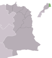 | |
| Cities |
| |
Coordinates: 35°10′42″N 2°55′51″W / 35.17833°N 2.93083°W
This article is issued from Wikipedia - version of the 6/23/2016. The text is available under the Creative Commons Attribution/Share Alike but additional terms may apply for the media files.