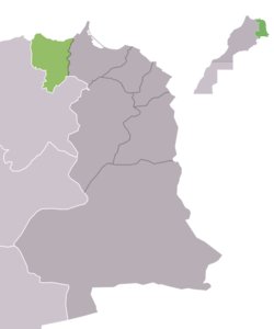
Driouch Province
| Driouch Province ⵜⴰⵏⴻⴱⴹⵉⵜ ⵏ ⴻⴷⴷⵔⵉⵡⴻⵛ الدريوش | |
|---|---|
| Province | |
 | |
| Country |
|
| Region | Oriental |
| Capital | Driouch |
| Area | |
| • Total | 2,867 km2 (1,107 sq mi) |
| Population (2004) | |
| • Total | 222.987 |
Driouch Province or Eddriwec Province (Berber: Eddriwec, ⴻⴷⴷⵔⵉⵡⴻⵛ; Arabic: الدريوش) is a province in Morocco that was formed in 2009[1] by dividing the Nador Province into two parts, all falling under the Oriental administrative region of northeastern Morocco. The province of Driouch has a population of 222,987 people as of 2004.
Subdivisions
The province is divided administratively into the following:[2]
| Name | Geographic code | Type | Households | Population (2004) | Foreign population | Moroccan population | Notes |
|---|---|---|---|---|---|---|---|
| Driouch | 381.03.09. | Municipality | 5183 | 28545 | 5 | 28540 | 10381 residents live in the center, called Driouch; 18164 residents live in rural areas. |
| Midar | 381.09.13. | Municipality | 3155 | 16022 | 3 | 16019 | 13229 residents live in the center, called Midar; 2793 residents live in rural areas. |
| Ben Taieb | 381.09.03. | Rural commune | 3928 | 20891 | 2 | 20889 | 10446 residents live in the center, called Ben Taieb; 10445 residents live in rural areas. |
| Temsamane | 381.09.25. | Rural commune | 2928 | 14937 | 2 | 14935 | 2188 residents live in the center, called Kerouna; 12749 residents live in rural areas. |
| Trougout | 381.09.27. | Rural commune | 1745 | 11541 | 0 | 11541 | |
| Ijermaouas | 381.09.11. | Rural commune | 1789 | 11288 | 1 | 11287 | |
| Ain Zohra | 381.03.01. | Rural commune | 1754 | 11258 | 0 | 11258 | |
| Ait Mait | 381.03.03. | Rural commune | 1224 | 7188 | 0 | 7188 | |
| Amejjaou | 381.03.05. | Rural commune | 1038 | 5977 | 0 | 5977 | |
| Oulad Boubker | 381.03.11. | Rural commune | 915 | 5765 | 0 | 5765 | |
| Tazaghine | 381.03.13. | Rural commune | 910 | 5032 | 4 | 5028 | |
| Azlaf | 381.09.01. | Rural commune | 1004 | 5337 | 0 | 5337 | |
| Bni Marghnine | 381.09.05. | Rural commune | 1416 | 7158 | 1 | 7157 | |
| Boudinar | 381.09.07. | Rural commune | 1957 | 10504 | 0 | 10504 | |
| Iferni | 381.09.09. | Rural commune | 1356 | 7527 | 0 | 7527 | |
| M'Hajer | 381.09.15. | Rural commune | 619 | 3232 | 1 | 3231 | |
| Ouardana | 381.09.17. | Rural commune | 1242 | 6921 | 0 | 6921 | |
| Tafersit | 381.09.21. | Rural commune | 2005 | 10403 | 0 | 10403 | 3555 residents live in the center, called Tafrisset; 6848 residents live in rural areas. |
| Talilit | 381.09.23. | Rural commune | 1115 | 6161 | 0 | 6161 | |
| Tsaft | 381.09.29. | Rural commune | 1786 | 10284 | 2 | 10282 | 2126 residents live in the center, called Kassita; 8158 residents live in rural areas. |
References
- ↑
- ↑ "Recensement général de la population et de l'habitat de 2004" (PDF). Haut-commissariat au Plan, Lavieeco.com. Retrieved 27 April 2012.
Capital: Driouch | ||
| municipalities | | |
| communes | ||
Capital: Oujda | ||
| Provinces |  | |
| Cities |
| |
Coordinates: 34°59′00″N 3°23′00″W / 34.9833°N 3.3833°W
This article is issued from Wikipedia - version of the 3/18/2016. The text is available under the Creative Commons Attribution/Share Alike but additional terms may apply for the media files.