N'Goussa
| N'Goussa ﻧﻘﻮﺳﺔ | |
|---|---|
| Commune and town | |
 | |
 N'Goussa | |
| Coordinates: DZ 32°8′27″N 5°18′30″E / 32.14083°N 5.30833°ECoordinates: DZ 32°8′27″N 5°18′30″E / 32.14083°N 5.30833°E | |
| Country |
|
| Province | Ouargla Province |
| District | N'Goussa District (coextensive) |
| Established[1] | 1984 |
| Area | |
| • Total | 2,740 km2 (1,060 sq mi) |
| Elevation | 127 m (417 ft) |
| Population (2008)[2] | |
| • Total | 16,581 |
| • Density | 6.1/km2 (16/sq mi) |
| Time zone | CET (UTC+1) |
N'Goussa (Arabic: ﻧﻘﻮﺳﺔ) is a town and commune, coextensive with the district of the same name, in Ouargla Province, Algeria. Some of its inhabitants speak the Ouargli language.[3] As of 2008, the population of the town was 19,039,[2] up from 13,344 in 1998,[4] with an annual population growth rate of 2.2%.[2] The town is on a local road, about 20 kilometres (12 mi) north of Ouargla on the way to El Hadjira further north.
Climate
N'Goussa has a hot desert climate (Köppen climate classification BWh), with very hot summers and mild winters. Rainfall is light and sporadic, and summers are particularly dry.
Education
4.4% of the population has a tertiary education, and another 12.2% has completed secondary education.[5] The overall literacy rate is 73.3%, and is 82.4% among males and 64.1% among females.[6]
Localities
The commune is composed of 14 localities:[7]
- N'Goussa
- Frane
- El Bour
- Hassi El Khefif
- El Khobna
- Oglat Larbaa
- Ben Azzouz
- Debiche
- Hamraya
- Ouahda
- Chegga
- Hassi Maali
- El Koum
- Hassi Cheta
References
- ↑ "Official website of the province of Ouarbla - N'Goussa" (in Arabic). Retrieved 25 February 2013.
- 1 2 3 "Population: Ouargla Wilaya" (PDF) (in French). Office National des Statistiques Algérie. Retrieved 24 February 2013.
- ↑ "Tagargrent, a language of Algeria". Ethnologue. Retrieved 25 February 2013.
- ↑ "Algeria Communes". Statoids. Retrieved 8 March 2013.
- ↑ "Structure relative de la population résidente des ménages ordinaires et collectifs âgée de 6 ans et plus selon le niveau d'instruction et la commune de résidence." (PDF) (in French). Office National des Statistiques Algérie. Retrieved 13 February 2013.
- ↑ "Taux d'analphabétisme et taux d'alphabétisation de la population âgée de 15 ans et plus, selon le sexe et la commune de résidence ." (PDF) (in French). Office National des Statistiques Algérie. Retrieved 13 February 2013.
- ↑ "Décret n° 84-365, fixant la composition, la consistance et les limites territoriale des communes. Wilaya d'El Oued" (PDF) (in French). Journal officiel de la République Algérienne,. 19 December 1984. p. 1551. Archived from the original (PDF) on 2 March 2013 or before. Retrieved 2 March 2013. Check date values in:
|archive-date=(help)
 |
El Guerrara (Ghardaïa) | El Hadjira | Touggourt El Bour |
|
| Ghardaïa | |
|||
| ||||
| | ||||
| Ouargla | Hassi Ben Abdellah Hassi Messaoud |
Capital: Ouargla | ||
| Ouargla District | 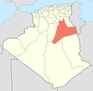 | |
| El Borma District | ||
| El Hadjira District | ||
| Hassi Messaoud District | ||
| Mégarine District | ||
| N'Goussa District | ||
| Sidi Khouïled District | ||
| Taïbet District | ||
| Témacine District | ||
| Touggourt District | ||