Chott, Algeria
For the geological landform, see Chott.
| Chott | |
|---|---|
| Village | |
 Chott | |
| Coordinates: DZ 31°57′44″N 5°23′20″E / 31.96222°N 5.38889°ECoordinates: DZ 31°57′44″N 5°23′20″E / 31.96222°N 5.38889°E | |
| Country |
|
| Province | Ouargla Province |
| District | Sidi Khouiled District |
| Commune | Ain Beida[1] |
| Elevation | 133 m (436 ft) |
| Time zone | CET (UTC+1) |
Chott is a village in the commune of Ain Beida,[1] in Sidi Khouiled District, Ouargla Province, Algeria. The village is located 2.5 kilometres (1.6 mi) north of Ain Beida and 5 kilometres (3.1 mi) east of the provincial capital Ouargla.[2]
References
- 1 2 "Décret n° 84-365, fixant la composition, la consistance et les limites territoriale des communes. Wilaya d'El Oued" (PDF) (in French). Journal officiel de la République Algérienne,. 19 December 1984. p. 1551. Archived from the original (PDF) on 2 March 2013 or before. Retrieved 2 March 2013. Check date values in:
|archive-date=(help) - ↑ "Chott, Ouargla, Algeria". Google Maps. Retrieved 1 May 2013.
Neighbouring towns and cities
 |
N'Goussa | El Hadjira El Bour |
Touggourt Sidi Khouiled |
|
| Ouargla | |
Haoud El Hamra El Borma | ||
| ||||
| | ||||
| Rouissat | Adjadja Ain Beida |
Hassi Messaoud |
Capital: Ouargla | ||
| Ouargla District | 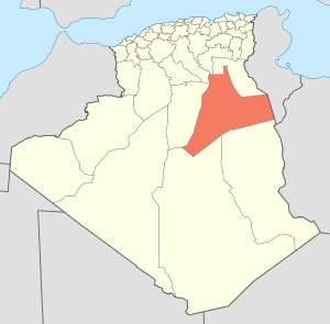 | |
| El Borma District | ||
| El Hadjira District | ||
| Hassi Messaoud District | ||
| Mégarine District | ||
| N'Goussa District | ||
| Sidi Khouïled District | ||
| Taïbet District | ||
| Témacine District | ||
| Touggourt District | ||
This article is issued from Wikipedia - version of the 5/1/2013. The text is available under the Creative Commons Attribution/Share Alike but additional terms may apply for the media files.