El Borma
| El Borma اﻟﺒﺮﻣﺔ | |
|---|---|
| Commune and town | |
 Location of El Borma commune within Ouargla Province | |
 El Borma Location of El Borma within Algeria | |
| Coordinates: DZ 31°39′23″N 9°10′45″E / 31.65639°N 9.17917°ECoordinates: DZ 31°39′23″N 9°10′45″E / 31.65639°N 9.17917°E | |
| Country |
|
| Province | Ouargla Province |
| District | El Borma District |
| Area[1] | |
| • Total | 47,261 km2 (18,248 sq mi) |
| Elevation | 252 m (827 ft) |
| Population (2008)[2] | |
| • Total | 3,205 |
| • Density | 0.068/km2 (0.18/sq mi) |
| Time zone | CET (UTC+1) |
El Borma (Arabic: اﻟﺒﺮﻣﺔ) is a town and commune, which is coextensive with El Borma District, in Ouargla Province, Algeria. According to the 2008 census it has a population of 3,250,[2] up from 1,997 in 1998.[3] and an annual population growth rate of 4.9%, the second highest in the province.[2] The town is located on the border with Tataouine Governorate, Tunisia.
Geography
El Borma is located amidst the vast sand dunes of the Grand Erg Oriental in eastern Algeria. The location is notable for its underground petroleum reservoirs.
Climate
El Borma has a hot desert climate (Köppen climate classification BWh) with long, extremely hot summers and short, warm winters. The climate is similar to the one of Ouargla. Daytime temperatures are soaring during summer months as they consistently turn around 45 °C (113 °F) between June and September.
| Climate data for El Borma | |||||||||||||
|---|---|---|---|---|---|---|---|---|---|---|---|---|---|
| Month | Jan | Feb | Mar | Apr | May | Jun | Jul | Aug | Sep | Oct | Nov | Dec | Year |
| Average high °C (°F) | 16.1 (61) |
19.1 (66.4) |
23.4 (74.1) |
28.2 (82.8) |
32.6 (90.7) |
37.4 (99.3) |
40.0 (104) |
39.2 (102.6) |
36.0 (96.8) |
29.6 (85.3) |
22.8 (73) |
17.6 (63.7) |
28.5 (83.31) |
| Daily mean °C (°F) | 10.1 (50.2) |
12.5 (54.5) |
16.1 (61) |
20.5 (68.9) |
24.8 (76.6) |
29.3 (84.7) |
31.1 (88) |
30.7 (87.3) |
28.1 (82.6) |
22.5 (72.5) |
16.3 (61.3) |
11.4 (52.5) |
21.12 (70.01) |
| Average low °C (°F) | 4.1 (39.4) |
5.9 (42.6) |
8.9 (48) |
12.9 (55.2) |
17.1 (62.8) |
21.2 (70.2) |
22.3 (72.1) |
22.3 (72.1) |
20.2 (68.4) |
15.4 (59.7) |
9.8 (49.6) |
5.3 (41.5) |
13.78 (56.8) |
| Average precipitation mm (inches) | 8 (0.31) |
5 (0.2) |
8 (0.31) |
4 (0.16) |
3 (0.12) |
0 (0) |
0 (0) |
1 (0.04) |
1 (0.04) |
4 (0.16) |
7 (0.28) |
5 (0.2) |
46 (1.82) |
| Source: climate-data.org[4] | |||||||||||||
Economy
El Borma's economy is supported by the petroleum industry, due to the oil fields in the area. Grazing is also significant, although limited because of the marginal plant life in the area. Agriculture is currently unfeasible due to the lack of sufficient water supplies.[1]
Transportation
El Borma is an isolated town, with no significant settlements or major roads nearby. A local road leads west to Hassi Messaoud about 300 kilometres (190 mi) to the west, and branches off to the south, reaching Ghadames in Libya and Debdeb in Illizi Province about 180 kilometres (110 mi) to the south.
The town is served by El Borma Airport across the border in Tunisia.[5]
Education
1.6% of the population has a tertiary education (the lowest in the province), and another 3.5% has completed secondary education.[6] The overall literacy rate is 42.6%, and is 54.7% among males and 28.5% among females. All three rates are the lowest in the province.[7]
Localities
The commune is composed of eight localities:[8]
- El Borma
- Rhoud El Baguel
- El Masder
- Bordj Saïf Fatima
- Bordj Bir El Djedid
- Bordj Bir Larache
- Keskassa
- Erg Yagoub
References
- 1 2 "Official website of the province of Ouargla - El Borma" (in Arabic). Retrieved 8 March 2013.
- 1 2 3 "Population: Ouargla Wilaya" (PDF) (in French). Office National des Statistiques Algérie. Retrieved 24 February 2013.
- ↑ "Algeria Communes". Statoids. Retrieved 8 March 2013.
- ↑ "Climate data for: El Borma". climate-data.org. Retrieved 8 March 2013.
- ↑ "El Borma Airport". OurAirports. Retrieved 8 March 2013.
- ↑ "Structure relative de la population résidente des ménages ordinaires et collectifs âgée de 6 ans et plus selon le niveau d'instruction et la commune de résidence." (PDF) (in French). Office National des Statistiques Algérie. Retrieved 13 February 2013.
- ↑ "Taux d'analphabétisme et taux d'alphabétisation de la population âgée de 15 ans et plus, selon le sexe et la commune de résidence ." (PDF) (in French). Office National des Statistiques Algérie. Retrieved 13 February 2013.
- ↑ "Décret n° 84-365, fixant la composition, la consistance et les limites territoriale des communes. Wilaya d'El Oued" (PDF) (in French). Journal officiel de la République Algérienne,. 19 December 1984. p. 1551. Archived from the original (PDF) on 2 March 2013 or before. Retrieved 2 March 2013. Check date values in:
|archive-date=(help)
 |
Touggourt | Douar El Ma (El Oued) | Tataouine (Tunisia) | |
| Rhoud El Baguel Hassi Messaoud Ouargla |
|
Al Jana'in (Tunisia) | ||
| ||||
| | ||||
| Gassi Touil Bordj Omar Driss (Illizi) |
Ghadames (Libya) Debdeb |
Tieret (Tunisia) |
Capital: Ouargla | ||
| Ouargla District | 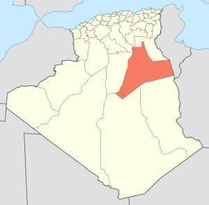 | |
| El Borma District | ||
| El Hadjira District | ||
| Hassi Messaoud District | ||
| Mégarine District | ||
| N'Goussa District | ||
| Sidi Khouïled District | ||
| Taïbet District | ||
| Témacine District | ||
| Touggourt District | ||