Megarine
| Megarine اﻟﻤﻘﺎرﻳﻦ | |
|---|---|
| Commune and town | |
 Megarine | |
| Coordinates: DZ 33°11′40″N 6°5′40″E / 33.19444°N 6.09444°ECoordinates: DZ 33°11′40″N 6°5′40″E / 33.19444°N 6.09444°E | |
| Country |
|
| Province | Ouargla Province |
| District | Mégarine District |
| Elevation | 68 m (223 ft) |
| Population (2008)[1] | |
| • Total | 13,751 |
| Time zone | CET (UTC+1) |
Megarine (Arabic: اﻟﻤﻘﺎرﻳﻦ) is a town and commune in Ouargla Province, Algeria, located just north of the city of Touggourt. According to the 2008 census it has a population of 13,751,[1] up from 10,996 in 1998,[2] and an annual growth rate of 2.3%.[1]
Geography
Megarine lies in a large area of palm plantations on an oasis network that extends from Sidi Slimane past Touggourt through to Balidat Ameur. Beyond the oases is the arid and barren landscape of the Sahara, featuring areas of sand dunes (ergs) and flat rocky plains (regs).
Climate
Megarine has a hot desert climate (Köppen climate classification BWh), with very hot summers and mild winters. Rainfall is light and sporadic, and summers are particularly dry.
Transportation
Megarine is connected to the N3 national highway a short 2.5 kilometres (1.6 mi) long local road. From the intersection, the town is connected to Biskra to the north, and Touggourt 9 kilometres (5.6 mi) to the south.
The train line from Biskra to Touggourt also runs near the town at the junction of the local road with the N3. While there is no station here, there is a station in Touggourt.
Education
6.4% of the population has a tertiary education, and another 16.9% has completed secondary education.[3] The overall literacy rate is 80.6%, and is 87.5% among males and 74.1% among females.[4]
Localities
The commune is composed of five localities:[5]
- Meggarine Djedida
- Meggarine Guedima
- Amiche
- El Ksour
- Ghamra
References
- 1 2 3 "Population: Ouargla Wilaya" (PDF) (in French). Office National des Statistiques Algérie. Retrieved 24 February 2013.
- ↑ Statoids
- ↑ "Structure relative de la population résidente des ménages ordinaires et collectifs âgée de 6 ans et plus selon le niveau d'instruction et la commune de résidence." (PDF) (in French). Office National des Statistiques Algérie. Retrieved 13 February 2013.
- ↑ "Taux d'analphabétisme et taux d'alphabétisation de la population âgée de 15 ans et plus, selon le sexe et la commune de résidence ." (PDF) (in French). Office National des Statistiques Algérie. Retrieved 13 February 2013.
- ↑ "Décret n° 84-365, fixant la composition, la consistance et les limites territoriale des communes. Wilaya d'El Oued" (PDF) (in French). Journal officiel de la République Algérienne,. 19 December 1984. p. 1551. Archived from the original (PDF) on 2 March 2013 or before. Retrieved 2 March 2013. Check date values in:
|archive-date=(help)
 |
M'Rara (El Oued) El Har Ihira |
Biskra Djamaa (El Oued) Sidi Slimane |
Meggarine Guedima | |
| |
El Oued | |||
| ||||
| | ||||
| Ouargla | Touggourt Hassi Messaoud |
Taibet |
Capital: Ouargla | ||
| Ouargla District | 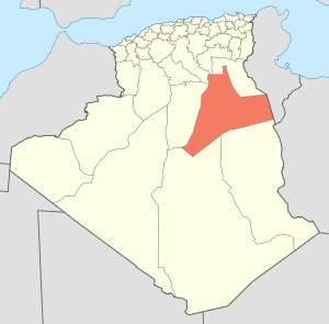 | |
| El Borma District | ||
| El Hadjira District | ||
| Hassi Messaoud District | ||
| Mégarine District | ||
| N'Goussa District | ||
| Sidi Khouïled District | ||
| Taïbet District | ||
| Témacine District | ||
| Touggourt District | ||