Mount Tate
| Mount Tate | |
|---|---|
| 立山 | |
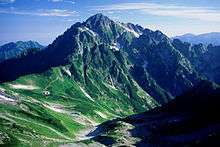
 Mount Tate (Mt. Fuji-no-Oritate, Mt. Oonanji, Mt. O) and Mikuri Pond | |
| Highest point | |
| Elevation | 3,015 m (9,892 ft) [1] |
| Listing |
List of mountains in Japan 100 Famous Japanese Mountains |
| Coordinates | 36°34′33″N 137°37′11″E / 36.57583°N 137.61972°ECoordinates: 36°34′33″N 137°37′11″E / 36.57583°N 137.61972°E [1] |
| Naming | |
| Translation | Standing Mountain (Japanese) |
| Geography | |
 Mount Tate Location in Japan | |
| Location | Toyama Prefecture, Japan |
| Parent range | Hida Mountains |
| Topo map |
Geospatial Information Authority 25000:1 剱岳[1] 50000:1 立山 |
| Climbing | |
| First ascent | Saeki no Ariyori ca. 8th century |
Mount Tate (立山 Tate-yama, IPA: [tate]) (commonly referred to as simply Tateyama) is located in the southeastern area of Toyama Prefecture, Japan. It is one of the tallest peaks in the Hida Mountains at 3,015 m (9,892 ft) and, along with Mount Fuji and Mount Haku, it is one of Japan's "Three Holy Mountains" (三霊山 Sanreizan). Strictly speaking, Tateyama itself is the popular term for the mountain comprising of the three peaks, Ōnanjiyama (大汝山, 3,015m), Oyama (雄山, 3,003m), and Fuji-no-Oritateyama (富士ノ折立, 2,999m),[2] and does not exist as a single peak.[3] Tateyama is the tallest mountain in the Tateyama Mountain Range (立山連峰, Tateyama-renpō).
The climbing season for Tateyama is from April until November. It was first climbed by Saeki no Ariyori during Japan's Asuka period. The area was designated the Chūbu-Sangaku National Park on December 4, 1934.[4][5]
Name
The kanji for the mountain (立山 Tateyama), which is called Tateyama in Japanese, mean "standing 立 or outstanding 顕" and "mountain," respectively. The pronunciation of tate is two syllables similar to tah-tei rather than gate. The Toyama Prefectural Government uses the name Mount Tateyama as an official translation of the Japanese mountain (although it is redundant, "Mount Mount Tate") because it shares its name with the neighboring town of Tateyama . English-speaking locals tend to use the Japanese name Tateyama when referring to the mountain.
Geology
The mountain is composed primarily of granite and gneiss. However, located along the ridge and plateau about 2 km (1.2 mi) west of the summit is a small andesite-dacite stratovolcano, confusingly also named Tateyama after its far more famous neighbor.[6] This volcano has an elevation of 2,621 m (8,599 ft), and has had minor historical eruptions, the latest in 1839.
Geography
Location
Tateyama is located in southeastern Toyama Prefecture. At the base of the mountain is the town of Tateyama, which is accessible by train from the prefecture's capital city, Toyama. Public transportation will take climbers and tourists as far as the Murodo Plateau Station at an altitude of 2,450 m (8,038 ft), from where individuals may climb to the peak on foot. There are glaciers only in Japan.
Mountain sights
Located by the Oyama peak is Oyama Shrine, where climbers can receive a blessing and warm sake from a priest. There is also a rest area where climbers may buy food, drinks, and souvenirs. This peak is better known but it is some way from the highest point of the mountain (Onanjiyama).
Located on the Murodo Plateau is a shopping area and onsen bath. The onsen on Tateyama is famously known for its use of sulfur spring water for the bath, leaving a noticeable aroma that can be detected even while ascending the mountain.
On clear days, climbers can see Shōmyō Falls (the tallest waterfall in Japan) across the valley while traveling along the main road from Tateyama Station to the Murodo Plateau.
From April to June, you can enjoy the beautiful snow walls named Yukino-ōtani, which is about 15–20 meters high.There are many charter service from Taipei, Inchon and Thailand during the high season.
Communications
Climbing 3015m high Tateyama is only one day trip. Tateyama Kurobe Alpine Route is available for personal use and sightseeing buses from Toyama Station are also available for group tourism.
From Toyama to Tateyama Station (Toyama) by Toyama Chihō Railway Tateyama Line, then to Bijodaira Station by Tateyama Cable Car, you can climb up to 2450m high Murodō Station by shuttle bus of Tateyama Kurobe Alpine Route, approximately 3 hours in total. During summer, shuttle buses between Toyama and Murodō are available. 2 hours walk to Tateyama summit takes you to the beautiful sight of Japanese Alps. From the top of the mountain, you can enjoy the view of Mt. Fuji on a fine day. Note that you must wear something to warm your body even in summer and the heavy duty shoes to climb.
If you want to watch the sunrise from the top, you can stay at Ichinokoshi Sanso(mountain lodge), which you can arrive at with 1 hour walk from Murodō.
Nearby mountains
| Image | Mountain | Elevation | Distance and direction from the Top |
Note |
|---|---|---|---|---|
 |
Mt. Tsurugi 剱岳 |
2,999 m (9,839 ft) | 5.3 km (3.3 mi) North |
100 Famous Japanese Mountains |
 |
Mt. Bessan 別山 |
2,880 m (9,449 ft) | 2.4 km (1.5 mi) North |
|
 |
Mt. Tate 立山 |
3,015 m (9,892 ft) | 0 km (0.0 mi) | 100 Famous Japanese Mountains the tallest mountain in Toyama Prefecture |
 |
Mt. Ryuō 龍王岳 |
2,872 m (9,423 ft) | 1.7 km (1.1 mi) Southwest |
|
 |
Mt. Harinoki 針ノ木岳 |
2,820.60 m (9,254 ft) | 7.2 km (4.5 mi) Southeast |
200 Famous Japanese Mountains |
 |
Mt. Akaushi 赤牛岳 |
2,864.23 m (9,397 ft) | 12.8 km (8.0 mi) South |
200 Famous Japanese Mountains |
 |
Mt. Yakushi 薬師岳 |
2,926.01 m (9,600 ft) | 13.7 km (8.5 mi) Southwest |
100 Famous Japanese Mountains |
Rivers
The mountain is the source of the following rivers, each of which flows to the Sea of Japan.[7]
- Hayatsuki River
- Tsurugisawa, tributaries of the Kurobe River
Scenery of Tateyama
 |
 |
 |
 |
| Tateyama from Higashi-Ichinokoshi |
Tateyama from Mt. Bessan |
Tateyama and Mt. Tsurugi from Mt. Jii |
Tateyama and Mt. Tsurugi from Mt. Asahi |
References
- 1 2 3 "Map inspection service" (in Japanese). Geospatial Information Authority of Japan,(高山-立山-剱岳). Retrieved January 28, 2011.
- ↑ http://maps.gsi.go.jp/#15/36.575910/137.619592/&base=std&ls=std&disp=1&vs=c1j0l0u0f0
- ↑ http://police.pref.toyama.jp/cms_sec_police/6112/kj00016326.html
- ↑ "Chūbu-Sangaku National Park". Ministry of the Environment (Japan). Retrieved January 28, 2011.
- ↑ http://www.gsi.go.jp/KOKUJYOHO/MOUNTAIN/mountain.html
- ↑ "Tate-yama". Global Volcanism Program. Smithsonian Institution.
- ↑ Mountain and plateau map of Mount Tsurugi and Tateyama (in Japanese). Shobunsha Publications,ISBN 978-4-398-75716-6. 2010.
See also
- Chūbu-Sangaku National Park
- Japanese Alps
- List of mountains in Japan
- Three-thousanders (in Japan)
- Tateyama Kurobe Alpine Route
- Tateyama Sabō Erosion Control Works Service Train
| Wikimedia Commons has media related to Mount Tate. |