Mount Talbert
| Mount Talbert | |
|---|---|
 | |
| Highest point | |
| Elevation | 740+ ft (226+ m) NGVD 29[1] |
| Prominence | 410 ft (120 m) [1] |
| Coordinates | 45°25′36″N 122°33′06″W / 45.4267871°N 122.5517579°WCoordinates: 45°25′36″N 122°33′06″W / 45.4267871°N 122.5517579°W [2] |
| Geography | |
 Mount Talbert | |
| Parent range | Cascade Range |
| Topo map | USGS Gladstone |
| Geology | |
| Volcanic arc/belt | Boring Lava Field |
| Last eruption | 500,000 years ago [3] |
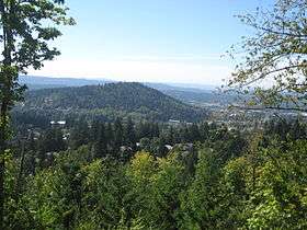
Mount Talbert is an volcanic cinder cone in Clackamas County, Oregon. It is part of the Boring Lava Field,[3] a zone of ancient volcanic activity in the area around Portland. Its summit rises to an elevation of 740+ feet (226+ m).
The butte remains undeveloped and is the location of a nature park of the same name which is managed by North Clackamas Parks and Recreation. The park has several interlinked hiking trails, along which there are several interpretive signs about the area's natural resources.
References
External links
This article is issued from Wikipedia - version of the 9/3/2016. The text is available under the Creative Commons Attribution/Share Alike but additional terms may apply for the media files.