Hat Rock State Park
| Hat Rock State Park | |
|---|---|
|
Hat Rock | |
 | |
| Type | Public, state |
| Location | Umatilla County, Oregon |
| Nearest city | Hermiston |
| Coordinates | 45°54′53″N 119°09′54″W / 45.9148548°N 119.1650109°WCoordinates: 45°54′53″N 119°09′54″W / 45.9148548°N 119.1650109°W[1] |
| Operated by | Oregon Parks and Recreation Department |

Hat Rock State Park is a state park in the U.S. state of Oregon, administered by the Oregon Parks and Recreation Department. The park is located off the east side of U.S. Highway 730 in Hermiston,[2] on the south shore of Lake Wallula behind McNary Dam on the Columbia River.[3]
Flood basalt
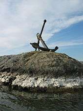
Anchor, a landmark in the Park
See also: Columbia River Basalt Group
Hat Rock is a geological formation that, along with another outcropping rock in the park called Boat Rock, are thought to be exposed remnants of a 12-million-year-old basalt flow. Floods from the Ice Age eventually left these bedrocks, as well as others along the Columbia River Gorge exposed at the surface of the Earth.[4] It is 70 feet (21 meters) high.
See also
References
- ↑ "Hat Rock State Park". Geographic Names Information System. United States Geological Survey. Retrieved 2011-06-21.
- ↑ Fanselow, Julie (2003). Traveling the Lewis and Clark Trail. Falcon. p. 252. ISBN 0-7627-2589-3.
- ↑ "McNary Dam and Lake Wallula". U.S. Army Corps of Engineers. Retrieved July 18, 2014.
- ↑ Bannan., Jan Gumprecht (2002). Oregon State Parks. Mountaineers Books. p. 212. ISBN 0-89886-794-0.
External links
- "Hat Rock State Park". Oregon Parks and Recreation Department. Retrieved 2011-06-21.
This article is issued from Wikipedia - version of the 11/13/2016. The text is available under the Creative Commons Attribution/Share Alike but additional terms may apply for the media files.