Mount Rose (Nevada)
| Mount Rose | |
|---|---|
 | |
| Highest point | |
| Elevation | 10,785 ft (3,287 m) NAVD 88[1] |
| Prominence | 3,630 ft (1,106 m) [2] |
| Listing |
|
| Coordinates | 39°20′38″N 119°55′04″W / 39.343777756°N 119.917888594°WCoordinates: 39°20′38″N 119°55′04″W / 39.343777756°N 119.917888594°W [1] |
| Geography | |
 Mount Rose Nevada, U.S. | |
| Location | Washoe County, Nevada, U.S. |
| Parent range | Carson Range |
| Topo map | USGS Mount Rose |
| Climbing | |
| Easiest route | Mount Rose Trail from Mount Rose Summit on Nevada State Route 431 |
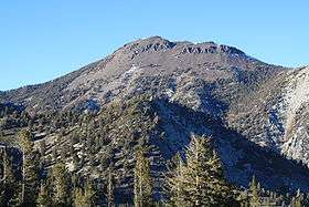
Mount Rose is the highest mountain in Washoe County, within the Carson Range of Nevada, United States. It ranks thirty-seventh among the most topographically prominent peaks in the state.[5] It is also both the highest and most topographically prominent peak of the greater Sierra Nevada range within the state of Nevada, and the third most topographically prominent peak in the Sierra Nevada overall. It is located in the Mount Rose Wilderness of the Humboldt-Toiyabe National Forest. An extinct volcano,[6] the mountain is in between Lake Tahoe and Reno.[7] State Route 431 traverses Mount Rose Summit southeast of Mount Rose.[7] Due to the high elevation, most of the precipitation that falls on the mountain is snow.[8] The view from Mount Rose, facing east is the Truckee Meadows area is the second largest population center in Nevada.
Mount Rose Ski Tahoe is nearby but is not on Mount Rose. Despite the name, the resort is actually on the slopes of Slide Mountain, which is on the other side of Nevada State Route 431.[9] The east slope of Slide Mountain, is the East Bowl of Mt. Rose. In 1964, the north side of Slide Mountain was named Mount Rose Ski Area and Reno Ski Bowl was renamed Slide Mountain Ski Area. In 1987 the two ski areas merged and began operation as one resort named Mt. Rose.[10]
Dr. James Edward Church of the University of Nevada established the Mount Rose Weather Observatory, one of America's first high-altitude meteorological observatories, on June 29, 1905.[11][12]
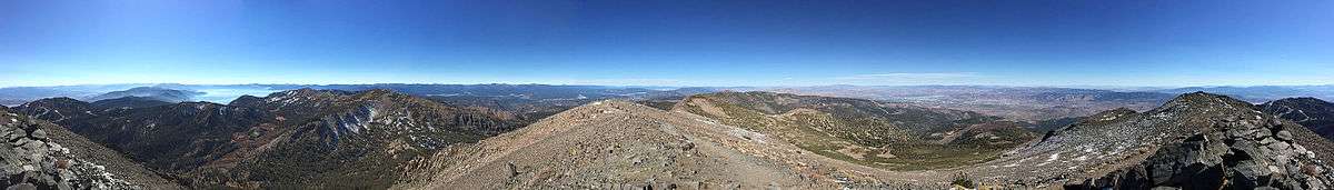
Summit panorama
Climate
| Climate data for Mount Rose, Nevada (station elevation 7,500ft) | |||||||||||||
|---|---|---|---|---|---|---|---|---|---|---|---|---|---|
| Month | Jan | Feb | Mar | Apr | May | Jun | Jul | Aug | Sep | Oct | Nov | Dec | Year |
| Record high °F (°C) | 55 (13) |
58 (14) |
67 (19) |
68 (20) |
79 (26) |
82 (28) |
89 (32) |
88 (31) |
83 (28) |
77 (25) |
65 (18) |
58 (14) |
89 (32) |
| Average high °F (°C) | 37.0 (2.8) |
36.9 (2.7) |
36.9 (2.7) |
42.0 (5.6) |
55.6 (13.1) |
66.8 (19.3) |
75.0 (23.9) |
75.5 (24.2) |
67.0 (19.4) |
54.2 (12.3) |
43.0 (6.1) |
39.5 (4.2) |
52.5 (11.4) |
| Average low °F (°C) | 18.6 (−7.4) |
17.8 (−7.9) |
19.5 (−6.9) |
23.2 (−4.9) |
33.2 (0.7) |
41.0 (5) |
46.4 (8) |
47.6 (8.7) |
40.7 (4.8) |
32.1 (0.1) |
23.8 (−4.6) |
21.7 (−5.7) |
30.5 (−0.8) |
| Record low °F (°C) | −10 (−23) |
−2 (−19) |
−5 (−21) |
4 (−16) |
13 (−11) |
20 (−7) |
27 (−3) |
31 (−1) |
21 (−6) |
14 (−10) |
1 (−17) |
−5 (−21) |
−10 (−23) |
| Average precipitation inches (mm) | 5.51 (140) |
4.90 (124.5) |
5.07 (128.8) |
2.11 (53.6) |
0.91 (23.1) |
0.55 (14) |
0.56 (14.2) |
0.91 (23.1) |
1.28 (32.5) |
1.67 (42.4) |
3.10 (78.7) |
4.03 (102.4) |
30.60 (777.2) |
| Average snowfall inches (cm) | 16.8 (42.7) |
37.1 (94.2) |
43.0 (109.2) |
4.7 (11.9) |
0 (0) |
0.4 (1) |
0 (0) |
0 (0) |
0.1 (0.3) |
2.3 (5.8) |
2.3 (5.8) |
9.9 (25.1) |
116.6 (296.2) |
| Source: The Western Regional Climate Center[13] | |||||||||||||
John Brayshaw Kaye, a poet, lawyer and politician, wrote a poem called Mount Rose
See also
References
- 1 2 "Mt Rose". NGS data sheet. U.S. National Geodetic Survey. Retrieved 2008-11-23.
- 1 2 "Mount Rose, Nevada". Peakbagger.com. Retrieved 2011-05-19.
- ↑ "Great Basin Peaks List". Toiyabe Chapter, Sierra Club. Retrieved 2016-08-12.
- ↑ "Sierra Peaks Section List" (PDF). Angeles Chapter, Sierra Club. Retrieved 2016-08-12.
- ↑ "Nevada Peaks with 2000 feet of Prominence". Peakbagger.com. Retrieved 2014-10-23.
- ↑ "Lake Tahoe Facts, Natural History, & Human History". Tahoe Adventure Sports. Retrieved 2009-09-25.
- 1 2 "Google Maps". Google. Retrieved 2008-04-05.
- ↑ "Subsection M261Et - Carson Range". USDA, Forest Service. Archived from the original on 2007-08-13. Retrieved 2014-01-28.
- ↑ Joseph V. Tingley; Becky Weimer Purkey; University of Nevada, Reno (1 January 2005). Geologic and Natural History Tours in the Reno Area. NV Bureau of Mines & Geology. p. 98. ISBN 978-1-888035-09-4. Retrieved 8 April 2012.
- ↑ "Tahoe Resorts A to Z". TahoeeTopia. Retrieved 2014-01-04.
- ↑ "HM 230, Mount Rose Weather Observatory". Nevada Landmarks. Retrieved 2011-05-19.
- ↑ Church, J.E., Jr. (June 1908). "Mount Rose Weather Observatory". Agricultural Experiment Station the University of Nevada. 67: 7. Retrieved 2009-07-21.
- ↑ "Seasonal Temperature and Precipitation Information". Western Regional Climate Center. Retrieved 2013-11-18.
External links
- "Mount Rose". Geographic Names Information System. United States Geological Survey.
- "Mount Rose (Nevada)". SummitPost.org.
- "Mount Rose snow sampler". The Glossary of Meteorology. The first instrument for measuring snow water content. It is still in use today.