Montana Highway 87
| ||||
|---|---|---|---|---|
| Route information | ||||
| Maintained by MDT | ||||
| Length: | 8.571 mi[1] (13.794 km) | |||
| Existed: | October 9, 1922[2] – present | |||
| Major junctions | ||||
| South end: |
| |||
| North end: |
| |||
| Location | ||||
| Counties: | Madison | |||
| Highway system | ||||
| ||||

Montana Highway 87 (MT 87) is a primary state highway located in the southwestern region of the U.S. state of Montana. The highway travels through mainly rural areas in Raynolds Pass, from the Montana–Idaho state line to an intersection with U.S. Route 287 (US 287). The route travels through a portion of Gallatin National Forest. In 1922, a road in the location of MT 87 was added to the highway system, and a few years later the road was designated as portions of two early auto trails. In 1959, the route was rapidly improved due to the collapse of US 287 nearby. During 1967, much of the highway was reconstructed along its current location.
Route description
MT 87 begins at the Montana–Idaho state line, traveling through Raynolds Pass. The highway proceeds northward, intersecting a small road before entering rural areas within Gallatin National Forest. The route continues northeast, intersecting several forest roads before bending northwestward. The route intersects several small roads while it runs parallel to a small creek. It crosses over the Madison River after passing several small buildings. The highway continues northwestward to its northern terminus, an at-grade intersection with US 287. The highway is maintained by the Montana Department of Transportation (MDT).[3][4] Part of the job of the MDT is to measure traffic along the highway. These counts are taken using a metric called annual average daily traffic (AADT). This is a statistical calculation of the average daily number of vehicles that travel along a portion of the highway. In 2011, the highway had an AADT count of 583 vehicles.[5] No portion of the highway is listed as part of the National Highway System (NHS),[6] a network of roads important to the country's economy, defense, and mobility.[7]
History
On October 9, 1922, a road located in the general location of MT 87 was added to the Montana State Highway system.[2] By at least 1924, an auto trail known as the Banff Grand Canyon Road ran along the highway in the general location of MT 87.[8] The next year, the highway had been given a graded dirt surface, and was designated as part of the Great White Way auto trail, as well as the Banff Grand Canyon Road.[9] Between 1925 and 1927, the auto trail designations were removed from the stretch of highway near present-day MT 87.[10] By 1937, the main highway had been shifted north of the location of MT 87, and had been numbered as State Highway 1. A road remained in the location of MT 87, although it was unnumbered. This road had also been extended several miles northward to Lyon.[11]
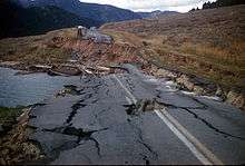
By 1951, the highway had been reconstructed generally along MT 87's present location, and it had been upgraded to an improved gravel road.[12] In 1959, the road in the location of MT 87 was rapidly improved in order to serve as an alternate routing to U.S. Route 287. Portions of US 287 around Hebgen Lake collapsed and crumbled as a result of the 1959 Hebgen Lake earthquake. After US 287 was fixed, the highway's importance decreased.[13][14] In 1962, the portions of the highway from the southern terminus to present-day milepost 8.395 were reconstructed along the current location. In 1967, the rest of the highway was reconstructed along the present location.[1] By 1987, the highway had been numbered as MT 87. The route had also been paved.[15]
Major intersections
| County | Location | mi[1] | km | Destinations | Notes |
|---|---|---|---|---|---|
| Fremont | | Continuation into Idaho | |||
| Raynolds Pass | 0.000 | 0.000 | Idaho–Montana state line | ||
| Madison | | 8.571 | 13.794 | ||
| 1.000 mi = 1.609 km; 1.000 km = 0.621 mi | |||||
References
- Footnotes
- 1 2 3 Montana Road Log, p. 141
- 1 2 Montana Road Log, p 102
- ↑ Google (July 1, 2013). "Overview Map of Montana Highway 87" (Map). Google Maps. Google. Retrieved July 1, 2013.
- ↑ The Road Atlas (Map). 1 in:30 mi. Cartography by Rand McNally. Rand McNally. 2009. p. 60. § K8-L8. ISBN 0-528-94200-X.
- ↑ Montana Traffic Flow Map (PDF) (Map) (2011 ed.). Cartography by Traffic Data Collection Section. Montana Department of Transportation. 2011. Retrieved July 1, 2013.
- ↑ National Highway System: Montana (PDF) (Map). Federal Highway Administration. March 2005. Retrieved July 1, 2013.
- ↑ Slater, Rodney E. (Spring 1996). "The National Highway System: A Commitment to America's Future". Public Roads. Washington, DC: Federal Highway Administration. 59 (4). ISSN 0033-3735. Retrieved June 26, 2013.
- ↑ Auto Trails Map: District No. 13 (Map) (1924 ed.). 1 inch=5 miles. Cartography by Rand McNally and Company. Rand McNally and Company. 1924. § ER–RT. OCLC 742004352.
- ↑ Auto Trails map Idaho–Montana-Wyoming (Map) (1925 ed.). 1 inch=5 miles. Cartography by Rand McNally and Company. Rand McNally and Company. 1925. § G8. OCLC 289456074.
- ↑ Junior Auto Road Map Montana (Map) (1927 ed.). 1 inch=10 miles. Cartography by Rand McNally and Company. Rand McNally and Company. 1927. § G5.
- ↑ Idaho, Montana, Wyoming (Map) (1937 ed.). 1 inch=28 miles. Cartography by Rand McNally. Texaco. 1937. § G7–H7. OCLC 52950564.
- ↑ Highway Map of Montana (Map) (1951 ed.). 1 inch=26 miles. Cartography by H.M. Gousha Company. Shell Oil. 1951. § F7–G7. OCLC 695396080.
- ↑ Healy, Donna (1999). "40 years after the Hebgen Lake earthquake". The Billings Gazette. OCLC 12530130. Archived from the original on 2007-07-07. Retrieved November 12, 2012.
- ↑ Christopherson, Edmund (1960). The Night the Mountain Fell: The Story of the Montana-Yellowstone Earthquake. Missoula, MT: Lawton Printing Inc. ISBN 116381802X.
- ↑ Montana (Map) (1987 ed.). 1:500,000. Cartography by United States Geological Survey. Allan Cartography. 1987. § C.
- Bibliography
- Staff (2011). Montana Road Log (PDF) (Report) (2011 ed.). Montana Department of Transportation. Retrieved July 1, 2013.