Minerve, Hérault
| Minerve | ||
|---|---|---|
|
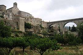
The bridge at Minerve | ||
| ||
 Minerve | ||
|
Location within Occitanie region  Minerve | ||
| Coordinates: 43°21′17″N 2°44′50″E / 43.3547°N 2.7472°ECoordinates: 43°21′17″N 2°44′50″E / 43.3547°N 2.7472°E | ||
| Country | France | |
| Region | Occitanie | |
| Department | Hérault | |
| Arrondissement | Béziers | |
| Canton | Olonzac | |
| Intercommunality | Minervois | |
| Government | ||
| • Mayor (2008–2014) | Didier Vordy | |
| Area1 | 27.89 km2 (10.77 sq mi) | |
| Population (2008)2 | 122 | |
| • Density | 4.4/km2 (11/sq mi) | |
| Time zone | CET (UTC+1) | |
| • Summer (DST) | CEST (UTC+2) | |
| INSEE/Postal code | 34158 / 34210 | |
| Elevation |
137–604 m (449–1,982 ft) (avg. 227 m or 745 ft) | |
|
1 French Land Register data, which excludes lakes, ponds, glaciers > 1 km² (0.386 sq mi or 247 acres) and river estuaries. 2 Population without double counting: residents of multiple communes (e.g., students and military personnel) only counted once. | ||

Minerve (Occitan: Menèrba) is a commune in the Hérault department in the Occitanie region in southern France.

History
In 1210 a group of Cathars sought refuge in the village after the massacre at Béziers during the Albigensian Crusade. The village was besieged by Simon de Montfort, Viscount of Albi and Carcassonne. The attacking army besieged the village for six weeks before it surrendered. Four catapults or trebuchets were set up around the ramparts, three to attack the village itself and the largest, known as Malvoisine or "bad neighbour", to destroy the town's well. With the town's only water supply cut off, the Commander of the 200-strong garrison, Viscount Guilhem of Minerve, gave in and negotiated a surrender in order to have the villagers and himself spared from death. However, 140 Cathars refused to give up their faith and convert, being burned to death at the stake on 22 July.
Geography
The village is situated on top of the gorge of the River Cesse in a naturally strong defensive position. Near the village the river disappears underground in a large, naturally-carved tunnel.
Pictures
 Minerve
 Minerve
 Minerve
 Minerve
 Minerve
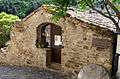 Minerve
 Minerve
 Minerve
Population
| Historical population | ||
|---|---|---|
| Year | Pop. | ±% |
| 1793 | 250 | — |
| 1800 | 226 | −9.6% |
| 1806 | 285 | +26.1% |
| 1821 | 276 | −3.2% |
| 1831 | 309 | +12.0% |
| 1836 | 357 | +15.5% |
| 1841 | 395 | +10.6% |
| 1846 | 403 | +2.0% |
| 1851 | 403 | +0.0% |
| 1856 | 386 | −4.2% |
| 1861 | 350 | −9.3% |
| 1866 | 326 | −6.9% |
| 1872 | 289 | −11.3% |
| 1876 | 266 | −8.0% |
| 1881 | 265 | −0.4% |
| 1886 | 246 | −7.2% |
| 1891 | 261 | +6.1% |
| 1896 | 240 | −8.0% |
| 1901 | 240 | +0.0% |
| 1906 | 225 | −6.2% |
| 1911 | 235 | +4.4% |
| 1921 | 240 | +2.1% |
| 1926 | 204 | −15.0% |
| 1931 | 213 | +4.4% |
| 1936 | 217 | +1.9% |
| 1946 | 189 | −12.9% |
| 1954 | 166 | −12.2% |
| 1962 | 138 | −16.9% |
| 1968 | 125 | −9.4% |
| 1975 | 106 | −15.2% |
| 1982 | 112 | +5.7% |
| 1990 | 104 | −7.1% |
| 1999 | 111 | +6.7% |
| 2008 | 122 | +9.9% |
Miscellaneous
Minerve has been selected as one of Les Plus Beaux Villages de France ("The Most Beautiful Villages Of France"). Historically, the village has been the capital of the Minervois wine region. The main bridge leading into the village is closed to all passenger vehicles not owned by residents of Minerve. Of all of the original fortifications, only a slender octagonal tower, known locally as the Candela, survives.
See also
References
External links
| Wikimedia Commons has media related to Minerve (Hérault). |