Arrondissement of Béziers
| Béziers | |
|---|---|
| Arrondissement of France | |
 | |
| Country | France |
| Region | Occitanie |
| Department | Hérault |
| Communes | 152 |
| Subprefecture | Béziers |
| Area¹ | |
| • Total | 2,987 km2 (1,153 sq mi) |
| Population (2013) | |
| • Total | 308,948 |
| • Density | 100/km2 (270/sq mi) |
| ¹ French Land Register data, which exclude lakes, ponds, and glaciers larger than 1 km² as well as the estuaries of rivers. | |
The arrondissement of Béziers is an arrondissement of France in the Hérault department in the Occitanie région. Its INSEE code is 341 and its capital city is Béziers.
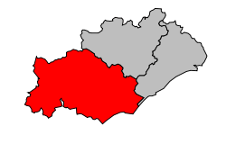
It is the southernmost and largest of the arrondissements of the department, with an area of 2,986.8 km2 (1,153.2 sq mi).[1] In 2012, it has 304,108 inhabitants and a density of 101.8 inhabitants/km².[2]
The main cities, with more than 6,000 inhabitants in 2012, in the arrondissement are Béziers (72,970 inhabitants), Agde (24,651 inhabitants), Pézenas (8,317 inhabitants), Marseillan (7,884 inhabitants), Sérignan (6,836 inhabitants) and Bédarieux (6,297 inhabitants).[2]
History
When the Hérault department was created on 17 February 1800, the arrondissement of Béziers was part of that original department.[3]
Geography
The arrondissement of Béziers is bordered to the north by the Aveyron department and the arrondissement of Lodève, to the northeast by the arrondissement of Montpellier, to the east by the Gulf of Lyon (Mediterranean Sea), to the south by the Aude department and to the west by the Tarn department.
Composition
Cantons
The cantons of the arrondissement of Béziers are:
- Agde
- Béziers-1
- Béziers-2
- Béziers-3
- Cazouls-lès-Béziers
- Clermont-l'Hérault (partly)
- Mèze (partly)
- Pézenas
- Saint-Pons-de-Thomières
Communes
The arrondissement of Béziers has 152 communes; they are (with their INSEE codes):
| 1. Abeilhan (34001) | 2. Adissan (34002) | 3. Agde (34003) | 4. Agel (34004) |
| 5. Aigne (34006) | 6. Aigues-Vives (34007) | 7. Alignan-du-Vent (34009) | 8. Assignan (34015) |
| 9. Aumes (34017) | 10. Autignac (34018) | 11. Azillanet (34020) | 12. Babeau-Bouldoux (34021) |
| 13. Bassan (34025) | 14. Beaufort (34026) | 15. Berlou (34030) | 16. Bessan (34031) |
| 17. Boisset (34034) | 18. Boujan-sur-Libron (34037) | 19. Bédarieux (34028) | 20. Béziers (34032) |
| 21. Cabrerolles (34044) | 22. Cabrières (34045) | 23. Cambon-et-Salvergues (34046) | 24. Camplong (34049) |
| 25. Capestang (34052) | 26. Carlencas-et-Levas (34053) | 27. Cassagnoles (34054) | 28. Castanet-le-Haut (34055) |
| 29. Castelnau-de-Guers (34056) | 30. Causses-et-Veyran (34061) | 31. Caussiniojouls (34062) | 32. Caux (34063) |
| 33. Cazedarnes (34065) | 34. Cazouls-d'Hérault (34068) | 35. Cazouls-lès-Béziers (34069) | 36. Cers (34073) |
| 37. Cessenon-sur-Orb (34074) | 38. Cesseras (34075) | 39. Colombiers (34081) | 40. Colombières-sur-Orb (34080) |
| 41. Combes (34083) | 42. Corneilhan (34084) | 43. Coulobres (34085) | 44. Courniou (34086) |
| 45. Creissan (34089) | 46. Cruzy (34092) | 47. Cébazan (34070) | 48. Espondeilhan (34094) |
| 49. Faugères (34096) | 50. Ferrals-les-Montagnes (34098) | 51. Ferrières-Poussarou (34100) | 52. Florensac (34101) |
| 53. Fontès (34103) | 54. Fos (34104) | 55. Fouzilhon (34105) | 56. Fraisse-sur-Agout (34107) |
| 57. Félines-Minervois (34097) | 58. Gabian (34109) | 59. Graissessac (34117) | 60. Hérépian (34119) |
| 61. La Caunette (34059) | 62. La Livinière (34141) | 63. La Salvetat-sur-Agout (34293) | 64. La Tour-sur-Orb (34312) |
| 65. Lamalou-les-Bains (34126) | 66. Laurens (34130) | 67. Le Poujol-sur-Orb (34211) | 68. Le Pradal (34216) |
| 69. Le Soulié (34305) | 70. Les Aires (34008) | 71. Lespignan (34135) | 72. Lieuran-Cabrières (34138) |
| 73. Lieuran-lès-Béziers (34139) | 74. Lignan-sur-Orb (34140) | 75. Lézignan-la-Cèbe (34136) | 76. Magalas (34147) |
| 77. Maraussan (34148) | 78. Margon (34149) | 79. Marseillan (34150) | 80. Maureilhan (34155) |
| 81. Minerve (34158) | 82. Mons (34160) | 83. Montady (34161) | 84. Montagnac (34162) |
| 85. Montblanc (34166) | 86. Montels (34167) | 87. Montesquieu (34168) | 88. Montouliers (34170) |
| 89. Murviel-lès-Béziers (34178) | 90. Neffiès (34181) | 91. Nissan-lez-Enserune (34183) | 92. Nizas (34184) |
| 93. Nézignan-l'Évêque (34182) | 94. Olargues (34187) | 95. Olonzac (34189) | 96. Oupia (34190) |
| 97. Pailhès (34191) | 98. Pardailhan (34193) | 99. Pierrerue (34201) | 100. Pinet (34203) |
| 101. Poilhes (34206) | 102. Pomérols (34207) | 103. Portiragnes (34209) | 104. Pouzolles (34214) |
| 105. Prades-sur-Vernazobre (34218) | 106. Prémian (34219) | 107. Puimisson (34223) | 108. Puissalicon (34224) |
| 109. Puisserguier (34225) | 110. Péret (34197) | 111. Pézenas (34199) | 112. Pézènes-les-Mines (34200) |
| 113. Quarante (34226) | 114. Rieussec (34228) | 115. Riols (34229) | 116. Roquebrun (34232) |
| 117. Roquessels (34234) | 118. Rosis (34235) | 119. Roujan (34237) | 120. Saint-Chinian (34245) |
| 121. Saint-Geniès-de-Fontedit (34258) | 122. Saint-Geniès-de-Varensal (34257) | 123. Saint-Gervais-sur-Mare (34260) | 124. Saint-Jean-de-Minervois (34269) |
| 125. Saint-Julien (34271) | 126. Saint-Martin-de-l'Arçon (34273) | 127. Saint-Nazaire-de-Ladarez (34279) | 128. Saint-Pons-de-Mauchiens (34285) |
| 129. Saint-Pons-de-Thomières (34284) | 130. Saint-Thibéry (34289) | 131. Saint-Vincent-d'Olargues (34291) | 132. Saint-Étienne-Estréchoux (34252) |
| 133. Saint-Étienne-d'Albagnan (34250) | 134. Sauvian (34298) | 135. Servian (34300) | 136. Siran (34302) |
| 137. Sérignan (34299) | 138. Taussac-la-Billière (34308) | 139. Thézan-lès-Béziers (34310) | 140. Tourbes (34311) |
| 141. Usclas-d'Hérault (34315) | 142. Vailhan (34319) | 143. Valras-Plage (34324) | 144. Valros (34325) |
| 145. Vendres (34329) | 146. Verreries-de-Moussans (34331) | 147. Vias (34332) | 148. Vieussan (34334) |
| 149. Villemagne-l'Argentière (34335) | 150. Villeneuve-lès-Béziers (34336) | 151. Villespassans (34339) | 152. Vélieux (34326) |
External links
References
- ↑ "Arrondissement de Béziers (341) - Résumé statistique". Publications et statistiques pour la France ou les régions (in French). Institut national de la statistique et des études économiques - INSEE. Retrieved 6 August 2015.
- 1 2 "Populations lègales 2012 - 34-Hérault". Populations légales 2012 des départements et des collectivités d'outre-mer (in French). Institut national de la statistique et des études économiques - INSEE. Retrieved 6 August 2015.
- ↑ "Historique de l'Hérault". Le SPLAF (in French). Retrieved 6 August 2015.
Coordinates: 43°20′34″N 3°12′58″E / 43.34278°N 3.21611°E