Meadowbrook, Queensland
| Meadowbrook Logan City, Queensland | |||||||||||||
|---|---|---|---|---|---|---|---|---|---|---|---|---|---|
 Edeanlea Drive, 2013 | |||||||||||||
 Meadowbrook | |||||||||||||
| Coordinates | 27°40′S 153°9′E / 27.667°S 153.150°ECoordinates: 27°40′S 153°9′E / 27.667°S 153.150°E | ||||||||||||
| Population | 3,138 (2011 census)[1] | ||||||||||||
| Postcode(s) | 4131 | ||||||||||||
| Location | 27 km (17 mi) from Brisbane GPO | ||||||||||||
| LGA(s) | Logan City | ||||||||||||
| State electorate(s) | Waterford | ||||||||||||
| Federal Division(s) | |||||||||||||
| |||||||||||||
Meadowbrook is an urban, mixed use suburb of Logan City, Queensland, Australia. At the 2011 Australian Census the suburb recorded a population of 3,138.[1] It was split off from the larger suburb of Loganlea and named in 1991. The northern and eastern border of the suburb follow Logan River and part of its tributary Slacks Creek. The Gold Coast railway line marks the southern boundary.
The Loganlea Golf Course and Logan campus of Griffith University are located in Meadowbrook. Most of the gold course is within a defined flood zone as is Lake Elleslie at the entrance to the university. Logan Hospital is located in this suburb. The hospital is currently being upgrade with construction expeccted to be complete by 2015. There is also an industrial area in the west of Meadowbrook and a large section of housing surround the hospital and adjacent TAFE college. Meadowbrook is home to Riverdale Park, a former grazing property.[2]
A draft master plan for the suburb is being prepared by the Logan City Council.[3] Medowbrook has been designated as a Specialist Centre in the South East Queensland Regional Plan 2009-2031, dedicated to health, research and education.[4] Waterways of Slacks Creek dominate the northern sections of Meadowbrook with suburban arterical Loganlea Road heading towards the Pacific Motorway and Slacks Creek being the only road in the area. Power lines and an electrical substation have been built in the industrial area.
History
The suburb was formed in 1991 as a subdivision of Loganlea.[5] The Logan Hospital was opened in 1990 and the Logan campus for Griffith University and TAFE college opened in 1998.[6]
Riverdale Park
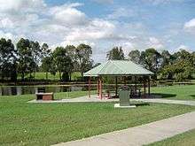
A long section of the Logan River stretching past Meadowbrook was once grazing lands. Today the flood prone area has been converted into a well-catered 10-hectare parklands. The parks entrance is in Armstrong Street. Cemented walking paths extends up Slacks Creek towards the Logan Motorway and Tanah Merah. There are two dog-off-leash sections, facilities for large groups, playground and exercise equipment.
Transport
The suburb is crossed by a number of major transport routes. These include the Logan Motorway, Loganlea railway station for both the Beenleigh railway line and Gold Coast railway line and Loganlea Road. The suburb is serviced by the 560 and 562 Translink bus services linking the suburb to Logan Central, Springwood, Browns Plains and the Logan Hyperdome. A number of bus routes services Meadowbrook and there are two established bikeways.
Problems with illegal car parking in the streets around the hospital, TAFE and train station were addressed with increased restriction of two-hour limited parking.[7]
Demographics
In the 2011 census, Meadowbrook recorded a population of 3,138 people, 51.1% female and 48.9% male.[1] The median age of the Meadowbrook population was 31 years, 6 years below the national median of 37. 61% of people living in Meadowbrook were born in Australia. The other top responses for country of birth were New Zealand 10.1%, England 4.8%, Philippines 1.8%, Fiji 1.1%, Malaysia 1%. 76.3% of people spoke only English at home; the next most common languages were 1.5% Hindi, 1.3% Mandarin, 1.2% Cantonese, 1.2% Vietnamese, 1.1% Tagalog.[1]
References
- 1 2 3 4 Australian Bureau of Statistics (31 October 2012). "Meadowbrook (State Suburb)". 2011 Census QuickStats. Retrieved 20 December 2013.
- ↑ "Riverdale Park". Parks Directory. Logan City Council. Retrieved 21 December 2013.
- ↑ "Meadowbrook". Structure Plans and Master Plans. Logan City Council. Retrieved 21 December 2013.
- ↑ "Structure Plans & Master Plans". Logan City Council. Retrieved 22 December 2013.
- ↑ Queensland Places: Loganlea. University of Queensland. Retrieved 20 December 2013.
- ↑ Howells, Mary. Logan Regional History (PDF). Logan City Council. pp. 98–99. Retrieved 21 December 2013.
- ↑ Heidi Braithwaite (10 May 2013). "Park restrictions around major Meadowbrook facilities will improve safety following an abundance of fines". www.couriermail.com.au. News Ltd. Retrieved 21 December 2013.
External links
| Wikimedia Commons has media related to Meadowbrook, Queensland. |