Daisy Hill, Queensland
| Daisy Hill Logan City, Queensland | |||||||||||||
|---|---|---|---|---|---|---|---|---|---|---|---|---|---|
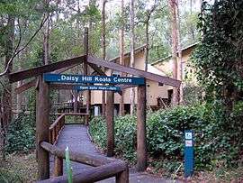 Daisy Hill Koala Centre, 2013 | |||||||||||||
| Population | 6,255 (2011 census)[1] | ||||||||||||
| Postcode(s) | 4127 | ||||||||||||
| Location | 24 km (15 mi) from Brisbane GPO | ||||||||||||
| LGA(s) | Logan City | ||||||||||||
| State electorate(s) | Springwood | ||||||||||||
| Federal Division(s) | Rankin | ||||||||||||
| |||||||||||||
Daisy Hill is a suburb of Logan City, Queensland, Australia. Part of the suburb's western boundary follows the Pacific Motorway. A large proportion of the Daisy Hill is protected by the Daisy Hill Conservation Park.
Demographics
In the 2011 census, Daisy Hill recorded a population of 6,255 people, 49.7% female and 50.3% male. The median age of the Daisy Hill population was 35 years, 2 years below the national median of 37. 65.5% of people living in Daisy Hill were born in Australia. The other top responses for country of birth were New Zealand 7.7%, England 6%, South Africa 1.5%, Scotland 1.1%, Republic of Korea 1.1%. 84.5% of people spoke only English at home; the next most common language was 1.1% Korean.
History
The Dennis family were first Europeans to settle at Daisy Hill. James Dennis immigrated in 1864 on the ship Flying Cloud. In 1867, he married Mary Ann Markwell.[2] Around 1870 they began selecting land in the now Daisy Hill area, eventually acquiring over 320 hectares (800 acres). They named the property Daisy Hill, supposedly because their daughters saw daisies growing on the hill.[3]
Other early pioneers were the Usher family, who grew grapes and made and sold wine.[3] Daisy Hill was once part of the Shire of Tingalpa.[4]
Heritage listings
Daisy Hill has a number of heritage-listed sites, including:
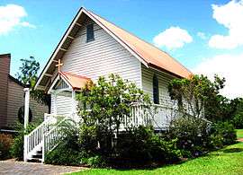
- 2 Boronia Drive: Old St Mark's Anglican Church[5]
Daisy Hill State Forest
The Daisy Hill State Forest was declared a timber reserve in 1874. In 1917 it was declared a State Forest[6] and in 1986 a State Forest Park. The forest was used for timber gathering, honey making, gold mining and grazing. In 2006, it was gazetted as Daisy Hill Conservation Park to be used for habitat conservation and recreation; it contains the Daisy Hill Koala Centre.[3] The park is considered to be one of the best mountain bike riding areas in Australia.[7]
A Reserve for Rifle Range was gazetted in 1901 from part of the west side of the original timber reserve. It was proposed for use by the Forest Rangers Rifle Club of Slacks Creek with a recommendation from the Queensland Defence Force. Initially the range consisted of 10 ha (25 acres), 1,010 by 100 metres (1,100 by 110 yards), with the line of fire terminated by a natural rise. The range was re-gazetted as reserve R.799 in 1902 with an increase in area towards and behind the targets for safety, forming a total area of around 50 ha (123 acres). In 1908, the military officer supervising rifle clubs in Queensland reported that the range was not then in use due to destruction of mantlets and targets by bush fire. The land was reinstated as part of the State Forest in 1952.[8]
Notable people
- Dami Im singer
References
- ↑ Australian Bureau of Statistics (31 October 2012). "Daisy Hill (State Suburb)". 2011 Census QuickStats. Retrieved 16 February 2014.
- ↑ Dennis Family Cemetery
- 1 2 3 Daisy Hill: Logan City Council. Retrieved 22 April 2014.
- ↑ Mary Howells. "Mount Cotton - a brief history" (PDF). Redland City Council. Archived from the original (PDF) on March 29, 2011. Retrieved 26 June 2014.
- ↑ "Old St Mark's Anglican Church (entry 602201)". Queensland Heritage Register. Queensland Heritage Council. Retrieved 10 July 2013.
- ↑ Daisy Hill: Queensland Places. University of Queensland. Retrieved 22 April 2014.
- ↑ Marissa Calligeros (22 April 2014). "Man dies after mountain bike crash". Brisbane Times. Fairfax Media. Retrieved 22 April 2014.
- ↑ Queensland State Archives Item ID144068, File - reserve
Further reading
Anderson, Judith; et al. (1995), Cultural heritage study of Daisy Hill State Forest Park : a report for the Queensland Department of Environment and Heritage
External links
![]() Media related to Daisy Hill, Queensland at Wikimedia Commons
Media related to Daisy Hill, Queensland at Wikimedia Commons
Coordinates: 27°38′S 153°10′E / 27.633°S 153.167°E