Massachusetts Route 57
| ||||
|---|---|---|---|---|
 | ||||
| Route information | ||||
| Length: | 45.42 mi (73.10 km) | |||
| Existed: | by 1930[1] – present | |||
| Major junctions | ||||
| West end: |
| |||
|
| ||||
| East end: |
| |||
| Location | ||||
| Counties: | Berkshire, Hampden | |||
| Highway system | ||||
| ||||

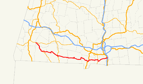
Route 57 is an east–west Massachusetts state route that runs from Monterey to Agawam. The eastern 5.0 miles[2] (8.1 km) in Agawam is a freeway that runs from Route 187 to the route's eastern terminus at U.S. Route 5.[3]
Route description

The route begins in Monterey, at its intersection with routes 23 and 183.[4] The section from there to New Marlborough (which is a concurrency with Route 183) primarily takes a southeastern path that passes several stretches of farmland.[3] In New Marlborough, Route 57 splits from Route 183 and follows a mainly easterly route with frequent curves, passing more farmland.[3] During this stretch, there is a brief concurrency with Route 8 in Sandisfield to cross the Farmington River's west branch.[5]
In Southwick, Route 57 starts to enter a more suburban area.[3] There are more concurrencies during this stretch, first with U.S. Route 202 and Massachusetts Route 10 in Southwick, and then with Route 187 in Agawam.[3]
When Route 57 splits off from Route 187, it becomes a freeway,[3] the Henry E. Bodurtha Highway.[2] It has five exits before terminating in a rotary that is served by an interchange from U.S. Route 5.[4]
History

Route 57 (which was formed by 1930[1]) initially went from Southwick to West Springfield.[1] It was extended to Sandisfield in the mid-1930s and Monterey in the late 1940s.[1]
Construction on the freeway portion began in 1958,[2] with the first portion (to today's Route 159,[1] then called Route 5A[6]) opening in 1961.[2] It was extended to past Route 75 in 1966, with Route 57 being moved to the freeway around this time (the old alignment became Route 147).[1] In 1991, work to extend the freeway to Route 187 began, with the new section opening in 1995.[2] A further extension to Southwick has been proposed, but it was put on hold by then-Governor Mitt Romney in June 2005; nevertheless, Agawam's city council continues to urge the state to construct the extension.[2] The MA 57 freeway exits do not have numbers, but this was scheduled to change during 2016 when all interchanges would be given milepost-based numbers between 40 and 45 as part of a statewide exit number conversion project.[7] However, this project now has been indefinitely postponed.[8]
Major intersections
| County | Location | mi | km | Destinations | Notes |
|---|---|---|---|---|---|
| Berkshire | Monterey | 0.0 | 0.0 | Northern terminus of concurrency with Route 183 | |
| New Marlborough | 6.0 | 9.7 | Southern terminus of concurrency with Route 183 | ||
| Sandisfield | 15.2 | 24.5 | 175-yard (160 m) concurrency with Route 8 | ||
| Hampden | Granville | 27.8 | 44.7 | Northern terminus of Route 189 | |
| Southwick | 34.3 | 55.2 | Southern terminus of concurrency with US 202 / Route 10 | ||
| 34.9 | 56.2 | Northern terminus of concurrency with US 202 / Route 10 | |||
| Agawam | 39.6 | 63.7 | Northern terminus of concurrency with Route 187 | ||
| 40.4 | 65.0 | Southern terminus of concurrency with Route 187 | |||
| 40.4 | 65.0 | Western terminus of the Henry E. Bodurtha Highway (freeway section) | |||
| 41.8 | 67.3 | Garden Street – Agawam | Westbound exit and eastbound entrance | ||
| 42.6 | 68.6 | Mill Street west – Feeding Hills | Westbound exit; eastbound entrance from Tennis Road | ||
| 43.1 | 69.4 | ||||
| 43.9 | 70.7 | Westbound exit and eastbound entrance | |||
| 45.0 | 72.4 | Editha Avenue | Westbound exit only | ||
| 45.4 | 73.1 | Rotary interchange | |||
1.000 mi = 1.609 km; 1.000 km = 0.621 mi
| |||||
References
- 1 2 3 4 5 6 Kelley, Neil. "MA 57". Massachusetts Route Log. neilbert.com. Retrieved 2007-07-06.
- 1 2 3 4 5 6 Anderson, Steve. "Henry E Bodurtha Highway (MA 57)". bostonroads.com. Eastern Roads. Retrieved 2007-07-06.
- 1 2 3 4 5 6 Google (2007-07-06). "Massachusetts Route 57" (Map). Google Maps. Google. Retrieved 2007-07-06.
- 1 2 Moraseski, Dan. "MA routes 50-59". MA route log. web.mit.edu. Archived from the original on 2004-12-06. Retrieved 2007-07-06.
- ↑ Massachusetts Atlas and Gazeteer (Map) (1st ed.). 1" = 1.3 miles. DeLorme. 1998. p. 45. § J21. ISBN 0-89933-220-X.
- ↑ Kelley, Neil. "US 5A". Massachusetts Route Log. neilbert.com. Retrieved 2007-07-06.
- ↑ Commonwealth of Massachusetts (2015). "COMMBUYS - Bid Solicitation FAP# HSIP-002S(874) Exit Signage Conversion to Milepost-Based Numbering System along Various Interstates, Routes and the Lowell Connector". Retrieved January 11, 2016.
- ↑ "Massachusetts Highways Exit Lists". Robert H. Malme. Retrieved November 7, 2016.
External links
| Wikimedia Commons has media related to Massachusetts Route 57. |