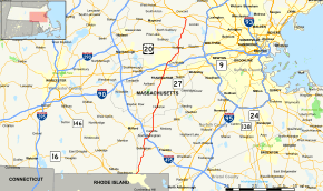
Massachusetts Route 126
| ||||
|---|---|---|---|---|
|
Map of eastern Massachusetts with Route 126 highlighted in red | ||||
| Route information | ||||
| Length: | 33.5704 mi[1] (54.0263 km) | |||
| Major junctions | ||||
| South end: |
| |||
| ||||
| North end: |
| |||
| Location | ||||
| Counties: | Worcester, Norfolk, Middlesex | |||
| Highway system | ||||
| ||||

Route 126 is a north–south state highway in Massachusetts.
Route description
Route 126 begins at the Rhode Island state line, continuing into Woonsocket as Rhode Island Route 126. After a short stretch in the town of Blackstone and Worcester County, Route 126 enters the town of Bellingham and Norfolk County, heading north. In Bellingham, Route 126 has a short concurrency with Route 140 at the center of town. In the north of the town, the route turns east on Hartford Avenue, crossing I-495 at Exit 18. Shortly after entering the town of Medway, the route turns north again, crossing Route 109 shortly after that. Route 126 then enters Holliston, in Middlesex County.
In Holliston, Route 126 shares a 2.3 miles (3.7 km) long concurrency with Route 16 through the center of town. After splitting from Route 16, Route 126 heads north into Ashland, passing through the eastern side of town before entering Framingham. The route passes Waushakam Pond before crossing Route 135 near the center of town, next to the Framingham MBTA station. The road bears to the right, passing Gleason Pond before crossing over Route 9 with exit ramps between the two. At this point, Route 30 eastbound joins Route 126 for a short stretch before meeting Route 30 westbound. Route 126 continues northward, crossing the Massachusetts Turnpike (I-90) without junction. (The nearest exit along the Pike is on Route 30 to the east.)
As it passes Lake Cochituate, Route 126 enters the town of Wayland. The route then joins Route 27 for a mile, crossing U.S. Route 20 together just before the two routes split. Route 126 then enters the town of Lincoln. After crossing Route 117, the route continues north, crossing the Fitchburg Line before entering Concord. As the route rounds the banks of Walden Pond through the State Reservation, it finally ends at Routes 2 and 2A next to Concord-Carlisle Regional High School.
Major intersections
| County | Location | mi | km | Destinations | Notes |
|---|---|---|---|---|---|
| Worcester | Blackstone | 0.00 | 0.00 | Continuation into Rhode Island | |
| Norfolk | Bellingham | 5.4 | 8.7 | Short, 90-yard concurrency with Route 140. | |
| 7.664 | 12.334 | I-495 Exit 18. | |||
| Medway | 10.3 | 16.6 | |||
| Middlesex | Holliston | 12.9 | 20.8 | Western terminus of concurrency with Route 16 | |
| 15.2 | 24.5 | Eastern terminus of concurrency with Route 16 | |||
| Framingham | 20.0 | 32.2 | Crossing point for the Boston Marathon. | ||
| 21.6 | 34.8 | Route 30 Eastbound ends its concurrency Route 9 and begins one with Route 126. | |||
| 21.8 | 35.1 | Western terminus of concurrency between Route 30 Eastbound and Route 126. To | |||
| 22.9 | 36.9 | No direct access between I-90 and Route 126. (Access is available via Cochituate Road.) | |||
| Wayland | 26.3 | 42.3 | Southern terminus of concurrency with Route 27. | ||
| 27.3 | 43.9 | ||||
| 27.4 | 44.1 | Northern end of concurrency with Route 27. | |||
| Lincoln | 31.3 | 50.4 | |||
| Concord | 33.57 | 54.03 | Northern end of Route 126; Walden Street continues north to | ||
1.000 mi = 1.609 km; 1.000 km = 0.621 mi
| |||||