Mariba, Kentucky
| Mariba | |
|---|---|
| Unincorporated community | |
 Mariba  Mariba Location within the state of Kentucky | |
| Coordinates: 37°54′58″N 83°34′43″W / 37.91611°N 83.57861°WCoordinates: 37°54′58″N 83°34′43″W / 37.91611°N 83.57861°W | |
| Country | United States |
| State | Kentucky |
| County | Menifee |
| Elevation | 1,175 ft (358 m) |
| Time zone | Eastern (EST) (UTC-5) |
| • Summer (DST) | EDT (UTC-4) |
| GNIS feature ID | 513788 |
Mariba is an unincorporated community in Menifee County, Kentucky, United States. It lies along U.S. Route 460 and Kentucky Route 77, southeast of the city of Frenchburg, the county seat of Menifee County.[1] Its elevation is 1,175 feet (358 m).[2] The community is part of the Mount Sterling Micropolitan Statistical Area.
The name "Mariba" is taken from Mariba Osborne Taylor.[3]
References
- ↑ Rand McNally. The Road Atlas '06. Chicago: Rand McNally, 2006, p. 43.
- ↑ U.S. Geological Survey Geographic Names Information System: Mariba, Kentucky, Geographic Names Information System, 1979-09-20. Accessed 2008-01-03.
- ↑ Rennick, Robert (1988). Kentucky Place Names. Lexington: University Press of Kentucky. p. 188. ISBN 0-8131-0179-4.
External links
Municipalities and communities of Menifee County, Kentucky, United States | ||
|---|---|---|
| City | 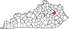 | |
| Unincorporated communities | ||
This article is issued from Wikipedia - version of the 7/27/2016. The text is available under the Creative Commons Attribution/Share Alike but additional terms may apply for the media files.