Denniston, Kentucky
| Denniston | |
|---|---|
| Unincorporated community | |
 Denniston  Denniston Location within the state of Kentucky | |
| Coordinates: 37°54′57″N 83°32′17″W / 37.91583°N 83.53806°WCoordinates: 37°54′57″N 83°32′17″W / 37.91583°N 83.53806°W | |
| Country | United States |
| State | Kentucky |
| County | Menifee |
| Elevation | 1,106 ft (337 m) |
| Time zone | Eastern (EST) (UTC-5) |
| • Summer (DST) | EDT (UTC-4) |
| ZIP codes | 40316 |
| GNIS feature ID | 511788 |
Denniston is an unincorporated community in Menifee County, Kentucky, United States. It lies along U.S. Route 460 and Kentucky Route 746, southeast of the city of Frenchburg, the county seat of Menifee County.[1] Its elevation is 1,106 feet (337 m).[2] Although it is unincorporated, it has a post office, with the ZIP code of 40316.[3]
Denniston is part of the Mount Sterling Micropolitan Statistical Area.
The community was named for its first postmaster, Joseph C. Denniston.[4]
References
- ↑ Rand McNally. The Road Atlas '06. Chicago: Rand McNally, 2006, p. 43.
- ↑ U.S. Geological Survey Geographic Names Information System: Denniston, Kentucky, Geographic Names Information System, 1979-09-20. Accessed 2008-01-03.
- ↑ Zip Code Lookup
- ↑ Rennick, Robert M. (1987). Kentucky Place Names. University Press of Kentucky. p. 81. Retrieved 2013-04-28.
Municipalities and communities of Menifee County, Kentucky, United States | ||
|---|---|---|
| City | 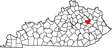 | |
| Unincorporated communities | ||
This article is issued from Wikipedia - version of the 10/10/2016. The text is available under the Creative Commons Attribution/Share Alike but additional terms may apply for the media files.