Margosatubig, Zamboanga del Sur
| Margosatubig | |
|---|---|
| Municipality | |
 | |
 Map of Zamboanga del Sur with Margosatubig highlighted | |
.svg.png) Margosatubig Location within the Philippines | |
| Coordinates: 07°35′N 123°10′E / 7.583°N 123.167°ECoordinates: 07°35′N 123°10′E / 7.583°N 123.167°E | |
| Country | Philippines |
| Region | Zamboanga Peninsula (Region IX) |
| Province | Zamboanga del Sur |
| District | 2nd district of Zamboanga del Sur |
| Founded | 1936 |
| Barangays | 17 |
| Government[1] | |
| • Mayor | Roy E. Encallado |
| Area[2] | |
| • Total | 111.69 km2 (43.12 sq mi) |
| Population (2015 census)[3] | |
| • Total | 37,873 |
| • Density | 340/km2 (880/sq mi) |
| Time zone | PST (UTC+8) |
| ZIP code | 7035 |
| Dialing code | +63 (0)62 |
| Income class | 3rd class |
Margosatubig is a third class municipality in the province of Zamboanga del Sur, Philippines. According to the 2010 census, it has a population of 37,873±0 people.[3]
History
The Subanens were believed to be the first people to have settled in this land, right near the swift flowing river that now traverse the Margosatubig Pilot School and Guiwan district. “Malagus Tubig” was the original name of the town, which was taken after the swift river current that kept changing its course towards the mouth of the Dumanquilas Bay. In the 15th century, the Spaniards arrived and found that its bay is a natural refuge from bad weather for their ships. Soon it became their choice settlement changing Malagus Tubig to its present name Margosatubig. They built a huge stone fort on top of a hill that served as their bastion against Moro pirates who used to raid the settlements along the Dumanquillas Bay and its vicinity. The fort was known as Cotta Heights. In 1963, it was demolished and is now the site of Pax High School. The Spaniards reigned for years and left as their heritage most evidently, the Chavacano dialect. Suffice it to say that more than a hundred years ago, Margosatubig already existed as a settlement of migrants and natives in the 19th century.
From 1917 to 1936, Margosatubig stayed as a municipal district of the city of Zamboanga. During the Commonwealth Government and by virtue Executive Order No. 17 dated December 23, 1936 signed by President Manuel L. Quezon, Margosatubig finally became a regular and distinct municipality with eight original barrios. It can be said that Margosatubig is the oldest town in Zamboanga del Sur; older even than the undivided Province of Zamboanga.
In 1950, the barrios of Punta Flecha, Pitogo, Qugbay, Balong-balong, Libertad and Dumanguilas were transferred to the newly created town of Dimataling[4]
In 1951, the barrios of Malangas, La Dicha, Diplo, Gusem, Buug, Matinaw, Gaulan, Tinungtungan, Manangon, Lindang, Luop, Silupa, Minsulao, Paruk, Lubing, Balabao, Mali, Baluran, Sampuli and Bacao, all from Margosatubig were separated to form the town of Malangas.[5]
Margosatubig, in spite of being a pioneer town, still remained isolated and reachable only by sea craft. In 1976, it was finally opened to the rest of Zamboanga del Sur by an asphalt road connecting it to Pagadian. This was facilitated by the Zamboanga del Sur Development Project undertaken by the Philippine-Australian Development Assistance Programme (PADAP), and its Electrification by ZAMSURECO-1 followed in 1979.
Barangays
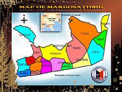
Margosatubig is politically subdivided into 17 barangays.[2]
- Balintawak
- Bularong
- Digon
- Guinimanan
- Igat Island
- Josefina
- Kalian
- San Roque (Kolot)
- Limamawan
- Limbatong
- Lumbog
- Magahis
- Poblacion
- Sagua
- Talanusa
- Tiguian
- Tulapok
Demographics
| Population census of Margosatubig | ||
|---|---|---|
| Year | Pop. | ±% p.a. |
| 1990 | 28,747 | — |
| 1995 | 29,597 | +0.55% |
| 2000 | 34,461 | +3.32% |
| 2007 | 34,939 | +0.19% |
| 2010 | 35,596 | +0.68% |
| Source: National Statistics Office[3] | ||
Media
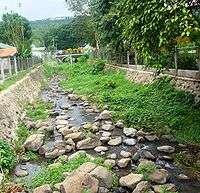
- Tourist Spots at Margosatubig
 Dumanquillas Bay at Margos
 Margos crossing
 Former DAO Beach Resort, now owned and developed as Rodolfo's Beach Resort
 Floating Cottages found at Rodolfo's Beach Resort
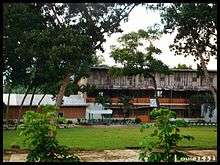
 Park fronting the municipal Hall
 JJB Resort of Margos
 View of JJB Resort from the Cottage
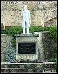 Jose Rizal Statue fronting Municipal Hall
Educational Institutions
Radio
- FM
- 91.3 DXRH Radyo Natin FM (Manila Broadcasting Company)
- 94.9 DXEW YES! FM (Manila Broadcasting Company)
- 97.7 DXTJ Radyo Kapital (MIT-RTVN)
- 100.9 DXAW Magik FM (Century Broadcasting Network)
References
- ↑ "Official City/Municipal 2013 Election Results". Intramuros, Manila, Philippines: Commission on Elections (COMELEC). 12 May 2014. Retrieved 22 July 2014.
- 1 2 "Province: ZAMBOANGA DEL SUR". PSGC Interactive. Makati City, Philippines: National Statistical Coordination Board. Retrieved 16 July 2014.
- 1 2 3 "Total Population by Province, City, Municipality and Barangay: as of May 1, 2010" (PDF). 2010 Census of Population and Housing. National Statistics Office. Retrieved 16 July 2014.
- ↑ "An act to create the municipality of Dimataling in the province of Zamboanga". LawPH.com. Retrieved 2011-04-09.
- ↑ "An Act Creating the Municipality of Malangas in the Province of Zamboanga". LawPH.com. Retrieved 2011-04-09.
External links
| Wikimedia Commons has media related to Margosatubig, Zamboanga del Sur. |
 |
Igat Bay / Lapuyan | San Miguel | | |
| Malangas, Zamboanga Sibugay / Dumanquilas Bay | |
Dimataling | ||
| ||||
| | ||||
| Vincenzo A. Sagun |
Pagadian (capital) | |
| Municipalities | |
| Component city | |
| Highly urbanized city |
|