Manada Gap, Pennsylvania
| Manada Gap, Pennsylvania | |
|---|---|
| Unincorporated community | |
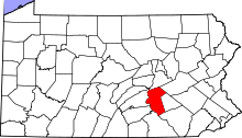
 Manada Gap Location within the state of Pennsylvania | |
| Coordinates: 40°23′49″N 76°42′36″W / 40.39694°N 76.71000°WCoordinates: 40°23′49″N 76°42′36″W / 40.39694°N 76.71000°W | |
| Country | United States |
| State | Pennsylvania |
| County | Dauphin |
| Township | East Hanover |
| Time zone | Eastern (EST) (UTC-5) |
| • Summer (DST) | EDT (UTC-4) |
| Official name | Fort Manada |
| Designated | May 12, 1982[1] |
Manada Gap is an unincorporated community in Dauphin County, Pennsylvania, United States, in the Harrisburg-Carlisle area, near Fort Indiantown Gap.
Fort Manada
Distant about twelve miles from Fort Hunter is the passage through the Blue Range called Manada Gap, the next station in the chain occupied by the government. As in the case of Fort Hunter, the settlers about Manada Gap had already commenced a place of defense in the latter part of the fall of 1755. In February 1756, Captain Frederick Smith, with his company of provincials, either completed the fort already commenced or erected a new one. This was called Manada Fort.
It was the ordinary block-house surrounded by a stockade. It stood on what is now the property of William Rhoads, east of the Manada Creek, about midway between it and the road to Jonestown, Pennsylvania and three-quarters of a mile south of the mill in Manada Gap. On the historical map it is located on the wrong side of the stream and rather too close to the mountain. Being of minor importance,or at least so considered, it was used only a couple of years. The exact location of this fort has never before been given.[2]
Notes
- ↑ "PHMC Historical Markers Search" (Searchable database). Pennsylvania Historical and Museum Commission. Commonwealth of Pennsylvania. Retrieved 2014-01-25.
- ↑ The American Historical Register -.