Los Santos District
| Los Santos District | |
|---|---|
| District | |
|
La Villa de los Santos | |
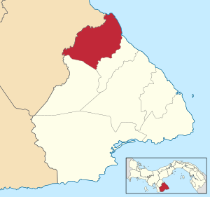 | |
 Los Santos District Location of the district capital in Panama | |
| Coordinates: 7°50′N 80°20′W / 7.833°N 80.333°W | |
| Country |
|
| Province | Los Santos Province |
| Capital | Las Tablas |
| Area | |
| • Total | 166 sq mi (429 km2) |
| Population (2000) | |
| • Total | 23,828 |
| Time zone | ETZ (UTC-5) |
Los Santos District is a district (distrito) of Los Santos Province in Panama. The population according to the 2000 census was 23,828.[1]The district covers a total area of 429 km². The capital lies at the city of La Villa de los Santos.[1]
Administrative divisions
The district is divided administratively into the following corregimientos:
La Villa de los Santos (capital), El Guásimo, La Colorada, La Espigadilla, Las Cruces, Las Guabas, Los Angeles, Los Olivos, Llano Largo, Sabanagrande, Santa Ana, Tres Quebrada, Villa Lourdes and Agua Buena.
References
- 1 2 "Districts of Panama". Statoids. Retrieved April 12, 2009.
Capital: Las Tablas | ||
| Guararé District |  | |
| Las Tablas District | ||
| Los Santos District | ||
| Macaracas District | ||
| Pedasí District | ||
| Pocrí District | ||
| Tonosí District | ||
| Bocas del Toro Province | |
|---|---|
| Chiriquí Province | |
| Coclé Province | |
| Colón Province | |
| Darién Province | |
| Herrera Province | |
| Los Santos Province | |
| Panamá Province | |
| Veraguas Province | |
| West Panamá Province | |
Coordinates: 7°50′N 80°20′W / 7.833°N 80.333°W
This article is issued from Wikipedia - version of the 10/5/2015. The text is available under the Creative Commons Attribution/Share Alike but additional terms may apply for the media files.