Las Tablas District
| Las Tablas District | |
|---|---|
| District | |
 | |
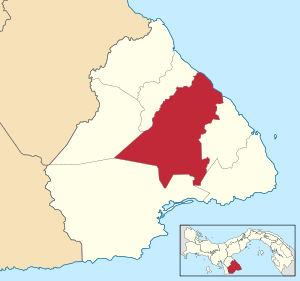 | |
 Las Tablas District Location of the district capital in Panama | |
| Coordinates: 7°46′N 80°17′W / 7.767°N 80.283°W | |
| Country |
|
| Province | Los Santos Province |
| Capital | Las Tablas |
| Area | |
| • Total | 269 sq mi (698 km2) |
| Population (2000) | |
| • Total | 24,298 |
| Time zone | ETZ (UTC-5) |
Las Tablas District is a district (distrito) of Los Santos Province in Panama. The population according to the 2000 census was 24,298.[1] The district covers a total area of 698 km². The capital lies at the city of Las Tablas.[1]
Administrative divisions
The district is divided administratively into the following corregimientos:
Las Tablas (capital), Bajo Corral, Bayano, El Carate, El Cocal, El Manantial, El Muñoz, El Pedregoso, La Laja, La Miel, La Palma, La Tiza, Las Palmitas, Las Tablas Abajo, Nuario, Palmira, Peña Blanca, Río Hondo, San José, San Miguel, Santo Domingo, El Sesteadero, Valle Rico and Vallerriquito.
References
- 1 2 "Districts of Panama". Statoids. Retrieved April 12, 2009.
Capital: Las Tablas | ||
| Guararé District |  | |
| Las Tablas District | ||
| Los Santos District | ||
| Macaracas District | ||
| Pedasí District | ||
| Pocrí District | ||
| Tonosí District | ||
| Bocas del Toro Province | |
|---|---|
| Chiriquí Province | |
| Coclé Province | |
| Colón Province | |
| Darién Province | |
| Herrera Province | |
| Los Santos Province | |
| Panamá Province | |
| Veraguas Province | |
| West Panamá Province | |
Coordinates: 7°46′N 80°17′W / 7.767°N 80.283°W
This article is issued from Wikipedia - version of the 10/5/2015. The text is available under the Creative Commons Attribution/Share Alike but additional terms may apply for the media files.