Little Rock Creek (Los Angeles County, California)
| Little Rock Creek | |
| stream | |
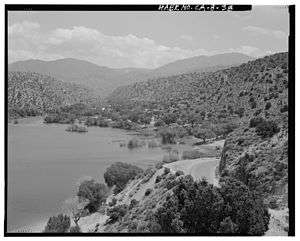 View to south over reservoir into Little Rock Creek Watershed | |
| Country | United States |
|---|---|
| State | California |
| Region | Los Angeles County |
| Tributaries | |
| - left | South Fork Little Rock Creek, Santiago Canyon Creek |
| Cities | Littlerock, Palmdale |
| Source | Mount Williamson |
| - location | San Gabriel Mountains |
| - elevation | 8,000 ft (2,438 m) [1] |
| - coordinates | 34°22′16″N 117°51′35″W / 34.37111°N 117.85972°W [2] |
| Mouth | Little Rock Reservoir |
| - elevation | 3,268 ft (996 m) [2] |
| - coordinates | 34°28′09″N 118°01′11″W / 34.46917°N 118.01972°WCoordinates: 34°28′09″N 118°01′11″W / 34.46917°N 118.01972°W [2] |
Little Rock Creek is a 16.7-mile (26.9 km) northwestward-flowing stream in the San Gabriel Mountains and Mojave Desert, within northern Los Angeles County, California.
Its headwaters are in the Angeles National Forest, just west of Mount Williamson peak.[2] Downstream the creek enters Little Rock Reservoir, impounded by Little Rock Dam. After released there it flows through Little Rock Wash into the Antelope Valley of the western Mojave Desert.[2]
History
According to the toponomastic scholar, Erwin Gudde, "little" often refers to a place name when it is near to a larger geographic feature,[3] in this case Little Rock Creek being close to Big Rock Creek[4]
The fifth Pacific Railroad Survey led by Lt. Robert Stockton Williamson and Colonel John Parke visited Little Rock Creek in 1853, as they surveyed the north slope of the San Gabriel Mountains.[5] The first non-native settlement in the area was Santiago García, who was born circa 1833. He built an adobe on the north side of Little Rock Creek approximately 0.5 miles (0.80 km) to the east of where the creek turned from north to east near Totem Pole Ranch. At this wet spot, where the San Andreas fault system forced water to the surface, the Garcia cienaga (canyon) was located. Santiago Garcia was killed in 1873 by a grizzly bear in what was later named Santiago Canyon.[5]
Watershed and Course
Little Rock Creek's originates just west of the summit of 8,199 feet (2,499 m) Mount Williamson and flows down the north slope of the San Gabriel Mountains. Its main tributaries are South Fork Little Rock Creek[6] and then Santiago Canyon Creek[7] just before reaching Little Rock Reservoir. At Little Rock Dam it becomes Little Rock Wash[8] which terminates in the Antelope Valley. Little Rock Creek is part of the Antelope Valley Watershed, which is a closed endorheic basin with no outlet. It is part of the South Lahontan Hydrologic Region.[9]
Ecology
Lower Little Rock Creek is home to the endangered arroyo toad (Anaxyrus californicus), a factor leading to the closure of Little Rock Road and the forested areas upstream from the reservoir.[10] The upper segment of the creek is located in the newly designated Pleasant View Ridge Wilderness area and supports an important population of endangered mountain yellow-legged frog (Rana muscosa).[11]
The Little Rock Creek watershed was protected by the October, 2014 designation of the San Gabriel Mountains National Monument.
See also
References
- ↑ U.S. Geological Survey. National Hydrography Dataset high-resolution flowline data. The National Map, accessed November 30, 2014
- 1 2 3 4 5 "Little Rock Creek". Geographic Names Information System. United States Geological Survey.
- ↑ Erwin G. Gudde (1960). California Place Names: The Origin and Etymology of Current Geographical Names. University of California Press. p. C-179. Retrieved 2014-11-30.
- ↑ "Big Rock Creek". Geographic Names Information System. United States Geological Survey.
- 1 2 David Earle (2003-01-08). "Mining and Ranching in Soledad Canyon and Antelope Valley". Santa Clarita Valley Historical Society. Retrieved 2014-11-30.
- ↑ "South Fork Little Rock Creek". Geographic Names Information System. United States Geological Survey.
- ↑ "Santiago Canyon". Geographic Names Information System. United States Geological Survey.
- ↑ "Little Rock Wash". Geographic Names Information System. United States Geological Survey.
- ↑ South Lahontan Hydrologic Region: California Water Plan (PDF) (Report). California Department of Water Resources. 2013. Retrieved 2014-11-30.
- ↑ "Little Rock Recreation Area Now Under Permit and Managed by Concessionaire". USDA Forest Service. Retrieved 2014-11-30.
- ↑ "San Gabriel Wild & Scenic Campaign". Friends of the River. Retrieved 2014-11-30.
External links
- U.S. Geological Survey Geographic Names Information System: Guadalupe Creek - Geographic Names Information System
- Friends of the River