Little Ponton
| Little Ponton | |
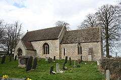 St Guthlac's Church, Little Ponton |
|
 Little Ponton |
|
| Population | 135 |
|---|---|
| OS grid reference | SK925324 |
| – London | 95 mi (153 km) S |
| Civil parish | Little Ponton and Stroxton |
| District | South Kesteven |
| Shire county | Lincolnshire |
| Region | East Midlands |
| Country | England |
| Sovereign state | United Kingdom |
| Post town | GRANTHAM |
| Postcode district | NG33 |
| Dialling code | 01476 |
| Police | Lincolnshire |
| Fire | Lincolnshire |
| Ambulance | East Midlands |
| EU Parliament | East Midlands |
| UK Parliament | Grantham and Stamford |
|
|
Coordinates: 52°52′53″N 0°37′32″W / 52.88125°N 0.62553°W
Little Ponton is a village in the South Kesteven district of Lincolnshire, England. It lies 2 miles (3 km) south of Grantham and about 60 metres (200 ft) above sea level. The population is included in the figure for the civil parish of Little Ponton and Stroxton.
History
Part of the Roman road of Ermine Street (known locally as the High Dyke) passes through the parish.[1]
The village belonged to the historical wapentake of Winnibriggs and Threo.[2]
The village was described in John Marius Wilson's Imperial Gazetteer of England and Wales (1870–72) as "a parish in Grantham district, Lincoln; on Ermine-street, the river Witham, and the Great Northern railway, 1½ mile N of Great Ponton r.station, and 2 S of Grantham. It has a post-office under Grantham. Acres, 1, 490. Real property, £2, 590. Pop., 208. Houses, 43. The property belongs to Turnor, Esq. P. Hall was occupied formerly by the Duke of Cleveland, and is occupied now by Broke Turnor, Esq. Many Roman relics have been found. The living is a rectory in the diocese of Lincoln. Value, £400.* Patron,Turnor, Esq. The church is old but good, and has a low tower."[3]
Little Ponton Hall is a Grade II listed building. It dates from 1725 with later additions.[4]
Geography
Little Ponton is part of the civil parish of Little Ponton and Stroxton.[5] It is situated just off the B1174 (the former A1).
Little Ponton ecclesiastical parish extends along a footpath across the west side of the A1 as far north as Warren Plantation. The boundary crosses the A1 just before the A1 reaches the summit of the hill (as viewed northwards). It follows Tollemache Road South on the industrial estate then follows the road down to the Saltersford sewage works, passing to the north of Daily Mail Farm, where it meets the parish of Londonthorpe and Harrowby Without. Most of the sewage works is in the parish. The boundary crosses the East Coast Main Line and due east it meets Whalebone Lane, crossing it on the north edge of Whalebone Spinney. Eastward it crosses the High Dike or Ermine Street (B6403), where it meets the parish of Old Somerby. To the south the parish includes Woodnook and Woodnook Farm. The boundary follows a footpath south-west through Griff's Plantation. At a point 1 mile (1.6 km) east of the B6403, the boundary meets Boothby Pagnell. At a point south of Poplar Farm and north of Boothby Great Wood, the boundary meets the parish of Great Ponton. The boundary crosses the B6403 next to Ponton Park Wood (east of the B6403). It follows due west to cross the East Coast Main Line just north of Great Ponton. It crosses the River Witham and continues due west, then crosses the A1 and reaches Gibbet Hill. At Stroxton Spinney, the boundary follows northwards, crossing the Stroxton–Little Ponton road and follows a footpath.[1]
Woodnook Valley

Woodnook Valley has been a Site of Special Scientific Interest since March 1986.[6] It is described by Natural England as "a very good representative example of calcareous [limy] grassland developed on soils derived from Eastern Jurassic Limestone." It consists of two grazed fields, one facing north and the other south. The grasses are generally short and typical limestone herbs can flourish. It supports several species of orchid, including early-purple orchid Orchis mascula, bee orchid Ophrys apifera, and man orchid Aceras anthropophorum (now termed Orchis anthropophora), which at this site is near its northern limits of distribution in Britain.[7]
Community
With Stroxton, the civil parish had a population in 2001 of 135. There are no village amenities.
The ecclesiastical parish is part of the Colsterworth Group of the Deanery of Beltisloe. The 2013 incumbent is Reverend Eric John Lomax.[8][9] Little Ponton parish church is dedicated to Saint Guthlac. It dates from the Norman period, but is largely of Decorated style. The west front was rebuilt in 1657. The chancel arch may be Saxon.[10]
The film and stage actor and soldier Richard Todd (1919–2009) is buried in the churchyard, between two of his sons, who predeceased him.
References
- 1 2 Grantham: Bottesford & Colsterworth (Map) (A1 ed.). 1:25 000. OS Explorer. Ordnance survey of Great Britain. 3 January 2006. § 247. ISBN 9780319238332.
- ↑ Vision of Britain site: Retrieved 16 March 2012.
- ↑ Quoted in A Vision of Britain through Time Retrieved 6 October 2016.
- ↑ Historic England Retrieved 6 October 2016.
- ↑ "Civil parish details". Retrieved 10 March 2013.
- ↑ "SSSI name: Woodnook Valley". SSSI information. Natural England. Retrieved 12 September 2013.
- ↑ Woodnook Valley SSSI Retrieved 27 November 2016.
- ↑ "The Colsterworth Group of Churches". Colsterworth5.co.uk. Retrieved 17 January 2014.
- ↑ "Little Ponton P C C". Diocese of Lincoln. Retrieved 16 March 2013.
- ↑ Historic England. ""St Guthlacs church" (325757)". PastScape. Retrieved 17 March 2013.
External links
 Media related to Little Ponton at Wikimedia Commons
- Little Ponton: St Guthlac's church
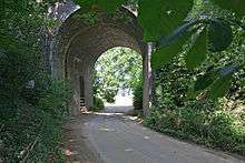
- Woodnook Valley High Dyke to Little Ponton
- Woodnook Valley
England Portal | |
| Unitary authorities | |
| Boroughs or districts | |
| Major settlements |
|
| Topics | |