Bourne, Lincolnshire
| Bourne | |
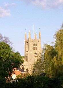
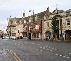 Bourne town centre |
|
 Bourne |
|
| Population | 13,961 [1] |
|---|---|
| OS grid reference | TF094202 |
| – London | 90 mi (140 km) S |
| Civil parish | Bourne |
| District | South Kesteven |
| Shire county | Lincolnshire |
| Region | East Midlands |
| Country | England |
| Sovereign state | United Kingdom |
| Post town | BOURNE |
| Postcode district | PE10 |
| Dialling code | 01778 |
| Police | Lincolnshire |
| Fire | Lincolnshire |
| Ambulance | East Midlands |
| EU Parliament | East Midlands |
| UK Parliament | Grantham and Stamford |
|
|
Coordinates: 52°46′06″N 0°22′39″W / 52.7684°N 0.3775°W
Bourne is a market town and civil parish in the South Kesteven district of Lincolnshire, England. Bourne is situated on the eastern slopes of the Kesteven Uplands and the western edge of the Lincolnshire Fens.[2] The population taken at the 2001 census was 13,961 increasing to 14,456 at the 2011 census.[3]
The town

The town is located on a Roman road now known as King Street and was built around the natural springs, hence the name 'Bourne' (or 'Bourn', as the town was originally known) which derives from the Anglo-Saxon meaning “water” or “stream”.[2][4] It lies on the intersection of the A15 and the A151 roads. The civil parish includes the main township plus the hamlets of Cawthorpe, Dyke and Twenty.[5] In former years Austerby was regarded as a separate settlement, with its own shops and street plan, but is now an area of Bourne known as The Austerby (52°45′47″N 0°22′12″W / 52.763°N 0.370°W).[6]

The ecclesiastical parish of Bourne is part of the Beltisloe Deanery of the Diocese of Lincoln and is based at the Abbey Church of St Peter and St Paul, in Church Walk. The incumbent is Revd Chris Atkinson.[7] Other religious denominations include Methodist, Baptist, United Reformed and Roman Catholic churches.
The town's economy was based on rural industries until the railway opened up a market for bottled mineral water. Although it is still focused on agriculture and food preparation for supermarkets there are also important light engineering and tourism activities. The district has a fast-growing housing market with considerable new building taking place in Bourne in the 2000s. The population was 12,000 in the 2001 Census data. There are approximately 5,424 households in Bourne as of 2007.
Agriculture

Sugar beet was first grown as an English crop in the fenland east of Bourne by British Sugar Ltd. It had been developed in Germany and France in the early 19th century. Although Britain's demand for sugar was mostly fulfilled by European beet imports until shortly after 1900, the successful sugar beet production in areas such as that around Twenty, fulfilled the nation's sugar requirements during the 20th century's two world wars.
Much of Bourne's 19th century affluence came from the corn trade boom following the mechanisation of fen drainage, and the production of wheat is still important. In the 21st century hydroponic food production plants have been built on the edge of the fen.
Manufacturing

Although the Autocast foundry has closed because of the shrinking British car industry, there are a number of small machine shops and fabricators in the south and east of the town. These include Pilbeam Racing in Graham Hill Way and Trackline International, manufacturers of 'crawler undercarriage systems'. Bourne has two printing companies and manufacturers of double glazing and fibreglass mouldings.
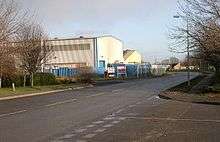
Warehousing and distribution
In the same area are distribution warehouses for a large brewer and general transport and storage companies, and a game merchant operates from one of the smaller factory estates.
Retail
As well as town centre shops, there are garden centres in Cherry Holt Road, furniture and decorating shopping in Manning Road, and specialist suppliers of kitchen, decorative, catering and light engineering supplies.
Government
Lincolnshire County Council
Bourne has two County Council wards:
Bourne Abbey:
- Mark Horn (Conservative). (Economic Wellbeing Scrutiny Panel): (Economic Development Policy Development Group).
- Councillor Horn resigned the Conservative Party whip at Lincoln over a disagreement with his colleagues on 25 June 2008.[8] Following a further dispute involving a possible reference under the Standards Code, Councillor Horn resigned from Lincolnshire County Council on 1 August 2008,[9] precipitating a by-election. The by-election between seven candidates took place on 2 October 2008. Nick Boles was elected as his replacement.[10]
Bourne Castle:
- Charlotte Farquharson (Conservative).
- Mrs Farquharson was elected after a by-election was held on 6 July 2006. The previous Councillor, Ian Croft (Conservative), appeared before the Adjudication Panel on 31 March 2006 and was found guilty on several charges of misconduct. He was an associate of Jim Speechley (a former leader of Lincolnshire County Council jailed for 18 months in 2004 after being found guilty of misconduct in public office[11] ) succeeding him as Leader of the Council. The Panel ordered that Mr Croft be suspended from office as a Councillor for fifteen months. He did not lodge an appeal, and resigned from the Council.
South Kesteven District Council
Bourne has three District Council wards, two having two councillors and the new ward, Austerby, having three councillors:
Bourne East:
- Cllr Bob Russell (Conservative).
- Cllr Judy Smith(Conservative).
Bourne West:
- Cllr David Mapp (Conservative ).
- Cllr Helen N J Powell ( Lincolnshire Independent ).
Bourne Austerby:
- Cllr Duncan Ashwell ( Conservative).
- Cllr Jane Kingman ( Conservative).
- Cllr Robert Reid ( Conservative).
Councillor Mrs Neal is the current Leader of South Kesteven District Council.
Bourne Town Council

Bourne Town Council has two wards which are identical to the South Kesteven District Council wards. Bourne East elects seven councillors to the town council and Bourne West eight.
From 1899 to 1974, Bourne had an urban district council in the former Parts of Kesteven. Under the Local Government Act 1972, Bourne UDC was dissolved into the newly formed South Kesteven district. Urban districts which disappeared in this way formed successor parishes and were given a dispensation to call their "parish" councils "town" councils, and the chairman is given the title town mayor. These town councils were allowed to adopt the coat of arms granted to the former UDC.
A Bourne Rural District also existed from 1894 to 1931, when it was abolished to form part of a larger South Kesteven Rural District. The parish of Bourne had formed part of Bourne RD from 1894 to 1899. South Kesteven R.D.C. had its own distinct coat of arms which disappeared along with that of Kesteven in 1974, and very few copies of either remain in existence.
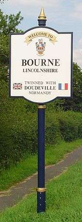
International links
Since October 1989, Bourne has been twinned with Doudeville, Seine Maritime, France.
Drainage
Parts of the west of Bourne are drained by one of two internal drainage boards, The Black Sluice IDB[12] and the Welland and Deepings IDB.[13]
Many houses in Bourne pay additional drainage rates to these authorities. Details of the designated flood risk areas can be found on a number of government web sites.[14][15]
Education
- Bourne Abbey Church of England Academy (Primary)
- Bourne Grammar School
- Bourne Academy formerly Robert Manning Technology College
- Bourne Westfield Primary Academy (Primary)
- Willoughby School (Special Needs)
Bourne Westfield Primary Academy

Built in the 1970s as part of the large expansion of housing to the west of the town, it has been twice enlarged to cope with increasing rolls. It has a roll of 629.[16] A November 2008 Ofsted inspection accorded the school a Grade 1 (outstanding).[17][18] Some former pupils of the school are now scattered worldwide, as far as Australia.[19] The school hosts its own pre-school facility, the Bluebird Pre-school Playgroup.[20] As of 2009, the school is an award holder in the schools section of the Clean Air Awards Scheme,[21] under the auspices of Lincolnshire County Council.[22] It was cited as a Flagship School for the Food for Life Partnership 2009 to 2010 achieving a bronze award,[23] partly with respect to its cookery club.[24] In 2010 it won Best School Garden in the East Midlands and a gold medal with Britain in Bloom. In 2009 the school had won a silver gilt medal in the same competition.[25] This was one of the first schools to be rated as a National Healthy School in the programme of the same name; it has been given the gold award for the quality and range of its sports provision under the Active Mark Scheme.[26] A pupil at the school received The Local's Rose Award in 2009 for caring for his mother during illness.[27] Local respect was demonstrated in 2008 for this school's educational and fundraising work, when its school fete received a flypast by a Spitfire and Dakota.[28] In 2007 and 2008, pupils filled 200 shoe boxes with gifts for needy children as part of the Operation Christmas Child appeal.[29][30] Pupils continue charity work outside the school; for example a pupil has contributed to the local newspaper's appeal to send gift boxes to military personnel serving abroad.[31]
In response to Bourne's tradition of agriculture and Lincolnshire's horticulture, and to its site and environment as detailed below, the school has its own gardening clubs and grows its own vegetables.[32] It has organised voluntary maintenance of public flower beds in Bourne by pupils since 2009.[33][34] An orchard has been donated to the school, and this has been maintained by the pupils with the aim of provision of some fruit to the school.[35] Besides the Food for Life Partnership award and the cookery club as mentioned above, the pupils cook pancakes for the Pancake Day celebrations.[36][37] The school has a choir which also sings in Bourne Methodist Church.[38] The choir has performed at local public events, such as the turning on of the Christmas lights in Bourne in 2007,[39] and charity events such as the Bourne Round Table dinner for pensioners in 2008.[40] As Lincolnshire champions and as representative of the East Midlands, the school's rugby team reached the finals of the Tag 2 Twickenham rugby tournament and competed at Rugby School in Warwickshire in 2009.[41] Cycling has been supported by the school, with a six-week Go-Ride cycling skills programme taking place in 2008.[42] Some pupils from the school take part in other sports such as motocross and skateboarding;[43] a pupil asked the council for a local skatepark in 2002, and the idea was being resurrected by the council as of 2010.[44][45] One pupil won three gold medals in the Cambridgeshire Gymnastics floor and vault competition in 2008.[46]
Westfield archaeological site
The school was built on the site of Westfield. Between the 9th and 20th centuries, Westfield was a set of three fields arranged as and used as an existing medieval agricultural three-field system,[47] which was a form of crop rotation in use from the Middle Ages. It is this site which accounts for the name of the school. The site is close to and associated with Car Dyke,[48][49] and this may imply a connection between the three-field system and the dyke, involving drainage, irrigation and transport of crops and materials.[50][51][52] The historical association between Westfield and Car Dyke for crop and materials transport is a strong probability because droving roads and the later turnpikes were less viable than waterways until the A151 road was built.[53] In the tradition of UK primary schools, the pupils are taught geography and history in the context of the school's site environment as well as contemporary and worldwide context. That is to say, the school's site and environment directly affects the education of the pupils.[16][35]
School buildings
The original modern building was created in 1973 by a team of architects in Lincolnshire Council's building department. It would have been a flat-roofed building.[54][55] Since then, there has been a series of extensions which are now fused to form a cohesive unit. The most recent two projects on the site were designed by Wilson and Heath of Stamford,[56] who built a covered courtyard and library at the school.[55] This architectural firm has worked on Fishmongers' Hall in London and the University of Exeter, and has won a civic award in Stamford.[57] Two more classrooms and a covered way are now being planned by the school, which is again using the same architects.[58]
Communications
Road
Bourne Market Place is at the crossroads of the A15 road and the B1193. Strictly speaking, it was a staggered pair of T-junctions where the A15 was met by the A151 from Spalding to the east and the B676 from the west (the article A151 road explains) before the B676 was redesignated as an extension of the A151 to Colsterworth. The A151 was diverted from the town centre via Cherry Holt Road and a newly opened relief road in 2005. When the rapid expansion of the town was first proposed in the early 1990s, development was scheduled to the north-east of the town, and part of this would have been a north/south bypass on the A15 under Section 106 of the Town and Country Planning Act 1990. However, the chosen site was shifted to the south-west of the town, and the proposed by-pass was lost. A large volume of traffic is generated within the town, with the result that the A15 between Bourne and Peterborough is one of the busiest roads in the county. To the west of the town, the A6121 branches from the A151 and takes traffic towards Stamford
When the relief road opened, the section of the A151 in the town centre was renumbered. However, ever since then some published road maps are incorrect. The A151 now follows Cherry Holt Road, it no longer continues to the town centre. The only reliable map is the Ordnance Survey: TF1020. The error seems also to affect satellite navigation systems, causing large lorries to attempt a tight corner in the town centre rather than keeping to the correct roads.
Bus
There is a bus station at the top of North Street.
The town's bus services are provided by Delaine, a family-owned and run company which has been operating in Bourne for many years.
There is a daily long-distance coach from Grimsby to London Victoria that stops at Bourne bus station around 11.00 am, the return journey arriving just after 5.30 pm.
History

The Ancient Woodland of Bourne Woods, although much reduced, is still extant and originally formed part of the ancient Forest of Kesteven and is now managed by the Forestry Commission.
The earliest documentary reference to Brunna, meaning stream, is from a document of 960, and the town appeared in the Domesday Book as Brune.[2]
Bourne Abbey, (charter 1138), formerly held and maintained land in Bourne and other parishes. In later times this was known as the manor of 'Bourne Abbots'. Whether the canons knew that name is less clear. The estate was given by the Abbey's founder, Baldwin fitz Gilbert de Clare, son of Gilbert fitz Richard, and later benefactors. The abbey was established under the Arrouaisian order. Its fundamental rule was that of Augustine and as time went on, it came to be regarded as Augustinian. The Ormulum, an important Middle English Biblical gloss, was probably written in the abbey in around 1175.
Bourne Castle was built on land that is now the Wellhead Gardens in South Street.[59][60][61]

Bourne was an important junction on the Victorian railway system, but all such connections were severed after the Second World War (see Rail heading). The business stimulus it brought caused major development of the town, and many of the buildings around the medieval street plan were rebuilt, or at least refaced. Improved communications allowed a bottled water industry to develop, and to provide coal deliveries for the town's gas works.
The then local authority, Bourne Urban District Council, was very active in the interests of the town, taking over the gas works and the local watercress beds at times of financial difficulty and running them as commercial activities. Large numbers of good quality council houses were built by them in the early 20th century.
Bourne sent many men to both of the 20th century's world wars, as did any other town in Britain, but was otherwise only lightly affected. During the Second World War a German bomber crashed onto the Butcher's Arms public house in Eastgate, after being shot down. Nine people were killed, including the bomber's crew. In a separate incident a number of bombs were dropped on the Hereward Camp approved school, a row of wooden huts adjacent to the woods that may have been mistaken for a military camp. Charles Richard Sharpe was injured in the second incident, but he was no stranger to fighting the Germans, having been awarded the Victoria Cross in the first conflict of the century.
Railways

The first local railway was the Earl of Ancaster's estate railway, which ran from the East Coast Main Line at Little Bytham, through the Grimsthorpe estate to Edenham.[62]
Later Bourne had a railway station which was on both the Great Northern line from Essendine[63] to Sleaford and the Midland and Great Northern Joint Railway connecting the Midlands[64] to East Anglia. Both these were closed to timetabled passenger service by the end of February 1959 and the lines were closed to occasional use by the Beeching Axe. With the exception of the Red Hall, the principal station buildings were demolished in 1964, the year after the Beeching Report. The main goods shed survived however, just into the new century and there remains an unusual survival: a goods store of wooden construction. The mechanism of the locomotive turntable is now in the Wansford depot of the Nene Valley Railway.
Shipping
The Bourne-Morton Canal or Bourne Old Eau connected the town to the sea in Roman times.
Until the mid-19th century, the present Bourne Eau was capable of carrying commercial boat traffic from the Wash coast and Spalding. This resulted from the investment following the Bourne Navigation Act of 1780. Passage became impossible once the junction of the Eau and the River Glen was converted from gates to a sluice in 1860.
Sport
Bourne Town Football Club, nicknamed "The Wakes", plays football in the United Counties Football League and the junior club runs teams for young people at all ages in local league competitions. Bourne Cricket Club is one of the strongest in the Lincolnshire ECB Premier League having won the competition three times since it started in 2000. The club often provides players for the Lincolnshire Minor Counties team. These teams play their home games at the Abbey Lawn, a recreation ground privately owned by the Bourne United Charities. Also at "The Lawn" are the tennis and bowls clubs, Bourne Rugby Club is based outside the town at Milking Nook Drove 52°46.2420′N 0°20.2560′W / 52.7707000°N 0.3376000°W, with senior teams and thriving Junior and Mini sections – over 100 players are to be seen training and playing on Sundays from 10.30 am. The hockey club is obliged to play elsewhere, as there is not a suitable all-weather playing surface in the town. Bourne also hosts a number of other sporting clubs, particularly in the field of martial arts, and efforts to build a skate park continue. The leisure centre is attached to Bourne Academy and caters for a number of indoor activities, including a swimming pool.
On 4 July 2012, UK javelin thrower Goldie Sayers carried the Olympic Torch through Bourne.
Motorsport

The racing car marques English Racing Automobiles (E.R.A.) and British Racing Motors (BRM) were both founded in Bourne by Raymond Mays, an international racing driver and designer. E.R.A. started in 1934 and BRM's first car was unveiled in 1949 at Folkingham Airfield.
The former ERA and BRM workshops on Spalding road are, as of 2013, used as an auction saleroom by Golding, Young and Mawer. They are adjacent to Eastgate House Mays' family home in the town's Eastgate.[65] The achievements of Raymond Mays are commemorated in a Memorial Room at the town's Heritage Centre (Baldock's Mill in South Street) where many of his trophies are displayed, having been donated by his PA Trissie Carlton and her daughter Anne Boggitt. The room contains photographs, memorabilia and silverware won by BRM cars and drivers. A collection of BRM cars paraded around the town in August 1999 and a memorial to Raymond Mays was unveiled in South Street in 2003.
In 1975 Mike Pilbeam, BRM's former Chief Designer, set up Pilbeam Racing Designs and achieved success in hillclimbing in the 1980s and early 1990s.
Landmarks
Bourne buildings

| Wikimedia Commons has media related to Red Hall, Bourne. |
There are currently 71 listed buildings in the parish of Bourne, the most important being "Bourne Abbey and Parish Church of St. Peter and St. Paul" (1138) which is the only one scheduled Grade I. The others are Grade II, the most colourful being the aptly named Red Hall (ca. 1620), finished in red brick with ashlar quoins, many gabled and featuring a fine Tuscan porch. From 1860 to 1959, it was the town's railway station booking office and waiting room. At two stages, in the 1890s and 1960s, it came close to demolition but the building is now well preserved by Bourne United Charities. The former station booking office serves as the BUC's office.
Baldock's Mill (1800), once a corn-grinding water mill, together with the miller's house, has been converted by Bourne Civic Society to serve as the town's Heritage Centre. It houses many interesting artefacts, most recently a water-wheel has been installed and a newly created replica of a Charles Frederick Worth dress is on display.
The Baptist Church building dates from 1835 but the church itself was established here in the 1640s. This building, the Methodist Church (1841) and the United Reformed Church (1846) are all still in active use.
Under threat
The Old Grammar School[66] was a red-brick building with a Collyweston roof, built in the 17th century and largely rebuilt in 1738. The school closed in 1904, and the building, which stands in the Abbey churchyard, has since been used for a variety of purposes. The roof was condemned as unsafe in April 2003 but was repaired, although the building is no longer in regular use.
At the cemetery owned and run by the town council is a chapel,[67] built in 1855. In recent years, the building has not been used as a chapel, and the fabric has deteriorated. This is attributed to a lack of maintenance by the council due to financial constraints, however, the shallowness of the foundations is said to be the principal cause.[68] The chapel now requires considerable expenditure if it is to survive, but on 23 January 2007 the town council took the decision to demolish it.[69] In 2007, Bourne historian Rex Needle applied for and obtained a Grade II listing from the Department for Culture, Media and Sport, which secures the building from demolition for the foreseeable future. In 2008, the effort is now under way to identify a source of funding (estimated around £400,000) to render the building fit for long-term community use.
In July 2008, the Ostler Memorial in the town's cemetery, an ornate Gothic water fountain originally erected in the market place in 1860 to the memory of local benefactor John Lely Ostler (1811–59) but neglected in recent years, was also given a Grade II status by DCMS bringing the total number of listed buildings in Bourne to 71.
Nearby landmarks


- Bourne Civic Society's heritage centre in Baldock's Mill, South Street
- Bourne Wood; 400 acres (2 km²) of woodland which has been a resource since primeval times. There is now a sculpture trail and the wood forms part of the 19-mile Bourne Cycle Trail.
- Grimsthorpe Castle. A landed estate, large country house and tourist attraction. The castle's web site.
- Bowthorpe Oak, A tree old at the time of the Domesday survey. On private land, an admission charge is levied.
Notable people
- Bourne is reputedly the birthplace of Hereward the Wake (in about 1035), although the 12th-century source of this information, De Gestis Herwardi Saxonis,[70] refers in this connection only to his father as being 'of Bourne' and to the father's house and retainers[71] there. Charles Kingsley used the De Gestis text for his lively 1866 novel which repeats the fundamental story with much descriptive embellishment.[72]
- Orm (or Ormin) the Preacher (flourished 1180) worked at Bourne Abbey during the 12th century, about a century earlier than Robert Mannyng (see below) but his presence here has only been revealed during recent research. His collection of homilies known as The Ormulum has been well known to linguists and language historians ever since the 17th century but its source has only recently been established as Bourne Abbey. Orm's language provides a glimpse of the English vernacular of the time and before it was strongly influenced by the French. It is assumed that the manuscript remained at Bourne Abbey until the Dissolution of the Monasteries between 1536 and 1540 and after various owners, it is now in the Bodleian Library at Oxford University, where it is kept in conditions in keeping with its age and fragility.
- Robert Mannyng (1264–1340) is perhaps the most notable of the town's past citizens. He is credited with putting the speech of the ordinary people of his time into recognisable form. He is better known as Robert de Brunne because of his longtime residence as a canon at Bourne Abbey. There he completed his life's work; he popularised religious and historical material in a Middle English dialect that was easily understood by the people of his time. His work Handlyng Synne is acknowledged to be of great value because it gives glimpses into the ways and thoughts of his contemporaries and even more, shows us the language then in common use.
- William Cecil (1520–1598) became the first Lord Burghley after serving Queen Elizabeth I for forty years, during which time he was the main architect of Britain's policies, with a reputation as for renaissance statecraft, diplomat, politician and administrator. He was born at a house in the centre of Bourne that is now the Burghley Arms and a plaque on the outside reminds us of this event.
- Job Hartop (1550–1595) was a farmer's boy working on the land near Bourne but hankered after a life of adventure and ran away to sea when he was twelve years old. After a short apprenticeship with a gunpowder manufacturer in London, he signed on with the English admiral Sir John Hawkins and sailed the Spanish Main in the company of the young Francis Drake. He was captured by the Spanish on his third voyage and spent ten years as a galley slave and thirteen years in a Spanish prison but escaped and returned to Bourne where he died aged 45.
- Robert Harrington (philanthropist) (1589–1654) made bequests which still benefit Bourne. Legend has it that he walked to London to seek his fortune and was most successful in his endeavours and he bequeathed shops and dwelling houses in the Leytonstone area "for the benefit of his own people", namely the citizens of Bourne. The charity established in his name is administered by Bourne United Charities and fittingly, Harrington Street was named in his memory.
- Dr William Dodd (1729–1777), was an Anglican clergyman, a man of letters and a forger. He was also the son of the Rev William Dodd who was Vicar of Bourne from 1727–56, graduating with distinction from Clare College, Cambridge, and then moved to London where his extravagant lifestyle soon landed him in debt and worried his friends who persuaded him to mend his ways and so he decided to take holy orders and was ordained in 1751. He became a popular and fashionable preacher but was always short of money and in an attempt to rectify his depleted finances, forged a bond in the sum of £4,200. He was found out, prosecuted and sentenced to death and publicly hanged at Tyburn on 27 June 1777.
- Charles Frederick Worth (1825–1895), the son of a solicitor, lived at Wake House in North Street which is now a community centre. He moved to Paris and became a world-renowned designer of women's fashion and the founder of haute couture. The French government awarded him the Légion d'honneur and the President of the French Republic was among the 2,000 attendees at his funeral.
- Sir George White was a cobbler's son who was born above his father's shop in West Street, Bourne, in 1840. He left home at 16 to work at a boot and shoe factory in Norwich but soon made his mark in business, the Baptist movement and in public life, becoming an alderman and Sheriff of Norwich and later MP for North West Norfolk, a seat which he held for twelve years until he died in 1912, aged 72. He was knighted for his public service in 1907.
- Robert A Gardner (1850–1926) was a bank manager in Bourne and also a talented artist whose work was exhibited in the Royal Academy. He was a magistrate and chairman of the Bourne bench. His paintings are mostly in private ownership although some are displayed in the Red Hall.
- Frederic Manning (1882–1935) wrote what is considered to be one of the finest novels dealing with World War I of 1914–18 and much of this work was completed while staying at the Bull Hotel in Bourne, now the Burghley Arms. Manning was an Australian who chose to live here after a spell at Edenham where he stayed with the vicar, the Rev Arthur Galton, who had been his tutor. Her Privates We (Hogarth Press, ISBN 0-7012-0702-7) was at first published anonymously, to much critical acclaim, but eight years after his death, it was published in 1943 under his own name and is still in print almost 70 years later. In the book, Manning acknowledged his affection for this town by calling his hero Private Bourne.
- Lilian Wyles (1885–1975) was the first woman officer of the Metropolitan Police's CID in 1922. The only daughter of the Bourne brewer, Joseph Wyles, she started her police career in the women patrols for assisting young girls at risk.
- Charles Sharpe (1889–1963) was a farmer's boy from Pickworth, near Bourne, who ran away from home and joined the army. In World War I he was awarded the Victoria Cross, Britain's highest decoration "For Valour", and he subsequently inspired many young men to enlist. On return to civilian life, he worked as a physical training instructor to boys at the Hereward Camp approved school, who regarded him as a role model.
- Raymond Mays (1899–1980), son of a local businessman, was a successful motor racing driver and manufacturer. His workshops in Bourne built the ERAs that raced in the 1930s, then in 1945 he co-founded BRM which won the world championship in 1962. Mays lived at Eastgate House and was honoured with a CBE in 1978 for his services to motor racing.
- William North was a boot maker from Haconby who founded North Shoes in 1876. It is believed that his wife Sarah saw the property for sale whilst visiting the market in Bourne. Boots were made by up to 12 workers until 1914 when increased demand lead to sourcing elsewhere.
- Blake Fielder-Civil (1982), husband of Amy Winehouse, attended Bourne Grammar School.
References
- ↑ City Population Eastmidlands / Office for National Statistics, "."
- 1 2 3 Historic England. "Medieval town of Bourne (925899)". PastScape. Retrieved 5 April 2013.
- ↑ "Town population 2011". Neighbourhood Statistics. Office for National Statistics. Retrieved 25 April 2016.
- ↑ Needle, Rex (31 May 2013). "When Bourn became Bourne". The Bourne Local. Retrieved 11 July 2013.
- ↑ "Civil Parish details".
- ↑ "list of local placenames".
- ↑ "Ecclesiastical parish details".
- ↑ Councillor quits Tory group Stamford Mercury 25 June 2008
- ↑ Resignation 1 August 2008
- ↑ Bourne Abbey: Statement as to persons nominated
- ↑ "Former council leader is jailed". BBC. Retrieved 14 March 2013.
- ↑ "Black Sluice IDB". Retrieved 5 December 2010.
- ↑ "Welland and Deepings IDB". Retrieved 5 December 2010.
- ↑ "Flood risk map". Environment agency. Retrieved 1 November 2012.
- ↑ "Flood risk and history map". South Kesteven district Council. Retrieved 1 November 2012.
- 1 2 "Ofsted". Bourne Westfield Primary Academy. 11 December 2008. Retrieved 24 September 2010.
- ↑ Ofsted (5–6 November 2008). "Bourne Westfield Primary School Inspection report" (PDF). Overall effectiveness of the school. p. 4. Retrieved 22 September 2010.
- ↑ "The Local". Top marks for Westfield Primary in OFSTED inspection. 27 November 2008. Retrieved 30 September 2010.
- ↑ "The market town of Bourne, Lincolnshire, England". Friends of Bourne. 2010. Retrieved 23 September 2010.
- ↑ "Department for Education, Edubase2". Establishment: Bluebird Pre-School Playgroup. Retrieved 2 October 2010.
- ↑ "Lincolnshire County Council". Clean air awards scheme. 2 December 2009. Retrieved 22 September 2010.
- ↑ "Lincolnshire County Council". Clean Air Awards Scheme – award holders – schools. LCC. 6 September 2010. Retrieved 22 September 2010.
- ↑ "Food for Life Partnership". Cooks network. Retrieved 22 September 2010.
- ↑ "The Local". Young chefs take to the kitchen and cook up healthy tasty treats. 25 March 2008. Retrieved 30 September 2010.
- ↑ Bright, T.H. (June 2010). "Bourne Westfield Primary Academy". Newsletter June 2010. Retrieved 22 September 2010.
- ↑ "Direct Gov". School profile: Bourne Westfield Primary School. UK govt. 1 February 2008. Retrieved 22 September 2010.
- ↑ "The Local". Award for Jacob who kept asthma mum calm. 30 March 2009. Retrieved 30 September 2010.
- ↑ "The Local". Sun shines on fete to raise £3,400 for school. 1 July 2008. Retrieved 3 October 2010.
- ↑ "The Local". Operation Christmas Child. 19 November 2007. Retrieved 3 October 2010.
- ↑ "The Local". Pupils share gifts with needy children. 2 December 2008. Retrieved 3 October 2010.
- ↑ "The Local". Ben determined to do his bit for the troops. 10 September 2010. Retrieved 3 October 2010.
- ↑ "The Local". Pupils impress in Bloom judges. 22 July 2008. Retrieved 28 September 2010.
- ↑ "The Local". Budding gardeners brighten up the town. 11 March 2009. Retrieved 28 September 2010.
- ↑ "Rutland & Stamford Mercury". Bourne blooms for competition judges. 15 July 2009. Retrieved 30 September 2010.
- 1 2 "Bourne Westfield Primary School". New Orchard. June 2010. Retrieved 22 September 2010.
- ↑ "The Local". Flippin' good pancake fun. 25 February 2009. Retrieved 4 October 2010.
- ↑ "Spalding Today". Feast of Shrove Tuesday fun. 3 March 2009. Retrieved 4 October 2010.
- ↑ "The Local". Primary school choir sings to a packed audience. 16 December 2008. Retrieved 1 October 2010.
- ↑ Baker, John (4 December 2007). "Spalding Today". VIP turns on lights. Retrieved 1 October 2010.
- ↑ "The Local". Huge thank-you for a wonderful dinner. 16 December 2008. Retrieved 1 October 2010.
- ↑ "Rutland & Stamford Mercury". Finals reached in tournament. 14 July 2009. Retrieved 2 October 2010.
- ↑ "The Local". CYCLING: Pupils pass Go-Ride programme. 16 July 2008. Retrieved 2 October 2010.
- ↑ "The Local". MOTOCROSS: Promising start to careers for Tom (14) and Sam (6). 27 November 2008. Retrieved 2 October 2010.
- ↑ "Rutland & Stamford Mercury". Bourne youth skatepark plea. 14 February 2002. Retrieved 2 October 2010.
- ↑ "The Local". Bourne skatepark plan could be revived. 17 September 2010. Retrieved 6 October 2010.
- ↑ "The Local". GYMNASTICS: Three golds for Millie (9). 28 May 2008. Retrieved 2 October 2010.
- ↑ Butt, John J. Google books. Daily life in the age of Charlemagne. Retrieved 23 September 2010.
- ↑ "The market town of Bourne, Lincolnshire, England". The Car Dyke. Retrieved 23 September 2010.
- ↑ Cope-Faulkner, Paul; Taylor, Gary. "The Lincolnshire Car Dyke". Past Work, Management Needs and Future Possibilities. Retrieved 23 September 2010.
- ↑ Simmons, B.B. (1979). The Lincolnshire Car Dyke: Navigation or Drainage?. Britannia X.
- ↑ Historic England. "Car Dyke (1034661)". PastScape. Retrieved 23 September 2010.
- ↑ "The Bourne Archive Gallery". The Heg at Dyke, from the Bourne Abbots Estate Map of 1825. 1 June 2009. Retrieved 23 September 2010.
- ↑ Young, A. (1813). General view of the agriculture of the county of Lincoln (2nd ed.). David & Charles. ISBN 978-0-7153-4781-2. facsimile 91970.
- ↑ No written records survive of this era, and information is given verbally by telephone.
- 1 2 "South Kesteven District Council". Planning and building control. 2010. Retrieved 23 September 2010.
- ↑ Also trading as P. S. Heath Ltd
- ↑ Information from Bourne Westfield Primary School
- ↑ Heath, Philip S. (15 February 2009). "Wilson and Heath (document)" (PDF). Design and access statement. Retrieved 23 September 2010.
- ↑ "Mr. Jacob's description of Bourne Castle".
- ↑ Historic England. "Bourne Castle (348162)". PastScape. Retrieved 19 July 2010.
- ↑ Cope-Faulkner, Paul (2002). Archaeological Watching Brief During Pipeline Trenching at Bourne Castle, Bourne, Lincolnshire (BCD 01). Archaeological Project Services.
- ↑ Historic England. "The Edenham Branch railway (1365600)". PastScape. Retrieved 1 April 2010.
- ↑ Historic England. "Bourne and Essendine railway (1365423)". PastScape. Retrieved 1 April 2010.
- ↑ Squires, Stewart; Hollamby, Ken (2009). Building a Railway: Bourne to Saxby. Lincoln Record Society. ISBN 978-0-901503-86-2. An extraordinary collection of photographs by resident engineer Charles Stansfield Wilson, taken 1890–93, showing the construction of this extension of the M&GN
- ↑ Richardsons Auctionrooms, History
- ↑ http://boar.org.uk/abiwxo2OGrammarS1.htm
- ↑ http://homepages.which.net/~rex/bourne/cemetery8.htm
- ↑ http://homepages.which.net/~rex/bourne/cemetery9.htm
- ↑ http://homepages.which.net/~rex/bourne/cemetery7.htm
- ↑ Bevis, T. translator De Gestis Herwardi Saxonis Westrydale Press. (1982) ISBN 0-901680-28-1 Chapter II
- ↑ De gestis Chapter XIV
- ↑ Kingsley, C. Hereward, the Last of the English (1866)
- Needle, Rex A Portrait of Bourne – the history of a Lincolnshire market town in words and pictures (1998–2016), on CD-ROM, including more than two million words of text and over 6,000 photographs from past and present. This is the largest and most comprehensive archive of the town to date and embraces all previous publications, detailing the history of Bourne from the earliest times to the present day.
- Birkbeck, John D. A History of Bourne (1970)
- Davies, Joseph J. Historic Bourne (1909)
- Needle, Rex A History of Bourne Town Cemetery (2002)
- Needle, Rex Letters from the Front – Bourne soldiers write home from the Boer War (2003)
- Needle, Rex Bourne Public Library (2003)
- Needle, Rex The Ostler Memorial Fountain (2003)
- Needle, Rex A history of Bourne Hospital 1915-2003 (2003)
- Needle, Rex Letters from the Trenches – Bourne boys write home to their loved ones during the Great War (2004)
- Needle, Rex Dad's Army in Bourne – the story of the Home Guard (2004)
- Needle, Rex The Bourne Chronicle – the town's history in dates and events, people and places (2005)
- Needle, Rex Bourne's Outdoor Swimming Pool - a short history (2005)
- Needle, Rex The Life and Times of a remarkable medical man Dr John Galletly – 1899–1993 (2006)
- Needle, Rex Bourne House Hostel: Memories of children in care - 1957-85 (2006)
- Needle, Rex The Eastgate plane crash of 1941 (2006)
- Needle, Rex Bourne military hospital 1914–18 (2006)
- Needle, Rex The Vestry Hall – history of a Victorian chapel (2006)
- Needle, Rex Bourne cemetery chapel (2007)
- Needle, Rex Bourne Conservation Area and an illustrated survey of all 71 Listed Buildings (2008)
- Needle, Rex Magic and Make Believe - the life and work of Alfred Stubley 1859-1932 (2009)
- Needle, Rex Tales of Bourne from Past Times (2009)
- Needle, Rex Stamford, Bourne and The Deepings with artist Alan Oliver (2009) ISBN 978-1-900935-76-0
- Needle, Rex A History of the Red Hall (2009)
- Needle, Rex The Bourne workhouse – a story of social change (2009)
- Needle, Rex Brief Lives of Bourne People (2010)
- Needle, Rex Two hundred years of Methodism in Bourne (2010)
- Needle, Rex A Brief History of Bourne (2012)
- Pearson, R. E & Ruddock, J. G. Lord Willoughby's Railway (Willoughby Memorial Trust. 1986)
- Rhodes, John Bourne to Essendine (1986) ISBN 0-948017-03-1
- Swift, John T Bourne and People Associated with Bourne (about 1925)
External links
![]() Media related to Bourne, Lincolnshire at Wikimedia Commons
Media related to Bourne, Lincolnshire at Wikimedia Commons
| Wikisource has the text of a 1911 Encyclopædia Britannica article about Bourne. |
- Bourne Town Community Website
- Bourne historical summary (UK & Ireland Genealogy page)
- The town and BRM
- Pathe news clip of BRM
- Some historical Bourne documents
- Sugar beet (fr)
- National Monument record for the old Manor house in Austerby
- "all 76 PastScape records for the parish". Retrieved 6 August 2013.
- The outdoor pool an open-air swimming pool maintained by volunteers.
- The Willoughby Gallery An art gallery in Corby Glen
- Thurlby Slipe nature reserve, a good place to see birds and dragonflies.
- Baston Fen nature reserve, a good place to see wildfowl.
- Dole Wood nature reserve, a good place to see bluebells.
- Pinchbeck Engine beyond Spalding, a museum of Fen Drainage and the last of the steam engines.
- The Hub, the National Centre for Craft & Design in Sleaford.
- Ayscoughfee Hall, Spalding. Museum, house and gardens with attractions.
England Portal | |
| Unitary authorities | |
| Boroughs or districts | |
| Major settlements |
|
| Topics | |