Roman roads in Britain
Roman roads in Britain are highways - mainly designed for military use - created by the Roman Army during the four centuries (43 – 410 AD) that Britain was a province of the Roman Empire. It is estimated that the Romans constructed and maintained about 2,000 mi (3,200 km) of paved trunk roads (i.e. surfaced highways) throughout the country,[1] although most of the known network was complete by 180 AD. The primary function of the network was to allow rapid movement of troops and military supplies, but it also provided vital infrastructure for commerce, trade and the transportation of goods.
A considerable number of Roman roads remained in daily use as core trunk roads for centuries after the Romans withdrew from Britain in 410 A.D.. Some are now part of the UK's national road network in modern times (See: Great Britain road numbering scheme#Ancient roads). Others have been lost or are of archeological and historical interest only.
After the Romans departed, systematic construction of paved highways in the UK did not resume until the early 18th century. The Roman-road network remained the only nationally-managed highway system within Britain until the establishment of the Ministry of Transport in the early 20th century.
Overview
Prior to the Roman conquest of Britain, pre-Roman Britons mostly used unpaved trackways for travel. These routes, many of which had prehistoric origins, followed elevated ridge lines across hills, e.g. South Downs Way. Although most routes were unpaved tracks, some British tribes had begun engineering roads during the first century BC.[2]
Beginning in 43 AD, the Romans quickly created a national road network. Engineers from the Roman Army - in most cases - surveyed and built them from scratch. Key locations, both strategic and administrative, were connected by the most direct routes possible. Main roads were gravel or paved, had bridges constructed in stone or wood, and manned waypoints where travellers or military units could stop and rest. The roads' impermeable design permitted travel in all seasons and weather. Following the withdrawal of the Roman Legions in 410 AD, the road system eventually fell into disrepair. Parts of the network were retained by the Anglo-Saxons, eventually becoming integral routes in Anglo-Saxon Britain; however large sections were abandoned and lost.
Historical development

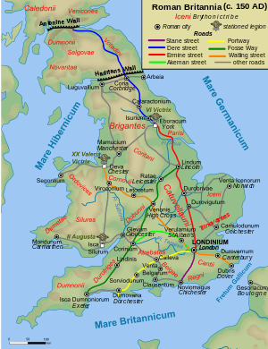
The earliest roads, built in the first phase of Roman occupation (the Julio-Claudian period 43–68 AD), connected London with the ports used in the invasion (Chichester and Richborough), and with the earlier legionary bases at Colchester, Lincoln (Lindum), Wroxeter (Viroconium), Gloucester and Exeter. The Fosse Way, from Exeter to Lincoln, was also built at this time to connect these bases with each other, marking the effective boundary of the early Roman province.
During the Flavian period (69–96 AD), the roads to Lincoln, Wroxeter and Gloucester were extended (by 80) to the new (and definitive) legionary bases at York, Chester and Caerleon respectively. By 96 further extensions from York to Corbridge, and from Chester to Carlisle and Caernarfon (Segontium), were completed as Roman rule was extended over Wales (Cambria) and northern England (Brigantia). Stanegate, the military road from Carlisle to Corbridge, was built under the Emperor Trajan (ruled 98–117 AD) along the line of the future Hadrian's Wall, which was constructed by his successor Hadrian in 122–132 AD.
Scotland (Caledonia), including England north of Hadrian's Wall, remained mostly outside the boundaries of Britannia province, as the Romans never succeeded in subjugating the entire island, despite a serious effort to do so by governor Gnaeus Julius Agricola in 82–84 AD. However, the Romans maintained a system of forts in the lowland region ca. 80–220 AD to control the indigenous population beyond Hadrian's Wall and annexed the Lowlands briefly with the construction of the Antonine Wall in 164. This barrier, across the 'neck' of Scotland, from the Firth of Clyde to the Firth of Forth, was held for some twenty years.
The Romans' main routes from Hadrian's Wall to the Antonine Wall, built by ca. 120 AD, were: (1) Corbridge to the Roman fort at Edinburgh (certain) and (likely) to Carriden (Veluniate) on the eastern end of the Antonine Wall, via High Rochester (Bremenium) and Melrose (Trimontium); (2) Carlisle to Bothwellhaugh (certain) and (likely) to the Antonine.
There was also a certain road beyond the Antonine Wall to Perth (Bertha) from the Antonine fort at Falkirk. Indeed, it has been thought that the Roman road to the north of the Forth, to Stirling and Perth, dates from the expedition of Severus to beyond the Dee, AD 209; it may, however, be doubted whether there was time in that campaign for such a work, and the road may well belong to a period before the construction of the Antonine Wall, AD 140.[3]
The core network was complemented by a number of routes built primarily for commercial, rather than military, purposes.
Examples include: in Kent and Sussex, three certain roads leading from London to the important iron-mining area of the Weald; and in East Anglia, the road from Colchester to Norwich, Peddars Way and the Fen Causeway. However, these Anglian and southern routes acquired military importance from the 3rd century onwards with the emergence of Saxon seaborne raiding as a major and persistent threat to the security of Britannia. These roads linked to the coastal defensive line of Saxon Shore forts e.g. Brancaster (Branodunum), Burgh Castle (Gariannonum) near Great Yarmouth, Lympne (Portus Lemanis) and Pevensey (Anderitum).
Construction and maintenance

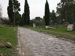
Standard Roman road construction techniques, long evolved on the Continent, were used. A road occupied a wide strip of land bounded by shallow ditches, varying in width from 86 pedes (25.5 m or 84 ft) on Ermin Way in Berkshire to 338 pedes (100 m or 330 ft) on Akeman Street in Oxfordshire. A trunk road in Britain would typically be 5–8 m (16–26 ft) in width, with a gauge of 7 m (23 ft) being the most common.[4] Watling Street was 10.1 m (33 ft) wide while the Fosse Way was little more than half that. Several unnamed roads were wider than Watling Street, such as the Silchester to Chichester road at 11.2 m (37 ft).[5]
In the centre a carriageway was built on a raised agger after stripping off soft topsoil, using the best local materials, often sand or sandy gravel. The two strips of ground between the agger and the boundary ditches were used by pedestrians and animals, and were sometimes lightly metalled. The agger was sometimes, but not always, bordered by deep ditches to take rainwater and keep the road structure as dry as possible.
The metalling was in two layers, a foundation of medium to large stones covered by a running surface, often a compacted mixture of smaller flint and gravel. About one quarter of road pavements were "bottomed" with large stones, mostly in the north and west where stone was more readily available. Some high-status roads in Italy were bound together by volcanic mortar, and a small minority of excavated sites in Britain have shown concrete or limestone mortar. Road surfaces in the iron-producing areas of the Weald were made from iron slag. The average depth of metalling over 213 recorded roads is about 51 cm (20 in), with great variation from as little as 10 cm (4 in) to up to 4 m (13 ft) in places, probably built up over centuries.
The main trunk roads were originally constructed by the Roman army. Responsibility for their regular repair and maintenance rested with designated imperial officials (the curatores viarum), though the cost would probably have been borne by the local civitas (county) authorities whose territory the road crossed. From time to time, the roads would be completely resurfaced and might even be entirely rebuilt, e.g. the complete reconstruction and widening of the Via Aemilia in northern Italy by the Emperor Augustus (reigned 37 BC - AD 14), two centuries after it was first built.
After the final withdrawal of Roman government and troops from Britain in 410, regular maintenance ended on the road network. Repairs became intermittent and based on ad hoc work. Despite the lack of any national management of the highways, Roman roads remained fundamental transport routes in England throughout the Early, High and Late Middle Ages. Systematic construction of paved highways did not resume until the building of the first turnpikes in the early 18th century.
Archaeological evidence

Extant remains of Roman roads are often much degraded or contaminated by later surfacing. Well-preserved sections of structures sometimes identified as Roman roads include Wade's Causeway in Yorkshire, and at Blackpool Bridge in the Forest of Dean, although their integrity as original Roman surfaces is not certain. In many places, Roman roads were built over in the 18th century to create the turnpikes. Where they have not been built over, many sections have been ploughed over by farmers and some stripped of their stone to use on turnpike roads.[6] However, there are numerous tracts of Roman road which have survived, albeit overgrown by vegetation, in the visible form of footpaths through woodland or common land. e.g. the section of Stane Street crossing Eartham Wood in the South Downs near Bignor (Sussex). This and others like it are marked on Ordnance Survey maps with dotted lines and the rubric "ROMAN ROAD". Peddars Way in Norfolk is a Roman road converted into a long-distance footpath.
Wayside stations have been identified in Britain. Roman roads had regularly spaced stations along their length - the Roman equivalent of motorway service areas. Roughly every 4 mi (6.4 km) - the most a horse could safely be ridden hard - there would be a mutatio (literally: "a change"), essentially stables where mounted messengers could change horses and a tavern to obtain refreshment. Cavalrymen from auxiliary mixed infantry- and cavalry- regiments (cohortes equitatae) provided most of the army's despatch-riders (dispositi). Relays of fresh riders and horses careering at full gallop could sustain an average speed of about 20 mph (32 km/h). Thus an urgent despatch from the army base at York to London - 200 mi (320 km), a journey of over a week for a normal mounted traveller - could be delivered in just 10 hours. Because mutationes were relatively small establishments, and their remains ambiguous, it is difficult to identify sites with certainty.
Approximately every 12 mi (19 km) - a typical day's journey for an ox-drawn wagon - was a mansio (literally: "a sojourn", from which derive the English word "mansion" and French maison or "house"). This was a full-scale wayside inn, with large stables, tavern, rooms for travellers and even bath-houses in the larger establishments. Mansiones also housed detachments of troops, primarily auxiliaries, which regularly garrisoned and patrolled the roads along their whole length. These would check the identities, travel permits and cargoes of road users. Mansiones may also have housed the agents of the imperial procurator (the chief financial officer in the province) who collected the portorium, an imperial toll on goods in transit on public roads that was charged at 2% - 2.5% of the value. The tax would be exacted when the goods crossed fixed toll points along the roads, which likely were located in or near mansiones.[7] At least half a dozen sites have been positively identified as mansiones in Britain. e.g. the excavated mansio at Godmanchester (Durovigutum) on Ermine Street (near Huntingdon, Cambridgeshire).[8]
Mutationes and mansiones were the key infrastructure for the cursus publicus (the imperial postal and transport system), which operated in many provinces of the Roman Empire. The cursus was primarily concerned with the carriage of government or military officers, government payload such as monies from tax collection and for military wages, and official despatches, but it could be made available to private individuals with special permission and for a fee. In Britain, the Vindolanda tablets, a series of letters written on wooden tablets to and by members of the garrison of Hadrian's Wall, show the operation of the cursus on the island.
Milestones, of which 95 are recorded in Roman Inscriptions of Britain.[9] Most of these date from the later part of the Roman period (250 AD onwards), since it was the practice to replace a road's milestones when a major repair was carried out. Milestones were usually cylindrical and 2–4 m (6 ft 7 in–13 ft 1 in) in height. Most contain only the customary dedication to the current Emperor and the number of miles to a particular destination. Only three provide additional information: two are dedicated by the public works departments of a civitas (county) (Dobunni)[10] and a city (Lincoln),[11] showing the involvement of local authorities in road maintenance; and the third[12] records that the Emperor Caracalla (r. 211-217) "restored the roads, which had fallen into ruin and disuse through old age".
Maps and Itineraries of the Roman era, designed to aid travellers, provide useful evidence of placenames, routes and distances in Britain. The most important is the Antonine Itinerary,[13] dating from the later 3rd century, which contains 14 itineraries on the island.
Road naming in post-Roman Britain
The original names of the Roman roads in Britain are not known due to the lack of written and inscribed sources. This is in contrast to surviving routes in Italy and other Roman provinces within western Europe. In Britain most route names are derived from the Welsh or Anglo-Saxon language. These were ascribed following the end of Roman rule in Britain (during the period known as the Early Middle Ages). This means that the English classification of a particular road does not reflect any of the original Roman nomenclature for naming highways within Britannia Superior or Britannia Inferior. For example, the Anglo-Saxons called the entire route from Dover/Portus Ritupis to Wroxeter, via Londinium (London): Watlingestrate (it is one of four former Roman roads (Latin: chemini) named as public rights of way under the Laws of Edward the Confessor in the early 11th century.[14][15]). However the Romans may have given each section of Saxon "Watling Street" entirely different names as the route was built sequentially over several decades in relation to the territory taken by the Romans as they subjugated Britain.
Official road names were usually taken from the Emperor in whose reign they were completed, e.g. the Via Traiana from Rome to Brindisi in southern Italy was named after the Emperor Trajan (r.98-117 AD). As the Dover to London section of Watling Street was begun in the years following the Roman invasion of Britain in 43 AD, it may have been known to the Romano-Britons as the Via Claudia in honour of Emperor Claudius (r.41-54 AD) who led the military campaign.
The only Anglo-Saxon name which might be etymologically linked to an original Roman name is the Fosse Way between Exeter and Lincoln. "Fosse" may derive from fossa, the Latin word for "ditch". But this is likely to be attributable to a popular, rather than official, Roman name for the route. Generally the Roman roads in Britain have names derived from Anglo-Saxon giants and divinities. For instance, Wade's Causeway in North Yorkshire is taken from Wōden, the supreme god of Germanic and Norse mythology.
English place names continue to reflect the settlement of Britain by the Anglo-Saxons. As these Germanic Pagan peoples advanced westward across the British isles, they encountered the decaying infrastructure of the former Roman Empire. Many settlements were founded on or near Roman roads (suffix -street e.g. Watling Street). The prefix strat-, strait-, streat- was employed to name settlements located near these former imperial highways. Stretham means "homestead or village on a Roman road" and likewise Stretford means "ford on a Roman road". There are seventeen places in England named Stretton.
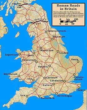
Main routes
The initial road network was built by the army to facilitate military communications. The emphasis was therefore on linking up army bases, rather than catering for economic flows.[16] Thus, three important cross-routes were established connecting the major legionary bases by AD 80 as the frontier of the Roman-occupied zone advanced:
- Exeter (Isca) – Lincoln (Lindum)
- Gloucester (Glevum) – York (Eboracum)
- Caerleon (Isca) – York via Wroxeter (Viroconium) and Chester (Deva)
Later a large number of other cross-routes and branches were grafted onto this basic network.
After Boudica's Revolt, London (Londinium) commanded the major bridge across the Thames connecting the final northern and western legionary bases with the Kentish ports communicating with Boulogne (Gesoriacum) and the rest of the Empire. Six core roads were constructed tying the new capital to the existing network. Ignoring their later English names, they are as follows:
- London – Canterbury (Durovernum). At Canterbury, this route split into 4 major branches to the major Roman ports:
- London – Chichester (Noviomagus), another port
- London – Silchester (Calleva Atrebatum). At Silchester, this route split into 3 major branches:
- Silchester – Portchester (Portus Adurni), another port, via Winchester (Venta) and Southampton (Clausentum)
- Silchester – Old Sarum (Sorviodunum), offering connections to Exeter and Dorchester (Durnovaria)
- Silchester – Caerleon, base of the 2nd legion, via Gloucester
- London – Chester, base of the 20th legion, via St Albans (Verulamium), Lichfield (Letocetum), and Wroxeter and with continuation to Carlisle (Luguvalium) on Hadrian's Wall
- London – York, base of the 9th and 6th legions, via Lincoln and with continuation to Corbridge (Coria) on Hadrian's Wall
- London – Colchester (Camulodunum), with continuation to Caistor St Edmund (Venta)
List of Roman Roads and modern numberings
- A.^ Sections of modern road that lie directly above the Roman road. Such stretches are marked "ROMAN ROAD" on Ordnance Survey Maps.
- B.^ Not to be confused with Icknield Way, a pre-Roman trackway from Buckinghamshire to Norfolk. Although the known road ends at Templeborough, it almost certainly continued to Doncaster (Danum) to join a branch of Ermine Street to York.
- C.^ This is not a Saxon name, but a Latin one invented by 18th century antiquarians to define a putative route. It amounts to just a series of cross routes to reach Watling Street from Colchester.
See also
Notes
- ↑ Map of Roman Britain, Ordnance Survey
- ↑ Morris, Steven (15 March 2011). "Britannia Superior: Why Roman roads may not be quite as Roman as we think". The Guardian. Retrieved 16 March 2011.
- ↑ Roman road to Stirling and Perth
- ↑ L.V. Grinsell, The Archaeology of Wessex (1958), p.255
- 1 2 Hugh Davies, (2002) Roads in Roman Britain Tempus Publishing ISBN 978-0-7524-2503-0
- ↑ The course of the London to Brighton Roman road south of Burgess Hill by Glen Shields p86
- ↑ J. Wacher (ed.), The Roman World (1987) Vol. I. 428. Vindolanda tablets 154, a renuntia (daily deployment report) of auxiliary regiment cohors I Tungrorum, records the absence from regimental base of 3 small detachments of 6-11 men, each under the command of a centurion, at indeciphrable locations, possibly mansiones
- ↑ Green, M, "Godmanchester Roman History - The Mansio", Current Archaeology, number 16, September 1969 pp133-138
- ↑ Collingwood RG, Wright RP, The Roman Inscriptions of Britain (RIB 2219 - 2314)
- ↑ RIB 2250
- ↑ RIB 2240
- ↑ RIB 2228
- ↑ Antonine Itinerary, roman-britain.org
- 1 2 "Leges Edwardi Confessoris (ECf1), §12", Early English Laws, London: University of London, 2015, retrieved 20 February 2015 (Latin)
- ↑ The other three were "Fosse", "Hikenildestrate" (Icknield Street), and "Herningestrate" (Ermine Street).[14]
- ↑ Cambridge Ancient History, Vol, The Augustan Empire
- ↑ "Worsted Street (Via Devana) Roman road". Heritage Gateway. Retrieved 4 March 2015.
References
Margary, Ivan D. (1973), Roman Roads in Britain (third ed.), London: John Baker, ISBN 0-212-97001-1
External links
- Codrington, Thomas (1918), Roman Roads in Britain (Third ed.), London: Society for Promoting Christian Knowledge (published 1919)
- Parthey, Gustav; Pinder, Moritz, eds. (1848), Itinerarium Antonini Augusti et Hierosolymitanum, Berlin
- Reynolds, Thomas (1799), Iter Britanniarum, Cambridge
- Codrington's Roman Roads in Britain
- Channel 4's big Roman dig
- Info Britain.co.uk
- Maps of Roman Roads in Britain: 1, 2
- Roman road route planner, British part based on Itinerarium Antonini
- News story about road through Puddletown forest
- 'Lost' Roads of Ancient Rome Discovered with 3D Laser Scanners