Little Bitterroot Lake, Montana
| Little Bitterroot Lake, Montana | |
|---|---|
| Census-designated place | |
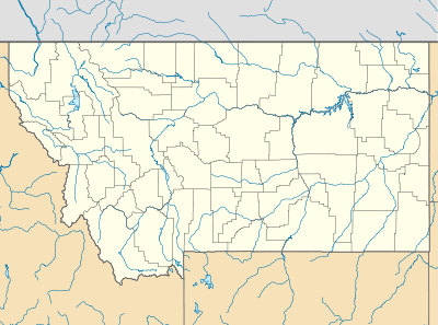 Little Bitterroot Lake Location of Little Bitterroot Lake, Montana | |
| Coordinates: 48°7′31″N 114°43′55″W / 48.12528°N 114.73194°WCoordinates: 48°7′31″N 114°43′55″W / 48.12528°N 114.73194°W | |
| Country | United States |
| State | Montana |
| County | Flathead |
| Area | |
| • Total | 13.14 sq mi (34.04 km2) |
| • Land | 8.42 sq mi (21.82 km2) |
| • Water | 4.72 sq mi (12.22 km2) |
| Elevation | 4,022 ft (1,226 m) |
| Population (2010) | |
| • Total | 194 |
| • Density | 15/sq mi (5.7/km2) |
| Time zone | Mountain (MST) (UTC-7) |
| • Summer (DST) | MDT (UTC-6) |
| Area code(s) | 406 |
| GNIS feature ID | 2583823[1] |
Little Bitterroot Lake is a census-designated place (CDP) in Flathead County, Montana, United States. The population was 194 at the 2010 census.[2]
References
Municipalities and communities of Flathead County, Montana, United States | ||
|---|---|---|
| Cities | 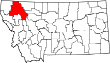 | |
| CDPs | ||
| Unincorporated communities | ||
| Indian reservation | ||
| Footnotes | ‡This populated place also has portions in an adjacent county or counties | |
This article is issued from Wikipedia - version of the 6/7/2016. The text is available under the Creative Commons Attribution/Share Alike but additional terms may apply for the media files.