Batavia, Montana
| Batavia, Montana | |
|---|---|
| Census-designated place | |
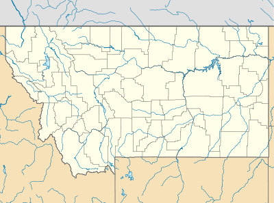 Batavia Location of Batavia, Montana | |
| Coordinates: 48°10′39″N 114°24′26″W / 48.17750°N 114.40722°WCoordinates: 48°10′39″N 114°24′26″W / 48.17750°N 114.40722°W | |
| Country | United States |
| State | Montana |
| County | Flathead |
| Area | |
| • Total | 1.80 sq mi (4.65 km2) |
| • Land | 1.80 sq mi (4.65 km2) |
| • Water | 0.00 sq mi (0.00 km2) |
| Elevation | 3,136 ft (956 m) |
| Population (2010) | |
| • Total | 385 |
| • Density | 210/sq mi (83/km2) |
| Time zone | Mountain (MST) (UTC-7) |
| • Summer (DST) | MDT (UTC-6) |
| Area code(s) | 406 |
| GNIS feature ID | 2583787[1] |
Batavia is a census-designated place (CDP) in Flathead County, Montana, United States. The population was 385 at the 2010 census.[2]
References
- ↑ U.S. Geological Survey Geographic Names Information System: Batavia, Montana
- ↑ "American FactFinder". United States Census Bureau. Archived from the original on 2013-09-11. Retrieved 2011-05-14.
Municipalities and communities of Flathead County, Montana, United States | ||
|---|---|---|
| Cities | 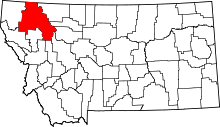 | |
| CDPs | ||
| Unincorporated communities | ||
| Indian reservation | ||
| Footnotes | ‡This populated place also has portions in an adjacent county or counties | |
This article is issued from Wikipedia - version of the 10/28/2016. The text is available under the Creative Commons Attribution/Share Alike but additional terms may apply for the media files.