Mythology and legacy of Benjamin Banneker
A substantial mythology exaggerating Benjamin Banneker's accomplishments has developed during the two centuries that have elapsed since he lived.[1][2] Several such urban legends describe Banneker's alleged activities in the Washington, D.C. area around the time that he assisted Andrew Ellicott in the federal district boundary survey.[2][3][4][5] Others involve his clock, his almanacs and his journals.[2] All lack support by historical evidence. Some are contradicted by such evidence.
A United States postage stamp and the names of a number of recreational and cultural facilities, schools, streets and other facilities and institutions throughout the United States have commemorated Banneker's documented and mythical accomplishments throughout the years since he lived.
Mythology of Benjamin Banneker
Plan of the City of Washington
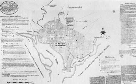
While Andrew Ellicott and his team were conducting the federal district boundary survey in 1791-1792 (see: Boundary Markers of the Original District of Columbia), Pierre (Peter) Charles L'Enfant was preparing a plan for the federal capital city (the City of Washington), which would be located in a relatively small area bounded by the Potomac River, the Anacostia River (known at the time as the "Eastern Branch"), the base of the escarpment of the Atlantic Seaboard Fall Line, and Rock Creek at the center of the much larger 100-square-mile (260 km2) federal district (known at the time as the "Territory of Columbia") (see: L'Enfant Plan and History of Washington, D.C.#Founding).[6][7][8][9] In late February 1792, President George Washington dismissed L'Enfant, who had failed to have his plan published and who was experiencing frequent conflicts with the three Commissioners that Washington had appointed to supervise the planning and survey of the federal district and city.[8][10][11]
A number of undocumented stories connecting Banneker and L'Enfant's plan for the federal capital city have appeared over the years. In 1929, when describing the ceremonial presentation to Howard University in Washington, D.C., of a sundial memorializing Banneker, the Chicago Defender newspaper reported that a speaker had stated that:
.... he (Banneker) was appointed by President George Washington to aid Major L'Enfant, famed French architect, to plan the layout of the District of Columbia. L'Enfant died before the work was completed, which required Banneker to carry on in his stead.[12]
However, as a book that won the 1917 Pulitzer Prize for History had earlier reported, L'Enfant lived long after he developed his plan for the federal capital city. He died near the City of Washington in 1825.[13]
According to a similar Banneker legend, L'Enfant took his plans with him after his dismissal, leaving no copies behind. As the story is told, Banneker spent two days reconstructing the bulk of the city's plan from his presumably photographic memory. In this story, the plans that Banneker purportedly drew from memory provided the basis for the later construction of the federal capital city. Titles of works relating this fable have touted Banneker as "The Man Who Designed Washington", "The Man Who Saved Washington", "An Early American Hero", "Benjamin Banneker, Genius", and as one of "100 Greatest African Americans".[14]
In another version of the tale, Banneker and Andrew Ellicott both surveyed the area of, and configured the final layout for, the placement of major governmental buildings, boulevards and avenues while reconstructing L'Enfant's plan or on another occasion. According to this version, Banneker either "made astronomical calculations and implementations" that established points of significance in the capital city, including those of the "16th Street Meridian" (see White House meridian), the White House, the Capitol and the Treasury Building, or "helped in selecting the sites" of those features.[15]
A U.S. Treasury Department, Section of Fine Arts, mural in the Recorder of Deeds Building, which was constructed from 1940 to 1943 in Washington, D.C., perpetuates a Banneker legend by showing Banneker with a plan of the City of Washington.[16] The oil portrait was the winner of a juried competition that the Section held on behalf of Doctor William J. Tompkins, an African American political figure who was at the time serving as the Recorder of Deeds. The competition announcement stated that seven mural subjects had been “carefully worked out by the Recorder...following intensive research” to "reflect a phase of the contribution of the Negro to the American nation.” A mural on the subject of “Benjamin Banneker Surveys the District of Columbia” was to “show the presentation by Banneker and Mayor Ellicott, of the plans of the District of Columbia to the President, [and] Mr. Thomas Jefferson” in the presence of Benjamin Franklin and Alexander Hamilton.[17]
Citing a 1963 article in the Washington Star newspaper,[18] a 1990 documentation form related the following version of the story when supporting a listing in the National Register of Historic Places for twelve historic marker stones from the federal district boundary survey:
.... Fearing profiteering land speculators, L'Enfant would not allow anyone to see the plan. Ordered by the commissioners to reveal the plan, he instead left the United States, taking all copies of his plan for the District of Columbia with him. Banneker reproduced it from memory in minute detail, thereby allowing the work to continue.[19]
In 1976, an Afro-American Bicentennial Corporation historian told the following story within a National Register of Historic Places nomination form for the "Benjamin Banneker: SW-9 Intermediate Boundary Stone (milestone) of the District of Columbia":
.... Major L'Enfant resigned his position before the planned design was completed. It was only through the efforts of Major Andrew Ellicott and Benjamin Banneker that the Federal City was completed.[20]
However, historical research has shown that none of these legends can be correct.[3][21] Ellicott's 1791 assignment was to produce a survey of a square, the length of whose sides would each be 10 miles (16.1 km) (a "ten mile square").[6] L'Enfant was to survey, design and lay out the national capital city within this square.[6][22] Ellicott and L'Enfant each worked independently under the supervision of the three Commissioners that President Washington had earlier appointed.[6] Ellicott employed Banneker directly.[6] A researcher could find no evidence that Banneker ever worked with or for L'Enfant.[6]

Banneker left the federal capital area and returned to his home at Ellicott's Mills in April 1791.[3][23] At that time, L'Enfant was still developing his plan for the federal city and had not yet been dismissed from his job.[3][24] L'Enfant presented his plans to President Washington in June and August 1791, two and four months after Banneker had left.[3][25][26][27][28]
Further, there never was any need to reconstruct L'Enfant's plan. After completing the initial phases of the district boundary survey, Andrew Ellicott began to survey the federal city to help L'Enfant develop the city's plan.[29] During a contentious period in February 1792, Ellicott informed the Commissioners that L'Enfant had refused to give him an original plan that L'Enfant possessed at the time.[30][31] However, L' Enfant had earlier given to Washington at least two versions of his plan, one of which Washington had presented to Congress in December 1791.[25][26] Andrew Ellicott, with the aid of his brother, Benjamin Ellicott, then revised L'Enfant's plan, despite L'Enfant's protests.[5][30][31] Shortly thereafter, Washington dismissed L'Enfant. After L'Enfant departed, the Commissioners assigned Ellicott the dual responsibility for continuing L'Enfant's work on the design of the city and the layout of public buildings, streets and property lots, in addition to completing the boundary survey.[6] Andrew Ellicott therefore continued the city survey in accordance with the revised plan that he and his brother had prepared.[10][25][32]
There is no historical evidence that shows that Banneker was involved in any of this.[5] As a researcher has reported, the letter that Andrew Ellicott addressed to the Commissioners in February 1792 describing his revision of L'Enfant's plan did not mention Banneker's name.[5][33] Thomas Jefferson did not describe any connection between Banneker and the plan for the federal city when relating his knowledge of Banneker's works in a letter that he sent to Joel Barlow in 1809, three years after Banneker's death.[34]
L'Enfant did not leave the United States after ending his work on the federal capital city's plan. Soon afterwards, he began to plan the city of Paterson, New Jersey.[35] The United States Congress acknowledged the work that he had performed when preparing his plan for the city of Washington by voting to pay him for his efforts.[36]
A 1914 book describing the history of the City of Washington reported that L'Enfant's plan contained a title legend that identified L'Enfant as the plan's author.[37] A 1902 report of a committee of the United States Senate (the McMillan Plan), an inlay of a city plan in a Washington, D.C., plaza constructed in 1980 (Freedom Plaza), and at least one book relating the history of the District of Columbia contain copies of the portion of a plan for the federal capital city that identifies "Peter Charles L'Enfant" (L'Enfant's adopted name) as the plan's author.[7][38][a 1] The U.S. Library of Congress owns a copy of a plan for the federal city whose last line in an oval in the plan's upper left hand corner identifies the document's author as "Peter Charles L'Enfant".[39] The U.S. National Archives holds a copy of "Ellicott's engraved Plan superimposed on the Plan of L'Enfant showing the changes made in the engraved Plan under the direction of President Washington".[40] As an original version of L'Enfant's plan still exists, President Washington and Ellicott clearly had at least one such version available for their use when L'Enfant departed.
In November 1971, the National Park Service held a public ceremony to dedicate and name Benjamin Banneker Park on L'Enfant Promenade in Washington, D.C.[41][42] The U.S. Department of Interior authorized the naming as an official commemorative designation celebrating Banneker's role in the survey and design of the nation’s capital.[41] Speakers at the event hailed Banneker for his contributions to the plan of the capital city after L'Enfant's dismissal, claiming that Banneker had saved the plan by reconstructing it from memory.[42] A researcher later pointed out that these statements were erroneous.[42]
In May 2000, Austin H. Kiplinger and Walter E. Washington, the co-chairmen of the Leadership Committee for the planned City Museum of Washington, D.C., wrote in The Washington Post that the museum would remind visitors that Banneker had helped complete L'Enfant's project to map the city.[43] A letter to the editor of the Post entitled "District History Lesson" then responded to this statement by noting that Andrew Ellicott was the person who revised L'Enfant's plan and who completed the capital city's mapping, and that Banneker had played no part in this.[44]
Appointment to planning commission for Washington, D.C.
In 1918, Henry E. Baker, an assistant examiner in the United States Patent Office, wrote of Banneker in The Journal of Negro History (now titled The Journal of African American History): "It is on record that it was on the suggestion of his friend, Major Andrew Ellicott, ..., that Thomas Jefferson nominated Banneker and Washington appointed him a member of the commission..." whose duties were to "define the boundary line and lay out the streets of the Federal Territory, later called the District of Columbia".[45] However, Baker did not identify the record on which he based this statement. Baker additionally stated that Andrew Ellicott and L'Enfant were also members of this commission.
In 2000, historians John Hope Franklin and Alfred A. Moss, Jr., wrote in the eighth edition of the book, From Slavery to Freedom: A History of African Americans, whose first edition had been published in 1947, that the "most distinguished honor that Banneker received was his appointment to serve with the commission to define the boundary lines and lay out the streets of the District of Columbia." The writers, who referenced Baker's 1918 article, also stated that Banneker's friend, George Ellicott (Andrew Ellicott's cousin), was a member of the commission and that Thomas Jefferson had submitted Banneker's name to President Washington.[46]
In 2005, actor James Avery narrated a DVD entitled A History of Black Achievement in America. A quiz based on a section of the DVD entitled "Emergence of the Black Hero" asked:
Benjamin Banneker was a member of the planning commission for ____________ .
a. New York City
b. Philadelphia
c. Washington, D.C.
d. Atlanta[47]
However, historical evidence contradicts the statements that Baker, Franklin and Moss made and suggests that the question in the quiz has no correct answer. In 1791, President Washington appointed Thomas Johnson, Daniel Carroll and David Stuart to be the three commissioners who, in accordance with the authority that the federal Residence Act of 1790 had granted to the President, would oversee the survey of the federal district, and "according to such Plans, as the President shall approve", provide public buildings to accommodate the federal government in 1800.[48][49][50]
The Residence Act did not authorize the President to appoint any more than three commissioners that could serve at the same time.[51] As Banneker, Andrew Ellicott, and L'Enfant performed their tasks during the time that Johnson, Carroll and Stuart were serving as commissioners, President Washington could not have legally appointed either Banneker, Ellicott or L'Enfant to serve as members of the "commission" that Baker, Franklin and Moss described.
Further, Franklin and Moss did not cite any documentation to support their contention that George Ellicott participated in the planning and design of the nation's capital. Andrew (not George) Ellicott led the survey that defined the District's boundary lines and, with L'Enfant, laid out the capital city's streets. Additionally, there is no historical evidence that shows that President Washington participated in the process that resulted in Banneker's appointment as an assistant to Andrew Ellicott on the District boundary survey team.[52]
In 1999, a researcher reported that an exhaustive survey of U.S. government repositories, including the Public Buildings and Grounds files in the National Archives and collections in the Library of Congress, had failed to identify Banneker's name on any contemporary documents or records relating to the selection, planning and survey of the City of Washington. The researcher also noted that none of L'Enfant's survey papers that the researcher had found had contained Banneker's name.[53] Another researcher has been unable to find any documentation that shows that Washington and Banneker ever met.[54]
Boundary markers of the District of Columbia
During 1791 and 1792, a survey team that Andrew Ellicott led placed forty mile marker stones along the 10 miles (16.1 km)-long sides of a square that would form the boundaries of the future District of Columbia, beginning at the square's south corner at Jones Point in Alexandria, Virginia (see Boundary Markers of the Original District of Columbia).[8][55] On May 8, 2015, a Washington Post article describing a rededication ceremony for one of the marker stones reported that a regent of a chapter of the D.C. Daughters of the American Revolution had said:
These stones are our nation’s oldest national landmarks that were placed by Andrew Ellicott and Benjamin Banneker. They officially laid the seat of government of our new nation.[56]
A May 30, 2015, the web version of a follow-up article in the Post carried the headline "Stones laid by Benjamin Banneker in the 1790s are still standing".[57] Disputing the headline's information, a June 1, 2015, comment following the article stated while citing an extensively referenced source[58] that Banneker had made the astronomical observations and calculations needed to establish the location of the south corner of the District's square, but had not participated in any later parts of the square's survey.[59] (Banneker left the federal capital area and returned to his home at Ellicott's Mills in late April 1791, shortly after the south cornerstone was set in place during an April 15, 1791, ceremony.)[60] Nevertheless, in 2016, a columnist writing in a Falls Church, Virginia, newspaper stated that Banneker had placed a District boundary stone in the writer's Arlington County, Virginia, neighborhood.[61]
A 2016 booklet that the government of Arlington County, Virginia, published to promote the County's African American history stated, "On April 15, 1791, officials dedicated the first boundary stone based on Banneker's calculations."[62] However, it was actually a March 30, 1791, presidential proclamation by George Washington that established ″Jones's point, the upper cape of Hunting Creek in Virginia″ as the starting point for the federal district's boundary survey.[63] Washington did not need any calculations to determine the location of Jones Point. Further, according to an April 21, 1791, news report of the dedication ceremony for the first boundary stone (the south cornerstone), it was Andrew Ellicott who ″ascertained the precise point from which the first line of the district was to proceed". The news report did not mention Banneker's name.[64]
Banneker's clock
In 1902, a professor of mathematics at Howard University, Kelly Miller, wrote in a United States Bureau of Education publication that Banneker had in 1770 "constructed a clock to strike the hours, the first to be made in America".[65] In contrast, Phillip Lee Phillips, a Library of Congress librarian,[66] more cautiously stated in a 1916 paper read before the Columbia Historical Society in Washington, D.C. that Banneker "is said to have made, entirely with his own hand, a clock of which it is said every portion was made in America."[67]
In 1980, the United States Postal Service (USPS) issued a postage stamp that commemorated Banneker. The USPS' description of Banneker stated: "... In 1753, he built the first watch made in America."[68] A 2004 USPS pamphlet illustrating the stamp stated that Banneker "constructed the first wooden striking clock made in America."[69] The website of the Banneker-Douglass Museum, the State of Maryland's official museum of African American heritage, similarly claimed in 2015 that Banneker crafted "the first wooden striking clock in America".[70]
In 2015, columnists Al Kamen and Colby Itkowitz wrote in the Washington Post that Banneker was "an African American inventor".[71] However, while several 19th, 20th and 21st century biographers have written that Banneker constructed a clock, none of these alleged that Banneker invented a timepiece or anything else. None stated that Banneker's clock had any characteristics that earlier American clocks had lacked.[72]
Documents describing the history of clockmaking in America show that Banneker's clock was not the first of its kind made in America. Connecticut clockmakers were crafting striking clocks throughout the 1600s, before Banneker was born.[73] The Metropolitan Museum of Art in New York City holds in its collections a striking clock that Benjamin Bagnall constructed in Boston before 1740 (when Banneker was 9 years old) and that Elisha Williams probably acquired between 1725 and 1739 while he was rector of Yale College.[74]
There is some evidence that wooden clocks were being made as early as 1715 near New Haven, Connecticut.[73][75] Benjamin Cheney of East Hartford, Connecticut, was producing wooden striking clocks by 1745, eight years before Banneker completed his own wooden striking clock in 1753.[73][75][76][77]
Banneker's almanacs
In addition to incorrectly describing Banneker's clock, Kelly Miller's 1902 publication stated that Banneker's 1792 almanac for Pennsylvania, Virginia and Maryland was "the first almanac constructed in America".[65] The National Register of Historic Places nomination form for the ″Benjamin Banneker: SW-9 Intermediate Boundary Stone (milestone) of the District of Columbia" that an Afro-American Bicentennial Corporation historian prepared in 1976 similarly states that Banneker's astronomical calculations "led to his writing one of the first series of almanacs printed in the United States."[78]
However, William Pierce's An Almanac Calculated for New England, printed in 1639 by Stephen Day in Cambridge, Massachusetts, preceded Banneker's birth by nearly a century.[79] Benjamin Franklin published his annual Poor Richard's Almanack in Philadelphia, Pennsylvania, from 1732 to 1758, more than thirty years before Banneker wrote his own first almanac in 1791.[80]
Seventeen-year cicada
In 2004, during a year in which Brood X of the seventeen-year periodical cicada (Magicicada septendecim) emerged from the ground in large numbers, columnist Courtland Milloy wrote in The Washington Post an article entitled "Time to Create Some Buzz for Banneker".[81] Milloy claimed that Banneker "is believed to have been the first person to document this noisy recurrence" of the insect. Milloy stated that Banneker had recorded in a journal "published around 1800" that the "locusts" had appeared in 1749, 1766 and 1783. Milloy further noted that Banneker had predicted that the insects would return in 1800.[82] In 2014, the authors of an online publication that reproduced Banneker's handwritten journal report cited Milloy's article and contended that "Banneker was one of the first naturalists to record scientific information and observations of the seventeen-year cicada".[83]
However, earlier published accounts of the periodical cicada's life cycle describe the history of cicada sightings differently. These accounts cite descriptions of fifteen- to seventeen-year recurrences of enormous numbers of noisy emergent cicadas that people had written as early as 1737,[84][85] when Banneker was six years old.
Pehr Kalm, a Swedish naturalist visiting Pennsylvania and New Jersey in 1749 on behalf of his nation's government, observed in late May the first of the three Brood X emergences that Banneker's journal later documented.[84][86] When reporting the event in a paper that a Swedish academic journal published in 1756, Kalm wrote:
The general opinion is that these insects appear in these fantastic numbers in every seventeenth year. Meanwhile, except for an occasional one which may appear in the summer, they remain underground.
There is considerable evidence that these insects appear every seventeenth year in Pennsylvania.[86]
Kalm then described documents (including one that he had obtained from Benjamin Franklin) that had recorded in Pennsylvania the emergence from the ground of large numbers of cicadas during May 1715 and May 1732. He noted that the people who had prepared these documents had made no such reports in other years.[86] Kalm further noted that others had informed him that they had seen cicadas only occasionally before the insects appeared in large swarms during 1749.[86] He additionally stated that he had not heard any cicadas in Pennsylvania and New Jersey in 1750 in the same months and areas in which he had heard many in 1749.[86] The 1715 and 1732 reports, when coupled with his own 1749 and 1750 observations, supported the previous "general opinion" that he had cited.
Kalm summarized his observations and conclusions in a paper translated into English in 1771, in which he cited his 1756 Swedish publication[87] and stated:
There are a kind of locusts which about every seventeen years come hither in incredible numbers .... In the interval between the years when they are numerous, they are only seen or heard single in the woods.[84][88]
In 1758, Carl Linnaeus gave to the insect that Kalm had described the Latin name of Cicada septendecim (seventeen-year cicada) in the tenth edition of his Systema Naturae.[89] Banneker's second observation of a Brood X emergence occurred eight years later.
Other legends and embellishments
In 1930, writer Lloyd Morris claimed in an academic journal article entitled The Negro "Renaissance" that "Benjamin Banneker attracted the attention of a President.... President Thomas Jefferson sent a copy of one of Banneker's almanacs to his friend, the French philosopher Condorcet....".[90] However, Thomas Jefferson sent Banneker's almanac to the Marquis de Condorcet in 1791, a decade before he became President in 1801.[91][92]

In 1943, an African American artist, Charles Alston, who was at the time an employee of the United States Office of War Information, designed a cartoon that embellished the statements that Henry E. Baker had made in 1918.[45] Like Baker, Alston incorrectly claimed that Banneker "was placed on the commission which surveyed and laid out the city of Washington, D.C." Alston extended this claim by also stating that Banneker had been a "city planner". Alston's cartoon additionally extended a claim that Kelly Miller had made in 1902[65] by stating that Banneker had "constructed the first clock made in America".[93]
In 1976, the singer-songwriter Stevie Wonder celebrated Banneker's mythical feats in his song "Black Man", from the album Songs in the Key of Life. The lyrics of the song state:
Who was the man who helped design the nation's capitol, Made the first clock to give time in America and wrote the first almanac? Benjamin Banneker, a black man[94]
The question's answer is incorrect. Banneker did not help design either the U.S. Capitol or the nation's capital city and did not write America's first almanac. The first known clockmaker of record in America was Thomas Nash, an early settler of New Haven in 1638.[73]
In 1998, a Catalan writer, Núria Perpinyà, created a fictional character, Aleph Banneker, in her novel Un bon error (A Good Mistake). The writer's website reported that the character, an "eminent scientist", was meant to recall Benjamin Banneker, an eighteenth-century "black astronomer and urbanist".[95] However, none of Banneker's documented activities or writings suggest that he was an "urbanist".[96]
In 1999, the National Capital Memorial Commission concluded that the relationship between Banneker and L’Enfant was such that L’Enfant Promenade was the most logical place in Washington, DC on which to construct a proposed memorial to Banneker.[97] However, a researcher has been unable find any historical evidence that shows that Banneker had any relationship at all to L'Enfant or to L'Enfant's plan for the city, although he wrote that the two men "undoubtedly" met each other after L'Enfant arrived in Georgetown in March 1791 to begin his work.[42][53][98]

A history painting by Peter Waddell entitled A Vision Unfolds debuted in 2005 within an exhibition on Freemasonry that the Octagon House's museum in Washington, D.C., was hosting. The oil painting was again displayed in 2007, 2009, 2010 and 2011, first in the Joslyn Art Museum in Omaha, Nebraska and later in the National Heritage Museum in Lexington, Massachusetts and in the Scottish Rite Center of the District of Columbia in Washington, D.C.[99] Waddell's painting contains elements present in Edward Savage's 1789-1796 painting The Washington Family, which portrays President George Washington and his wife Martha viewing a plan of the City of Washington.[100]
A Vision Unfolds depicts a meeting that is taking place within an elaborate surveying tent. In the imaginary scene, Banneker presents a map of the Territory of Columbia to President Washington and Andrew Ellicott.[99]
However, Andrew Ellicott completed his survey of the territory's boundaries in 1792.[6][8] On January 1, 1793, Ellicott submitted to the three commissioners "a report of his first map of the four lines of experiment, showing a half mile on each side, including the district of territory, with a survey of the different waters within the territory".[101] The Library of Congress has attributed to 1793 Ellicott's earliest map of the Territory of Columbia that the Library holds within its collections.[102] As Banneker left the federal capital area in 1791,[3][23] Banneker could not have had any association with the map that Waddell depicted. Further, a researcher has been unable to find any documentation that shows that President Washington and Banneker ever met.[54]
Commemorative U.S. quarter dollar coin nomination
In 2008, the District of Columbia government considered selecting an image of Banneker for the reverse side of the District of Columbia quarter in the 2009 District of Columbia and United States Territories Quarter Program. The narrative supporting this selection alleged that Banneker helped design the new capital city, was "among the first ever African-American presidential appointees" and was "a founder of Washington, D.C."[103] After the District chose to commemorate another person on the coin, the District's mayor, Adrian M. Fenty, sent a letter to the Director of the United States Mint, Edmund C. Moy, that claimed that Banneker "played an integral role in the physical design of the nation's capital."[104] However, no president ever appointed Banneker to any position. Further, Banneker played no role at all in the design, development or founding of the nation's capital beyond his three-month participation in the two-year survey of the federal district's boundaries.[34][105]
Historical markers
Several historical markers in Maryland and Washington, D.C., contain information relating to Benjamin Banneker that is unsupported by historical evidence or is contradicted by such evidence:
Historical marker in Benjamin Banneker Historical Park, Baltimore County, Maryland
A commemorative historical marker that the Maryland Historical Society erected on the present grounds of Benjamin Banneker Historical Park in Baltimore County, Maryland, states that Banneker "published the first Maryland almanac" in 1792.[106] A researcher has reported that this statement is incorrect.[107] The researcher stated that Banneker modeled the format of his almanac after a series of almanacs (The United States Almanack) that Andrew Ellicott had authored from 1781 to 1785.[108][109] Ellicott had lived in Maryland during some of those years.[108] Ellicott's almanacs were published in Baltimore, Maryland.[110]
Further, Banneker did not "publish" his 1792 almanac. Although he authored this work, others printed, distributed and sold it.[111]
Historical marker in Benjamin Banneker Park, Washington, DC
A historical marker that the National Park Service erected in Benjamin Banneker Park in Washington, D.C., states in an unreferenced paragraph:
Banneker became intrigued by a pocket watch he had seen as a young man. Using a knife he intricately carved out the wheels and gears of a wooden timepiece. The remarkable clock he constructed from memory kept time and struck the hours for the next fifty years.[112][113]
However, Banneker completed his clock at the age of 22, when he was still a young man.[77] No historical evidence shows that he constructed the clock from memory.[114]
Further, it is open to question as to whether the clock was actually "remarkable". A researcher has noted that at least four clockmakers were working in Annapolis, Maryland, before 1753, when Banneker completed his own clock.[115]
A photograph on the historical marker illustrates a wooden striking clock that Benjamin Cheney constructed around 1760.[112][116] The marker does not indicate that the clock is not Banneker's.[112]
Historical marker in Newseum, Washington, DC
In 2008, when the Newseum opened to the public on Pennsylvania Avenue in Washington, D.C., visitors looking over the Avenue could read a historical marker that stated:
Benjamin Banneker assisted Chief Surveyor Andrew Ellicott in laying out the Avenue based on Pierre L’Enfant’s Plan. President George Washington appointed Ellicott and Banneker to survey the boundaries of the new city.[117]
Little or none of this appears to be correct. Banneker had no involvement with the laying out of Pennsylvania Avenue or with L’Enfant’s Plan.[3] Andrew Ellicott surveyed the boundaries of the federal district (not the “boundaries of the new city”) at the suggestion of Thomas Jefferson.[49] Ellicott (not Washington) appointed Banneker to assist in the boundary survey.[6][52]
Commemorations of Benjamin Banneker
A United States postage stamp and the names of a number of recreational and cultural facilities, educational institutions, streets and other facilities and institutions throughout the United States have commemorated Banneker's documented and mythical accomplishments throughout the years since he lived.
Benjamin Banneker postage stamp
On February 15, 1980, during Black History Month, the United States Postal Service issued in Annapolis, Maryland, a 15 cent commemorative postage stamp that featured a portrait of Banneker.[69][118] An image of Banneker standing behind a short telescope mounted on a tripod was superimposed upon the portrait.[69][119] The device shown in the stamp resembles Andrew Ellicott's transit and equal altitude instrument (see Theodolite), which is presently in the collection of the Smithsonian Institution's National Museum of American History in Washington, D.C.[120]
The stamp was the third in the Postal Service's Black Heritage stamp series.[69][121] The featured portrait was one that Jerry Pinkney of Croton-on-Hudson, New York, who designed the first nine stamps in the series, had earlier placed on another approved version of the stamp.[122] A Banneker biographer subsequently noted that, because no known portrait of Banneker exists, the stamp artist had based the portrait on "imagined features".[105]
Recreational and cultural facilities
The names of a number of recreational and cultural facilities commemorate Banneker. These facilities include parks, playgrounds, community centers, museums and a planetarium.
Parks
Benjamin Banneker Historical Park and Museum, Baltimore County, Maryland
A park commemorating Benjamin Banneker is located in a stream valley woodland at the former site of Banneker's farm and residence in Oella, Maryland, between Ellicott City and the City of Baltimore.[a 2] The Baltimore County Department of Recreation and Parks manages the $2.5 million facility, which was dedicated on June 9, 1998.[123] The park, which encompasses 138 acres (56 ha) and contains archaeological sites and extensive nature trails, is the largest original African American historical site in the United States.[124] The primary focus of the park is a museum highlighting Banneker's contributions. The museum contains a visitors center that features a collection of Banneker's works and artifacts, a community gallery, a gift shop and a patio garden.[124][125]
On November 12, 2009, officials opened a 224 square feet (20.8 m2) replica of Banneker's log cabin on the park grounds, reportedly two days before the 278th anniversary of Banneker's birth.[126] Baltimore County's delegation to the Maryland General Assembly secured a $400,000 state bond for the design and construction of the cabin.[127] The original estimated cost to construct the cabin in accordance with its drawings and specifications was $240,700.[128]
A historical marker that the Maryland Historical Society erected to commemorate Banneker stands on the grounds of the park.[106] The marker replaced the last of three earlier markers that vandals had previously destroyed.[129]
Benjamin Banneker Park and Memorial, Washington, D.C.


A 4.7 acres (1.9 ha) urban park memorializing Benjamin Banneker is located inside a traffic circle, named Benjamin Banneker Circle, at a prominent overlook near the Potomac River waterfront at the south end of L'Enfant Promenade in southwest Washington, D.C. The park is a half mile (800 m) south of the Smithsonian Institution's "Castle" on the National Mall.[41][130][a 3] The National Park Service owns the park and has erected a historical marker there.[112][130][131][132] The park, which was constructed in 1970 as the "Tenth Street Overlook", dedicated in 1971 as "Benjamin Banneker Park", and rededicated in 1997, is now at stop number 8 on Washington's Southwest Heritage Trail.[41][42][130][133]
The elliptical 200 feet (61 m) wide overlook provides elevated views of the nearby Potomac River. The centerpiece of the modernist plaza is a large conical fountain which projects water more than 30 feet in the air and catches it in a circular basin made from honed green granite. The rings of fountain and basin in the center of the site are reiterated in the benches, double rows of London Plane trees, and low concrete walls that establish the plaza’s edge. The ground plane is paved with granite squares, a continuation of L'Enfant Promenade's materials. The ground plane is concave, and with the trees and fountain helps define the spatial volume of the plaza.[134]
In 1998, the 105th United States Congress enacted legislation that authorized the Washington Interdependence Council of the District of Columbia to establish at the Council's expense a memorial on federal land in the District that would commemorate Banneker's accomplishments.[97][135] The Council plans to erect this memorial in or near the park.[97][136] In 2006, the Council held a charrette to select the artist that would design the memorial.[137]
Construction of the memorial was expected to begin after the United States Commission of Fine Arts and the National Capital Planning Commission (NCPC) approved the memorial's design and location in accordance with the legislation that authorized the establishment of the memorial and with the United States Code (40 U.S.C. § 8905).[136][138] By 1999, however, the proposed memorial had become a $17 million project that would contain a visitors' center near the "Castle" at the north end of the Promenade, a clock atop a tall pedestal at the midpoint of the Promenade, a statue of Banneker in the park's circle at the south end of the Promenade and a skyway over an interstate highway (I-395) that would connect the park to the waterfront.[139][140] After considering the proposal, the NCPC rejected the placement of the statue in the park and decided to consult with the District of Columbia government about placing a Banneker memorial at the midpoint of the Promenade.[140][141]
The legislative authority relative to locating the Memorial on federal land lapsed in 2005.[141] This did not preclude the location of the memorial on lands such as the road right-of-way in the Promenade that are under the jurisdiction of the District of Columbia's government.[71][97][132][141]
During the 2000s, various organizations proposed to develop at the site of Benjamin Banneker Park a number of large facilities including a baseball stadium (later constructed elsewhere in D.C. as Nationals Park), the National Museum of African American History and Culture, a National Children's Museum and a National Museum of the American Latino.[141] In 2004, the D.C. Preservation League listed the Park as one of the most endangered places in the District because of such proposals to redevelop the park's area.[142] The League stated that the park, "Designed by renowned landscape architect Daniel Urban Kiley ... is culturally significant as the first public space in Washington named for an African American and is usually included in Black History tours".[142]
In 2006, the District government and the Federal Highway Administration issued an environmental assessment for "improvements" to the promenade and park that described a number of projects that could redevelop the area containing the park.[143] In 2011, a proposal surfaced that would erect a structure housing a "National Museum of the American People" at or near the site of the park.[144]
In 2013, the National Capital Planning Commission approved "The SW Ecodistrict Plan", which recommended the redesign of Benjamin Banneker Park and adjacent areas to accommodate one or more new memorials, museums and/or landscaping.[145] A 2014 addendum to the Plan stated: "A modern, terraced landscape at Banneker Park is envisioned to enhance the park and to provide a gateway to the National Mall."[146]
Benjamin Banneker Park, Arlington County, Virginia
An 11 acres (4.5 ha) park in Arlington County, Virginia, memorializes Banneker and the survey of the boundaries of the District of Columbia, in which he participated.[147] The park contains picnic tables, charcoal barbecue grills, a playground, a playing field, a dog park and a paved trail.[147] The Benjamin Banneker: SW-9 Intermediate Boundary Stone, one of the forty boundary markers of the original District of Columbia, is within the park.[20][147]
Playground
Banneker Playground, Brooklyn, New York
The Banneker Playground in Brooklyn, New York, was originally built by the federal Works Progress Administration in 1937. In 1985, the New York City parks department renamed the 1.67 acres (0.68 ha) playground to commemorate Benjamin Banneker. The playground contains handball and basketball courts, trees and a sculpture of a sitting camel. The Benjamin Banneker Elementary School (P.S. 256), built in 1956, is near the playground.[148]
Community Centers
Banneker Community Center, Catonsville, Maryland
The Banneker Community Center (Banneker Recreation Center) in Catonsville, Maryland, is located near the intersection of the Baltimore National Pike (U.S. Route 40) and the Baltimore Beltway (Interstate 695), about 2 miles (3 km) northeast of the former site of Banneker's home and farm. A unit of the Baltimore County Department of Recreation and Parks, the facility contains ballfields, multipurpose courts and a playground.[149][a 4]
Banneker Community Center, Washington, D.C.

The Banneker Community Center in northwest Washington, D.C. is located near Howard University in the city's Columbia Heights neighborhood. The center, which is a unit of the District of Columbia Department of Parks and Recreation, contains playing fields, basketball and tennis courts, a swimming pool (Banneker pool), a computer lab and other indoor and outdoor facilities.[150] Constructed in 1934 and named for Benjamin Banneker, the center's building (formerly named the Banneker Recreation Center) was listed on the National Register of Historic Places in 1986 because of its role as a focal point in the development of the black community in Washington, D.C.[151]
Benjamin Banneker Community Center, Bloomington, Indiana
The Benjamin Banneker Community Center in Bloomington, Indiana, contains a gymnasium, a recreation room, a kitchen, a library, a family resource center, a community garden, a cave mural, meeting rooms and other facilities.[152] Benjamin Banneker School was a segregated school for Bloomington's African American residents from 1915 to 1951. When the school desegregated, its name was changed to Fairview Annex. In 1955, the school's building became the Westside Community Center. In 1994, the Bloomington City Council changed the community center's name to commemorate the building's history as a segregated school and to re-commemorate Benjamin Banneker.[153][154] The City of Bloomington's Parks and Recreation Department operates the center.[155]
Museum
Banneker-Douglass Museum, Annapolis, Maryland
The Banneker-Douglass Museum in Annapolis, Maryland, memorializes Benjamin Banneker and Frederick Douglass.[70] The museum, which was dedicated on February 24, 1984, is the State of Maryland's official museum of African American heritage.[70][156] It is housed within and adjacent to the former Mount Moriah African Methodist Episcopal Church, which the National Park Service placed on the National Register of Historic Places in 1973.[70][157]
Planetarium
Banneker Planetarium, Catonsville, Maryland
The Banneker Planetarium in Catonsville, Maryland, is located about 2 miles (3 km) southeast of the former site of Benjamin Banneker's home and farm. The planetarium is a component of the Community College of Baltimore County's Catonsville Campus. Operated by the College's School of Mathematics and Science, the planetarium offers shows and programs to the public.[158][a 5]
Educational institutions
The names of a number of university buildings, high schools, middle schools, elementary schools, professorships and scholarships throughout the United States have commemorated Benjamin Banneker. These include:
University buildings, rooms and memorials
- Banneker Hall, Morgan State University, Baltimore, Maryland[159]
- Benjamin Banneker Hall, Bowie State University, Bowie, Maryland (building destroyed)[160]
- Benjamin Banneker Hall, Tuskegee University, Tuskegee, Alabama[161]
- Benjamin Banneker Hall, University of Maryland Eastern Shore, Princess Anne, Maryland[162]
- Benjamin Banneker Memorial Sundial, Howard University, Washington, D.C.[12][163]
- Benjamin Banneker Room, Adele H. Stamp Student Union, University of Maryland, College Park, Maryland[164]
- Benjamin Banneker Science Hall, Central State University, Wilberforce, Ohio[165]
- Benjamin Banneker Technology Complex, Florida Agricultural and Mechanical University, Tallahassee, Florida[166]
High schools and high school rooms
- Benjamin Banneker Academic High School, Washington, D.C.[167]
- Benjamin Banneker Academy for Community Development, Brooklyn, New York[168]
- Benjamin Banneker High School, College Park, Georgia[169]
- Benjamin Banneker Lecture Hall, Baltimore Polytechnic Institute, Baltimore, Maryland[170]
Middle schools
- Benjamin Banneker Charter Public School, Cambridge, Massachusetts[171]
- Benjamin Banneker Middle School, Burtonsville, Maryland[172]
- The Benjamin Banneker Preparatory Charter School, Willingboro, New Jersey[173]
Elementary Schools
- Banneker Elementary School, St. Louis, Loudoun County, Virginia[174]
- Banneker Elementary Science & Technology Magnet School, Kansas City, Kansas[175]
- Benjamin Banneker Academy, East Orange, New Jersey[176]
- Benjamin Banneker Achievement Center, Gary, Indiana[177]
- Benjamin Banneker Charter Academy of Technology, Kansas City, Missouri[178]
- Benjamin Banneker Elementary School, Chicago, Illinois[179]
- Benjamin Banneker Elementary School, Kansas City, Missouri[180]
- Benjamin Banneker Elementary School, Loveville, Maryland[181]
- Benjamin Banneker Elementary School, Milford, Delaware[182]
- Benjamin Banneker Elementary School, New Orleans, Louisiana[183]
- Benjamin Banneker School (now Benjamin Banneker Community Center), Bloomington, Indiana[153]
- Benjamin Banneker School (P.S. 256), Brooklyn, New York[184]
- Benjamin Banneker School, Parkville, Missouri (historical)[185]
- Benjamin Banneker Special Education Center, Los Angeles, California[186]
Professorships and scholarships
The names of several university professorships and scholarships commemorate Banneker. These include:
- Benjamin Banneker Professorship of American Studies and History, Columbian College of Arts and Sciences, George Washington University, Washington, D.C.[187]
- Benjamin Banneker Scholarship Program, Central State University, Wilberforce, Ohio[188]
- Banneker/Key Scholarship, Honors College, University of Maryland, College Park, Maryland[189]
Awards
The names of several awards commemorate Banneker. These include:
- Benjamin Banneker Award, Alabama Agricultural and Mechanical University, Huntsville, Alabama[190]
- Benjamin Banneker Award, Temple University College of Education, Philadelphia, Pennsylvania[191]
- Benjamin Banneker Award for Excellence in Math and Science, Metropolitan Buffalo Alliance of Black School Educators, Buffalo, New York[192]
- Benjamin Banneker Award for Outstanding Social Commitment and Community Initiatives, American Planning Association, National Capital Area Chapter, Washington, D.C.[193]
- Benjamin Banneker Legacy Award, The Benjamin Banneker Institute for Science and Technology, Washington, D.C.[194]
Streets
The names of a number of streets throughout the United States commemorate Banneker. These include:
- Banneker Avenue, Richmond Heights, Missouri[a 6]
- Banneker Avenue North, Minneapolis, Minnesota[a 7]
- Banneker Court, Detroit, Michigan[a 8]
- Banneker Court, Mobile, Alabama[a 9]
- Banneker Court, Stone Mountain, Georgia[a 10]
- Banneker Court, Wilmington, Delaware[a 11]
- Banneker Cove, Memphis, Tennessee[a 12]
- Banneker Drive, San Diego, California[a 13]
- Banneker Drive, Williamsburg, Virginia[a 14]
- Banneker Drive Northeast, Washington, D.C.[a 15]
- Banneker Lane, Annapolis, Maryland[a 16]
- Banneker Place, Dallas, Texas[a 17]
- Banneker Place, Nipomo, California[a 18]
- Banneker Road, Columbia, Maryland[a 19]
- Banneker Street, Columbus, Ohio[a 20]
- Banneker Street, DeQuincy, Louisiana[a 21]
- Benjamin Banneker Boulevard, Aquasco, Maryland[a 22]
- South Banneker Avenue, Fresno, California[a 23]
- West Banneker Street, Hanford, California[a 24]
Real estate
The names of a number of buildings and apartment complexes commemorate Banneker. These include:
- Banneker Building, Columbia, Maryland[195]
- Banneker Gardens, Cumberland, Maryland (townhomes/apartments)[196]
- Banneker Homes, San Francisco, California[197]
- Banneker Place, Town Center, Columbia, Maryland[198]
- Banneker Place apartments, Washington, D.C.[199]
Businesses
The names of a number of businesses commemorate Banneker. These include:
- Banneker Energy, LLC, Duluth, Georgia and New Orleans, Louisiana (transportation fuel management)[200]
- Banneker, Inc., Denver, Colorado (computer product distribution)[201]
- Banneker Industries, Inc., North Smithfield, Rhode Island (supply chain management)[202]
- Banneker Ventures, LLC, Washington, D.C. and Rockville, Maryland (design, construction and contracting management)[203]
- Banneker Watches[204]
- The Banneker Group, LLC, Laurel, Maryland (general contracting and facility maintenance)[205]
Advocacy groups
The names and/or goals of several advocacy groups commemorate Banneker. These include:
- The Benjamin Banneker Association, Inc. (BANNEKERMATH.org), Philadelphia, Pennsylvania[206]
- The Benjamin Banneker Center for Economic Justice and Progress, Baltimore, Maryland[207]
- The Benjamin Banneker Institute for Science & Technology, Washington, D.C.[208]
- Washington Interdependence Council: Administrators of the Benjamin Banneker Memorial and Banneker Institute of Math & Science, Washington, D.C.[209]
Other
Other commemorations of Benjamin Banneker include:
- "Banneker", a poem by Rita Dove[210]
- Banneker City Little League, Washington, D.C.(youth baseball)[211]
- Banneker neighborhood, Town Center, Columbia, Maryland[198]
- Benjamin Banneker Honors Math & Science Society, Washington Metropolitan Area: Washington, D.C., Virginia and Maryland[212]
- Benjamin Banneker Mathematics Competition, Pittsburgh, Pennsylvania[213]
- Benjamin Banneker obelisk, Mt. Gilboa African Methodist Episcopal Church, Oella, Maryland (see: Mount Gilboa Chapel).[214][a 25]
- Benjamin Banneker Science Fair, Delaware Valley: Delaware, Pennsylvania and New Jersey[215]
- Benjamin Banneker: SW-9 Intermediate Boundary Stone (milestone) of the District of Columbia: Arlington County and City of Falls Church, Virginia.[20]
- Benjamin Banneker: The Man Who Loved the Stars (1979 film starring Ossie Davis)[216]
- Benjamin Banneker: The Man Who Loved the Stars (1989 television docudrama starring Ossie Davis)[217]
- The Banneker Room, George Howard Building, Howard County Government, Ellicott City, Maryland (County Council meeting room)[218]
- The Banneker Room, The Wayside Inn, Ellicott City, Maryland (guest room)[219]
List and map of coordinates
- ↑ Coordinates of the inscription: 38°53′45″N 77°01′53″W / 38.8958325°N 77.0312511°W
- ↑ Coordinates of Benjamin Banneker Historical Park and Museum, Baltimore County, Maryland: 39°16′08″N 76°46′30″W / 39.268896°N 76.77509°W
- ↑ Coordinates of Benjamin Banneker Park, Washington, D.C.: 38°52′54″N 77°01′34″W / 38.8817128°N 77.0259833°W
- ↑ Coordinates of Benjamin Banneker Community Center, Catonsville, Maryland: 39°16′50″N 76°44′25″W / 39.2804882°N 76.7403379°W
- ↑ Coordinates of Community College of Baltimore County, Catonsville, Maryland: 39°15′12″N 76°44′08″W / 39.2534553°N 76.7355797°W
- ↑ Coordinates of Banneker Avenue, Richmond Heights, Missouri: 38°37′28″N 90°20′01″W / 38.6243918°N 90.33350°W
- ↑ Coordinates of Banneker Avenue North, Minneapolis, Minnesota: 44°59′24″N 93°17′51″W / 44.9899561°N 93.2975766°W
- ↑ Coordinates of Banneker Court, Detroit, Michigan: 42°23′28″N 82°58′30″W / 42.3910148°N 82.974933°W
- ↑ Coordinates of Banneker Court, Mobile, Alabama: 30°43′05″N 88°05′39″W / 30.7181507°N 88.0940791°W
- ↑ Coordinates of Banneker Court, Stone Mountain, Georgia: 33°50′12″N 84°10′58″W / 33.836538°N 84.1828309°W
- ↑ Coordinates of Banneker Court, Wilmington, Delaware: 39°43′28″N 75°32′45″W / 39.7243704°N 75.5459409°W
- ↑ Coordinates of Banneker Cove, Memphis, Tennessee: 35°00′15″N 90°04′18″W / 35.0041318°N 90.0717804°W
- ↑ Coordinates of Banneker Drive, San Diego, California: 32°42′45″N 117°01′58″W / 32.7125172°N 117.0328774°W
- ↑ Coordinates of Banneker Drive, Williamsburg, Virginia: 37°14′58″N 76°39′26″W / 37.2495039°N 76.6572029°W
- ↑ Coordinates of Banneker Drive Northeast, Washington, D.C.: 38°55′33″N 76°57′42″W / 38.9259512°N 76.9615853°W
- ↑ Coordinates of Banneker Lane, Annapolis, Maryland: 38°57′55″N 76°31′53″W / 38.9653623°N 76.5314086°W
- ↑ Coordinates of Banneker Place, Dallas, Texas: 32°47′52″N 96°47′29″W / 32.7977617°N 96.7912545°W
- ↑ Coordinates of Banneker Place, Nipomo, California: 35°01′27″N 120°32′28″W / 35.0242629°N 120.541212°W
- ↑ Coordinates of Banneker Road, Columbia, Maryland: 39°12′45″N 76°52′14″W / 39.2125185°N 76.8705726°W
- ↑ Coordinates of Banneker Street, Columbus, Ohio: 39°52′37″N 82°49′38″W / 39.8769572°N 82.8273471°W
- ↑ Coordinates of Banneker Street, DeQuincy, Louisiana: 30°26′38″N 93°25′27″W / 30.4437891°N 93.4242829°W
- ↑ Coordinates of Benjamin Banneker Boulevard, Aquasco, Maryland: 38°34′19″N 76°41′14″W / 38.5718481°N 76.6871739°W
- ↑ Coordinates of South Banneker Avenue, Fresno, California: 36°42′55″N 119°48′26″W / 36.7153949°N 119.807338°W
- ↑ Coordinates of West Banneker Street, Hanford, California: 36°18′33″N 119°39′57″W / 36.3091244°N 119.6659296°W
- ↑ Coordinates of Benjamim Banneker obelisk: 39°16′30″N 76°46′44″W / 39.2749641°N 76.778807°W
Notes
- ↑ (1) Maryland Historical Society Library Department (2014-02-06). "The Dreams of Benjamin Banneker". Underbelly. Maryland Historical Society. Archived from the original on 2014-12-16. Retrieved 2015-03-09.
Over the 200 years since the death of Benjamin Banneker (1731-1806), his story has become a muddled combination of fact, inference, misinformation, hyperbole, and legend. Like many other figures throughout history, the small amount of surviving source material has nurtured the development of a degree of mythology surrounding his story.
(2) Cerami, p. 142., "(Banneker) has existed in dim memory mainly on mangled ideas about his work, and even utter falsehoods that are unwise attempts to glorify a man who needs no such embellishment. ........
(3) Johnson, Richard (2007). "Banneker, Benjamin (1731-1806)". Online Encyclopedia of Significant People and Places in African American History. BlackPast.org. Archived from the original on 2014-03-09. Retrieved 2015-05-14.(Banneker's) life and work have become enshrouded in legend and anecdote.
- 1 2 3 Shipler, David K. (1998). The Myths of America. A Country of Strangers: Blacks and Whites in America. New York: Vintage Books. pp. 196–197. ISBN 0679734546. OCLC 39849003.
The Banneker story, impressive as it was, got embellished in 1987, when the public school system in Portland, Oregon, published African-American Baseline Essays, a thick stack of loose-leaf background papers for teachers, commissioned to encourage black history instruction. They have been used in Detroit, Atlanta, Fort Lauderdale, Newark, and scattered schools elsewhere, although they have been attacked for gross inaccuracy in an entire literature of detailed criticism by respected historians. ....
At Google Books. - 1 2 3 4 5 6 7 Bedini, 1999, p. 136.
- ↑ (1) Bedini, 1970, p. 7. "The name of Benjamin Banneker, the Afro-American self-taught mathematician and almanac-maker, occurs again and again in the several published accounts of the survey of Washington City begun in 1791, but with conflicting reports of the role which he played. Writers have implied a wide range of involvement, from the keeper of horses or supervisor of the woodcutters, to the full responsibility of not only the survey of the ten mile square but the design of the city as well. None of these accounts has described the contribution which Banneker actually made."
(2) Cerami, pp. 142-143.
(3) Murdock. "This very well-researched book also helps lay to rest some of the myths about what Banneker did and did not do during his most unusual lifetime; unfortunately, many websites and books continue to propagate these myths, probably because those authors do not understand what Banneker actually accomplished."
(4) Toscano. "Some writers, in an effort to build up their hero, claim that Banneker was the designer of Washington. Other writers have asserted that Banneker's role in the survey is a myth without documentation. Neither group is correct. Bedini does a professional job of sorting out the truth from the falsehoods."
(5) Fasanelli, Florence D, "Benjamin Banneker's Life and Mathematics: Web of Truth? Legends as Facts; Man vs. Legend," a talk given on January 8, 2004, at the MAA/AMS meeting in Phoenix, AZ. Cited in Mahoney, John F (July 2010). "Benjamin Banneker's Inscribed Equilateral Triangle - References". Loci. Mathematical Association of America. 2. Archived from the original on 2014-02-06. Retrieved 2014-02-06.
(6) Bigbytes. "Benjamin Banneker Stories". dcsymbols.com. Archived from the original on 2013-01-27. Retrieved 2013-01-27. - 1 2 3 4 Levine, Michael. "Planning Our Capital City: L'Enfant designed more than D.C.: He designed a 200-year-old controversy". History DC Area. DCpages.com. Archived from the original on 2013-01-25. Retrieved 2013-01-25.
- 1 2 3 4 5 6 7 8 9 Bedini, 1970, p. 22.
- 1 2 Passonneau, Joseph R. (2004). Washington Through Two Centuries: A History in Maps and Images. New York: The Monacelli Press, Inc. pp. 14–16, 24–27. ISBN 1-58093-091-3. OCLC 53443052.
- 1 2 3 4 National Capital Planning Commission (1976). History. Boundary markers of the Nation's Capital: a proposal for their preservation & protection : a National Capital Planning Commission Bicentennial report. Washington, D.C.: National Capital Planning Commission; For sale by the Superintendent of Documents, United States Government Printing Office. pp. 3–9. OCLC 3772302. Retrieved 2016-02-22. At HathiTrust Digital Library.
- ↑ L'Enfant identified himself as "Peter Charles L'Enfant" during most of his life, while residing in the United States. He wrote this name on his "Plan of the city intended for the permanent seat of the government of t(he) United States ...." (Washington, D.C.) and on other legal documents. However, during the early 1900s, a French ambassador to the U.S., Jean Jules Jusserand, popularized the use of L'Enfant's birth name, "Pierre Charles L'Enfant". (Reference: Bowling, Kenneth R. (2002). Peter Charles L'Enfant: vision, honor, and male friendship in the early American Republic. Washington, D.C.: George Washington University. Retrieved 2015-04-24.). The United States Code states in 40 U.S.C. § 3309: "(a) In General.—The purposes of this chapter shall be carried out in the District of Columbia as nearly as may be practicable in harmony with the plan of Peter Charles L'Enfant." The National Park Service identifies L'Enfant as "Major Peter Charles L'Enfant" and as "Major Pierre (Peter) Charles L'Enfant" on its website.
- 1 2 Bowling
- ↑ (1) Crew, pp. 101-102
(2) "Plan of the City of Washington". Washington Map Society. 1997-03-22. Retrieved 2012-06-29. - 1 2 "Howard U Gets Memorial to Benjamin Banneker". The Chicago Defender (National edition). Chicago, Illinois: The Chicago Defender. 1929-02-16. p. A1. Archived from the original (PDF) on 2012-09-19. Retrieved 2012-09-16.
- ↑ Jusserand, p. 190.
- ↑ (1) "Benjamin Banneker The Man Who Designed Washington DC". African Globe: Black News Politics and Information. 2013-12-08. Archived from the original on 2014-03-11. Retrieved 2014-03-11.
Impressed by his abilities, Jefferson recommended Benjamin Banneker to be a part of a surveying team to lay out Washington, D.C. Appointed to the three-man team by president George Washington, Benjamin Banneker wound up saving the project when the lead architect quit in a fury – taking all the plans with him. Using his meticulous memory, Benjamin Banneker was able to recreate the plans.
(2) Lewis, Claude (1970). Benjamin Banneker: the man who saved Washington. New York: McGraw-Hill. pp. 82–95. Retrieved 2015-04-24.
(3) "An Early American Hero: Benjamin Banneker". SuccessMaker Enterprise. Pearson Education, Inc. Archived from the original on 2012-05-06. Retrieved 2012-05-06.Noted surveyor Benjamin Banneker had been working closely with L'Enfant and Chief Surveyor Andrew Ellicott. Banneker thought he might be able to redraw all the plans—from memory! Two days later he delivered the plans, and construction proceeded without significant delay. Today the city of Washington, D.C., stands as a reminder of Banneker's genius.
(4) Bofah, Kofi (2009-02-20). "Black History: Benjamin Banneker, Genius: The Legend of an Intellectual and Architect of Washington, D.C.". Yahoo! Voices. Yahoo!. Retrieved 2012-09-10.
(5) Asante, Molefi Kete (2002). "Benjamin Banneker". 100 Greatest African Americans: A Biographical Encyclopedia. Amherst, New York: Prometheus Books. pp. 48–5. ISBN 1-57392-963-8. Retrieved 2015-04-24. - ↑ The following websites and publications relate parts or all of various versions of this urban legend:
- Benjamin Banneker, The Afric-American Astronomer, From the Posthumous Papers of Martha E. Tyson. Edited by Her Daughter (A. T. Kirk). Philadelphia, Pennsylvania: Friends Book Association. 1884. pp. 38–39. OCLC 13128938.
It was the work, also of Major Elllicott, under the orders of General Washington, then President of the United States, to locate the sites of the Capitol, President's House, Treasury and other public buildings. In this, also, Banneker was his assistant.
Quoted in Bedini, 1970, p. 26. - Seats, Peggy C. (2004-04-21). "Two Centuries Later: Rumors Continue to Abound Regarding Benjamin Banneker's Contributions in the Planning of WDC". The Memorial: Benjamin Banneker White Paper. Washington Interdependence Council: Administrators of the Benjamin Banneker Memorial. Archived from the original (PDF) on 2015-09-15. Retrieved 2015-09-15.
In an effort to cover up the role Banneker played as one of the Founding Architects of DC, it was George Washington who insisted, however, that the L’Enfant Plan was named for L’Enfant although, in actuality, it was produced by Ellicott and Banneker. This mandate was made by Washington, in addition to authorizing the raiding of Ellicott’s office for evidence of Banneker’s journals, and astronomical charting, including his prediction of an eclipse, as they were embarrassed by L’Enfant’s inability to technically execute a plan and had to save face. .... Benjamin Banneker played a critical role in not only helping to survey the nation’s capitol, but also in helping to determine astrological influences upon the capitol by virtue of the timing of certain dominating astronomical, astrological influences and strategic metaphysical influences as implemented in concert with the stars which directly impacted the selection for the placement of key buildings and grand boulevards such as 16th St., NW.
- "His Story: A Man of Many Firsts". Washington Interdependence Council: Administrators of the Benjamin Banneker Memorial. 2012. Archived from the original on 2012-06-29. Retrieved 2012-06-29.
· Banneker was a member of the first presidential appointed team charged with the establishment of the nation's capitol. His astronomical calculations and implementations played a critical role is establishing points of astronomical significance in the nation's capitol, including the location of the 16th Street Meridian, Boundary Stones, White House, Capitol and Treasury Building. · Banneker worked as Assistant to Major Andrew Ellicott, America's Geographer General, thereby serving as a critical member of the team of the first presidential commission. In this capacity, he provided the astronomical calculations for the project, and assisted in the reconstruction of the plans for laying out the streets of the nation's capitol. He and Major Ellicott both surveyed the area of, and configured the final layout for, the placement of major governmental buildings, boulevards and avenues as drawn for the map for the nation's capitol, producing the finished document commonly deferred to as the L'Enfant Plan.
- Sheet, Dutch; Pierce, Chuck D (2005). Brief History of Washington, D.C. Releasing The Prophetic Destiny Of A Nation: Discovering How Your Future Can Be Greater Than Your Past. Shippensburg, Pennsylvania: Destiny Image Publishers, Inc. p. 169. ISBN 0768422841. OCLC 60768598. Retrieved 2016-03-04.
The City was planned and partly laid out by [Major] Pierre Charles L’Enfant, a French Engineer. That work was perfected and completed by [Major] Andrew Ellicott and Benjamin Banneker, a freeborn Black man, who was an astronomer and mathematician.
At Google Books. - Brunner, Borgna (2005). TIME Almanac 2006. Information Please LLC. p. 203. ISSN 1529-1154. OCLC 38222513. Retrieved 2016-03-04.
The City was planned and partly laid out by Major Pierre Charles L’Enfant, a French Engineer. That work was perfected and completed by Major Andrew Ellicott and Benjamin Banneker, a freeborn Black man, who was an astronomer and mathematician.
At Google Books - "Benjamin Banneker". Student Encyclopedia. Encyclopædia Britannica: Compton's by Britannica. Britannica Online for Kids. 2014-03-04. Archived from the original on 2014-03-04. Retrieved 2014-03-04.
Appointed to the District of Columbia Commission by President George Washington in 1790, he worked with Pierre L'Enfant, Andrew Ellicott, and others to plan the new capital of Washington, D.C. After L'Enfant was dismissed from the project and took his detailed maps away with him, Banneker was able to reproduce them from memory.
- "Who was Benjamin Banneker?". Washington, D.C.: Benjamin Banneker Academic High School. 2009. Archived from the original on 2012-06-29. Retrieved 2012-06-29.
Banneker helped in selecting the sites for the U.S. Capitol building, the U.S. Treasury building, the White House and other Federal buildings. When the chairman of the civil engineering team, Major L'Enfant, abruptly resigned and returned to France with the plans, Banneker's photographic memory enabled him to reproduce them in their entirety. Washington, DC, with its grand avenues and buildings, was completed and stands today as a monument to Banneker's genius.
- "BENJAMIN BANNEKER (1731–1806)". Source: Empak "Black History" Publication Series (1985). "ChickenBones: A Journal for Literary & Artistic African-American Themes. 2007-10-18. Archived from the original on 2012-06-29. Retrieved 2012-06-29.
Banneker helped in selecting the sites for the U.S. Capitol building, the U.S. Treasury building, the White House and other Federal buildings. When the chairman of the civil engineering team, Major L'Enfant, abruptly resigned and returned to France with the plans, Banneker's photographic memory enabled him to reproduce them in their entirety. Washington, D.C., with its grand avenues and buildings, was completed and stands today as a monument to Banneker's genius.
- Newbold, Ken (2004-05-17). "Benjamin Banneker: A Brief Biography". Harrisonburg, Virginia: The James Madison Center, James Madison University. Archived from the original on 2009-05-23. Retrieved 2011-12-25.
In 1791, Major Andrew Ellicott asked Banneker to help him survey the "Federal Territory", which would become the nation's Capital. Working alongside, Pierre L'Enfant, Banneker became an expert on the plans for the city. L'Enfant was dismissed because of his temper and took the plans for Washington with him. Banneker recreated the plans from memory, saving the government the time and money of having to design the city.
- "Benjamin Banneker (1731–1806)". Upton, New York: Brookhaven Employees' Recreation Association, Brookhaven National Laboratory. Retrieved 2012-06-29.
Without Benjamin Banneker, our nation's capital would not exist as we know it. After a year of work, the Frenchman hired by George Washington to design the capital, L'Enfant, stormed off the job, taking all the plans. Banneker, placed on the planning committee at Thomas Jefferson's request, saved the project by reproducing from memory, in two days, a complete layout of the streets, parks, and major buildings. Thus Washington, D.C. itself can be considered a monument to the genius of this great man.
- "Benjamin Banneker". "The Black Inventor Online Museum". Adscape International, LLC. 2011. Archived from the original on 2012-06-29. Retrieved 2012-06-29.
Major Pierre L'Enfant from France was commissioned to develop the plans for the new city and at Jefferson's request, Banneker was included as one of the men appointed to assist him. Banneker consulted frequently with L'Enfant and studied his draft and plans for the Capitol City carefully. L'Enfant was subject to great criticism and hostility because he was a foreigner and abruptly resigned from the project and moved back to France. As the remaining members of the team gathered, they began debating as to how they should start from scratch. Banneker surprised them when he asserted that he could reproduce the plans from memory and in two days did exactly as he had promised. The plans he drew were the basis for the layout of streets, buildings and monuments that exist to this day in Washington D.C.
- "Benjamin Banneker: 1731-1806". Harcourt Multimedia Biographies. Harcourt School Publishers. Archived from the original on 2012-07-02. Retrieved 2012-07-02.
Major Pierre-Charles L'Enfant was asked to design the city. After a short time, L'Enfant was fired from the job and left town with the blueprints, or plan, of the city's layout. Luckily, Banneker had seen the plans and was able to redraw the layout of Washington, D.C., in two days. For this, Banneker won the admiration of the new American government.
- Brown, Mitchell C. (2007-11-25). "Benjamin Banneker: Mathematician, Astronomer". The Faces of Science: African Americans in the Sciences. University of California, Irvine. Archived from the original on 2012-07-02. Retrieved 2012-07-02.
Banneker and Ellicott worked closely with Pierre L'Enfant who was the architect in charge of planning Washington D.C. L'Enfant was suddenly dismissed from project, due to his temper. When he left, he took the plans with him. Banneker recreated the plans from memory, saving the U.S. government the effort and expense of having someone else design the capital.
- "An Early American Hero: Benjamin Banneker". SuccessMaker Enterprise. Pearson Education, Inc. Archived from the original on 2012-05-06. Retrieved 2012-05-06.
In 1792, when it seemed as if work on the United States of America's new capital city was about to come to a grinding halt, Benjamin Banneker came to the rescue. The French architect who had been in charge of planning the city, Pierre L'Enfant, was fired because of his hotheaded behavior. He immediately left the country and returned to France, taking with him all the plans for the city of Washington. President George Washington and Secretary of State Thomas Jefferson were distressed. Would they have to start all over, having a year's worth of work go to waste? Perhaps not. Noted surveyor Benjamin Banneker had been working closely with L'Enfant and Chief Surveyor Andrew Ellicott. Banneker thought he might be able to redraw all the plans—from memory! Two days later he delivered the plans, and construction proceeded without significant delay. Today the city of Washington, D.C., stands as a reminder of Banneker's genius.
- "Benjamin Banneker The Man Who Designed Washington DC". African Globe: Black News Politics and Information. 2013-12-08. Archived from the original on 2014-03-11. Retrieved 2014-03-11.
Impressed by his abilities, Jefferson recommended Benjamin Banneker to be a part of a surveying team to lay out Washington, D.C. Appointed to the three-man team by president George Washington, Benjamin Banneker wound up saving the project when the lead architect quit in a fury – taking all the plans with him. Using his meticulous memory, Benjamin Banneker was able to recreate the plans.
- The thirteenth paragraph of Bofah, Kofi (2009-02-20). "Black History: Benjamin Banneker, Genius: The Legend of an Intellectual and Architect of Washington, D.C.". Yahoo! Voices. Yahoo!. Retrieved 2012-09-10.
- Cohan-Lawson, Elizabeth (2014-01-31). "Benjamin Banneker—Abolitionist, Inventor, and Intellectual". I for Color: African American Voices in Art & History, created by Dale Ricardo Shields. p. 5. Archived from the original on 2014-03-04. Retrieved 2014-03-04.
It appeared as though the plan would have to be scrapped, but Banneker, with his eidetic memory, spent the next two days recreating the entirety of the schematics, saving the entire project. Dubbed “The Man Who Saved Washington”, we owe the layout of our capital solely on Banneker’s memory and dedication to a project that was almost a complete failure.
- Lewis, Claude (1970). Benjamin Banneker: the man who saved Washington. New York: McGraw-Hill. pp. 82–95. Retrieved 2015-04-24.
- Asanti, Molefi Kete (2002). "Benjamin Banneker". 100 Greatest African Americans: A Biographical Encyclopedia. Amherst, New York: Prometheus Books. pp. 48–50. ISBN 1-57392-963-8. OCLC 48920322. Retrieved 2015-04-24.
- "Benjamin Banneker" (PDF). Publication 354: African Americans on Stamps: A Celebration of African-American Heritage. United States Postal Service. 2004. p. 3. Archived from the original (PDF) on 2014-08-24. Retrieved 2015-03-14.
In 1791 he (Banneker) helped design and survey the city of Washington, D.C.
- Benjamin Banneker, The Afric-American Astronomer, From the Posthumous Papers of Martha E. Tyson. Edited by Her Daughter (A. T. Kirk). Philadelphia, Pennsylvania: Friends Book Association. 1884. pp. 38–39. OCLC 13128938.
- ↑ ""Benjamin Banneker: Surveyor-Inventor-Astronomer," mural by Maxime Seelbinder, at the Recorder of Deeds building, built in 1943. 515 D St., NW, Washington, D.C.". Prints & Photographs Online Catalog (PPOC). Library of Congress. Archived from the original on 2016-10-05. Retrieved 2016-10-05.
(2) "Recorder of Deeds Building: Seelbinder Mural – Washington DC". The Living New Deal. Archived from the original on 2015-03-22. Retrieved 2016-10-03.
(3) Norfleet, Nicole (2010-03-11). "D.C. Recorder of Deeds moving but fate of murals unclear". The Breaking News Blog. Washington, D.C.: The Washington Post. Retrieved 2016-10-03. - ↑ (1) Sefton, D.P., DC Preservation League, Washington, DC (2010-07-01). "National Register of Historic Places Registration Form: Recorder of Deeds Building" (PDF). Washington, D.C: District of Columbia Office of Planning. Section 9, p. 19. Retrieved 2016-10-03.
The Treasury Section’s December 1, 1942 announcement of the ROD Building mural competition was a term paper-like, ten page document that required artists to submit their entries unsigned for anonymous judging.81 Mural subjects had been “carefully worked out by the Recorder...following intensive research.” Dr. Tompkins had determined that “in view of the history of the office of the Recorder of Deeds... the united theme... [will] reflect a phase of the contribution of the Negro to the American nation.” The announcement prescribed each of the seven mural’s placement, size, subject, and setting in detail, citing historical reference works for its content. For example, “Benjamin Banneker Surveys the District of Columbia” was to “show the presentation by Banneker and Mayor Ellicott, of the plans of the District of Columbia to the President, [and] Mr. Thomas Jefferson” in the presence of Benjamin Franklin and Alexander Hamilton.
- ↑ Nye, Edwin Darby (1963-06-23). "Boundary Stones". The Washington Star Sunday Magazine. p. 7.
- ↑ Hynak, Barbara A.(Chairman, District V Boundary Markers Committee, Virginia Daughters of the American Revolution) (1990-07-09). "Boundary Markers of the original District of Columbia" (PDF). United States Department of the Interior: National Park Service: National Register of Historic Places Multiple Property Documentation Form. Richmond, Virginia: Virginia Department of Historic Resources. p. E.2. Retrieved 2011-08-15.
- 1 2 3 Graves, Lynne Gomez, Historical Projects Director, Afro-American Bicentennial Corporation, Washington, D.C (1976-02-03). "Benjamin Banneker: SW-9 Intermediate Boundary Stone (milestone) of the District of Columbia" (PDF). United States Department of the Interior: National Park Service: National Register of Historic Places Inventory––Nomination Form. Richmond, Virginia: Virginia Department of Historic Resources. p. Continuation Sheet: Item No. 8, p. 2. Archived from the original (PDF) on 2016-10-01. Retrieved 2016-10-07.
- ↑ Bedini, 1970, pp. 7, 29.
- ↑ Stewart, p. 50
- 1 2 Bedini, 1970, pp. 28-29.
- ↑ Arnebeck
- 1 2 3 Kite, Elizabeth S. (1929). L'Enfant and Washington 1791–1792. Baltimore: The Johns Hopkins Press, reprinted by New York: Arno Press & The New York Times, 1970. ISBN 0405024606. OCLC 128234. Retrieved 2015-04-24. quoted in "L'Enfant and Washington". Grand Lodge of British Columbia and Yukon, Ancient Free and Accepted Masons (Freemasons). Archived from the original on March 25, 2013. Retrieved March 25, 2013.
- 1 2 (1) L'Enfant, P.C. (June 22, 1791). To The President of the United States. Georgetown. Retrieved 2013-01-31. in "L'Enfant's Reports To President Washington Bearing Dates of March 26, June 22, and August 19, 1791". Records of the Columbia Historical Society. Washington, D.C.: Columbia Historical Society. 2: 32–37. 1899. At Google Books.
(2) L'Enfant, P.C. (August 19, 1791). "To The President of the United States". Georgetown. Retrieved 2013-01-31. in "L'Enfant's Reports To President Washington Bearing Dates of March 26, June 22, and August 19, 1791". Records of the Columbia Historical Society. Washington, D.C.: Columbia Historical Society. 2: 38–48. 1899. At Google Books.
(3) Stewart, pp. 52-54 - ↑ Banneker sent his letter denouncing slavery to Thomas Jefferson during the same month (August 1791) in which L'Enfant presented his second plan for the federal city to President Washington. The heading of Banneker's letter identified Banneker's address at the time as Baltimore County, Maryland. Banneker's letter noted that he had made calculations for his 1792 almanac after returning home by stating: "And although I had almost declined to make my calculation for the ensuing year, in consequence of that time which I had allotted therefor, being taken up at the Federal Territory, by the request of Mr. Andrew Ellicott, ..., on my return to my place of residence, I industriously applied myself thereto, which I hope I have accomplished with correctness and accuracy; ...". In: Allaben, Frank. Original Document: Banneker's Appeal to Jefferson for Emancipation. The National Magazine: A Journal Devoted To American History: Vol. XVII, November, 1892 — April, 1893. New York: The National History Company. pp. 65–69. Retrieved 2016-02-28. At Google Books.
- ↑ Bedini, 1999, p. 163
- ↑ Tindall, pp. 116—117.
- 1 2 Ellicott, Andrew (February 23, 1792). "To Thomas Johnson, Daniel Carroll and David Stuart, Esqs." In Arnebeck, Bob. "Ellicott's letter to the commissioners on engraving the plan of the city, in which no reference is made to Banneker". The General and the Plan. Bob Arnebeck's Web Pages. Archived from the original on 2012-05-06. Retrieved 2012-05-06.
- 1 2 Letter from Andrew Ellicott to the Commissioners, February 23, 1792 in Tindall, p. 148.
- ↑ Stewart, pp. 55-56
- ↑ Arnebeck, Bob. "Ellicott's letter to the commissioners on engraving the plan of the city, in which no reference is made to Banneker". The General and the Plan. Bob Arnebeck's Web Pages. Archived from the original on 2012-05-06. Retrieved 2012-05-06.
- 1 2 Jefferson, Thomas (October 8, 1809). Washington, H.A. (1853), ed. Correspondence: To Mr Barlow. The Writings of Thomas Jefferson; being his Autobiography, Correspondence, Reports, Messages, Addresses, and Other Writings, Official and Private. Published by the order of the Joint Committee of Congress on the Library, from the original manuscripts, deposited in the Department of State. 5. Washington, D.C.: Taylor & Maury. pp. 475–476.
- ↑ (1) Jusserand, p. 184: "Almost on leaving his work at Washington, he (L'Enfant) was asked to draw the plans of the first manufacturing city, devised as such, in the United States, and which today is one of the most important in existence, Paterson, N. J."
(2) "Introduction: Project Copy of the Calendar of the S.U.M. Collection of Manuscripts" (PDF). New Jersey Historical Records Survey. Paterson Friends of the Great Falls. Archived from the original (PDF) on 2015-03-11. Retrieved 2015-03-11. - ↑ (1) Jusserand, pp. 188-189
(2) Claims of L'Enfant, Peter Charles: 1800-1810. Digested Summary and Alphabetical List of Private Claims which Have Been Presented to the House of Representatives from the First to the Thirty-first Congress: Exhibiting the Action of Congress on Each Claim, with References to the Journals, Reports, Bills, &c., Elucidating Its Progress. 2. Washington, D.C.: United States House of Representatives. 1853. p. 309. Retrieved 2015-01-03. At Google Books. - ↑ Tindall, p. 148 "Major L'Enfant's plan contained in the upper left hand corner a title legend giving his name as the author."
- ↑ (1) McMillan, Senator James (1902). Moore,Charles, ed. "The Improvement Of The Park System Of The District of Columbia: Report by the United States Congress: Senate Committee on the District of Columbia and District of Columbia Park Commission". Washington, D.C.: Government Printing Office. Fifty-Seventh Congress, First Session, Senate Report No. 166, Figure No. 61 (following p. 12) - "L'Enfant Map of Washington (1791)". Retrieved 2011-03-21.
(2) A copy of an oval in L'Enfant's plan that identifies the plan's author as "Peter Charles L'Enfant" is inscribed several yards west of an inlay of the plan in Freedom Plaza on Pennsylvania Avenue NW, in downtown Washington, D.C. - ↑ (1) "Original Plan of Washington, D.C". Imagination. Washington, D.C.: Library of Congress. Retrieved 2011-03-24.
Selected by Washington to prepare a ground plan for the new city, L'Enfant arrived in Georgetown on March 9, 1791, and submitted his report and plan to the president about August 26, 1791. It is believed that this plan is the one that is preserved in the Library of Congress. After showing L'Enfant's manuscript to Congress, the president retained custody of the original drawing until December 1796, when he transferred it to the City Commissioners of Washington, D.C. One hundred and twenty-two years later, on November 11, 1918, the map was presented to the Library of Congress for safekeeping.
(2) L'Enfant, Peter Charles (1791). "Plan of the city intended for the permanent seat of the government of t(he) United States : projected agreeable to the direction of the President of the United States, in pursuance of an act of Congress passed the sixteenth day of July, MDCCXC, "establishing the permanent seat on the bank of the Potowmac": (Washington, D.C.)". Photocopy of annotated facsimile created by U.S. Coast and Geodetic Survey, Washington, D.C. (1887). Library of Congress. Retrieved 2016-01-26. - ↑ In "Scope & Contents" page of "Archival Description" for National Archives holding of "Miscellaneous Oversize Prints, Drawings and Posters of Projects Associated with the Commission of Fine Arts, compiled 1893–1950", ARC Identifier 518229/Local Identifier 66-M; Series from Record Group 66: Records of the Commission of Fine Arts, 1893–1981" Record of holding available from the Archival Research Catalog (ARC) of the National Archives and Records Administration under the ARC Identifier 518229. Retrieved 2009-02-03. "Although established primarily to serve the needs of Washington, D.C., the Commission was called upon to give advice concerning projects of an artistic nature in other parts of the country. Most of the images in this series focus on Commission activities in Washington, D.C. Included among the many views of the city are; a photograph from 1894 looking north from the Washington Monument including a view of the Van Ness Mansion, and a copy of "Ellicott's engraved Plan superimposed on the Plan of L'Enfant showing the changes made in the engraved Plan under the direction of President Washington"."
- 1 2 3 4 "Development of L'Enfant Promenade and Benjamin Banneker Park". Environmental Assessment for Improvements to L'Enfant Promenade and Benjamin Banneker Park (PDF). Department of Transportation, Government of the District of Columbia and Eastern Federal Lands Highway Division, Federal Highway Administration. June 2006. pp. 1–5, 1–6, 1–7. Archived from the original (PDF) on 2009-03-27. Retrieved 2015-03-15.
- 1 2 3 4 5 Bedini, 1999, p. 318.
- ↑ Kiplinger, Austin H.; Washington, Walter E. (2000-05-07). "A Museum to Call Our Own". The Washington Post. Washington, D.C.: The Washington Post Company. p. B.8. Retrieved 2011-03-23.
- ↑ Berne, Bernard H. (letter to the editor) (2000-05-20). "District History Lesson". The Washington Post. Washington, D.C.: The Washington Post Company. p. A.22. Retrieved 2011-03-23.
- 1 2 Baker, Henry E. (April 1918). Carter G. Woodson, ed. "Benjamin Banneker, the Negro Mathematician and Astronomer". The Journal of Negro History. Lancaster, PA. and Washington, D.C.: The Association for the Study of Negro Life and History. III (2): 111–112. doi:10.2307/2713484. Retrieved 2011-12-28.
It is on record that it was at the suggestion of his friend, Major Andrew Ellicott, ..., that Thomas Jefferson nominated Banneker and Washington appointed him a member of the commission ...
- ↑ Franklin, John Hope; Moss, Alfred A., Jr. (2000). From Slavery to Freedom: A History of African Americans (Eighth ed.). Alfred A. Knopf. pp. 109, 110. ISBN 0-375-40671-9. OCLC 43843074.
- ↑ Question 4 in "Black Achievement in American History: Blackline Master 2A Quiz: Program Two: Emergence of the Black Hero". Archived from the original (PDF) on 2013-02-18. Based on Avery, James (April 2005). "A History of Black Achievement in America". DVD No. 1, Program Two: "Emergence of the Black Hero": "1791 - The First Black Man of Science, Benjamin Banneker, Surveys Washington, D.C.". Ambrose Video Publishing, Inc. Retrieved 2009-01-30.
- ↑ "Text of Residence Act". American Memory. Library of Congress. Retrieved 2009-04-15.
- 1 2 Mathews, Catherine Van Cortlandt (1908). Andrew Ellicott: His Life and Letters. New York: Grafton Press. p. 83. Retrieved 2015-04-24.
- ↑ (1) Crew, pp. 87-88
(2) Hazelton, George Cochrane (1914). The National Capitol: its architecture, art, and history. New York: J.F. Taylor & Company. pp. 2–3. Retrieved 2015-04-24. - ↑ Section 2 of the Residence Act stated: "And be it further enacted, That the President of the United States be authorized to appoint, and by supplying vacancies happening from refusals to act or any other causes, to keep in appointment as long as may be necessary, three commissioners, who, or any two of whom, shall, under the direction of the President, survey, and by proper metes and bounds define and limit a district of territory, .....". See: Sec. 2 in Text of Residence Act in "American Memory" in official website of the Library of Congress. Retrieved 2009-04-15.
- 1 2 Bedini, 1999, p. 113
- 1 2 Bedini, 1999, p. 132.
- 1 2 Corrigan, p. 3. "Washington hired Ellicott and presumably was aware of Banneker's work, though Cerami uncovered no documentary evidence of their encounter."
- ↑ Tindall, p. 151
- ↑ Harris, Hamil R. (2015-05-18). "200-year-old boundary markers in D.C. rededicated". Local. The Washington Post. Archived from the original on 2016-04-01. Retrieved 2016-04-01.
“These stones are our nation’s oldest national landmarks that were placed by Andrew Ellicott and Benjamin Banneker,” said Sharon K. Thorne-Sulima, regent for the Martha Washington chapter of the D.C. Daughters of the American Revolution. “They officially laid the seat of government of our new nation.”
- ↑ Harris, Hamil R. (2015-05-30). "Stones laid by Benjamin Banneker in the 1790s are still standing". Local. The Washington Post. Archived from the original on 2016-04-01. Retrieved 2016-04-01.
- ↑ "Boundary Stones of the District of Columbia". boundarystones.org. Archived from the original on 2015-04-28. Retrieved 2016-04-03.
Acting on instructions from Secretary of State Thomas Jefferson, Major Andrew Ellicott began his initial observations for a rough survey of the ten-mile square on Friday, February 11, 1791.
Ellicott, a prominent professional surveyor, hired Benjamin Banneker, an astronomer and mathematician from Maryland, to make the astronomical observations and calculations necessary to establish the south corner of the square at Jones Point in Alexandria. ... From there, Ellicott's team embarked on a forty mile journey, surveying ten-mile lines first to the northwest, then the northeast, next southeast, and finally southwest back to the starting point, clearing twenty feet of land on each side of the boundary.
The Alexandria Masonic Lodge placed a stone at the south corner on April 15, 1791, in ceremonies attended by Ellicott, federal district commissioners Daniel Carroll and David Stuart, and other dignitaries. Other stones, made of Aquia Creek sandstone, were placed at one-mile intervals along the boundaries, resulting in forty stones total. - ↑ RossEmery (2015-06-01). "Comment". Stones laid by Benjamin Banneker in the 1790s are still standing. The Washington Post. Archived from the original on 2016-04-01. Retrieved 2016-04-01.
"Stones laid by Benjamin Banneker in the 1790s are still standing" Actually: Ellicott, a prominent professional surveyor, hired Benjamin Banneker, an astronomer and mathematician from Maryland, to make the astronomical observations and calculations necessary to establish the south corner of the square at Jones Point in Alexandria. According to legend, "Banneker fixed the position of the first stone by lying on his back to find the exact starting point for the survey ... and plotting six stars as they crossed his spot at a particular time of night." From there, Ellicott's team (minus Banneker, who worked only on the south corner) embarked on a forty mile journey, surveying ten-mile lines first to the northwest, then the northeast, next southeast, and finally southwest back toward the starting point, clearing twenty feet of land on each side of the boundary. http://www.boundarystones.org
- ↑ Bedini 1970, pp. 25–29.
- ↑ Clark, Charlie (2016-02-17). "Our Man in Arlington". Falls Church News-Press. Archived from the original on 2016-02-19. Retrieved 2016-04-01.
Our enclave’s earliest landmark is the District of Columbia boundary stone placed in 1791 by Benjamin Banneker.
- ↑ Liebertz, John (2016). Boundary Markers of the District of Columbia: Benjamin Banneker (PDF). A Guide to the African American Heritage of Arlington County (2nd ed.). Historic Preservation Program: Department of Community Planning, Housing and Development, Government of Arlington County, Virginia. p. 1. Archived from the original (PDF) on 2016-10-07. Retrieved 2016-10-07.
A free, self-taught African American astronomer and mathematician, Benjamin Banneker assisted Andrew Ellicott on the original survey of the District of Columbia from February to April 1791. Ellicott retained Banneker to make astronomical observations and calculations to establish the location of the south cornerstone of the 10-mile square. On April 15, 1791, officials dedicated the first boundary stone based on Banneker’s calculations.
- ↑ Washington, George. John C. Fitzpatrick, ed. Proclamation: Georgetown, March 30, 1791. The Writings of George Washington from the Original Manuscript Sources: 1745-1799. 31: January 22, 1790—March 9, 1792. Washington: United States Government Printing Office (August, 1939). Retrieved 2016-10-07.
Now therefore for the purposes of amending and completing the location of the whole of the said territory of the ten miles square in conformity with the said amendatory act of Congress, I do hereby declare and make known that the whole of said territory shall be located and included within the four lines following, that is to say: Beginning at Jones's point, the upper cape of Hunting Creek in Virginia, and at an angle in the outset of 45 degrees west of the north: ...
. At Google Books. - ↑ "New Federal City" (PDF). Columbian Centennial (744). Boston, Massachusetts: Benjamin Russell. 1791-05-07. Archived from the original (PDF) on 2016-06-30. Retrieved 2016-10-09. At boundarystones.org.
- 1 2 3 Miller, Kelly (1902). Chapter XVI. The Education of the Negro: X. Negroes who have achieved Distinction along Lines calling for Definite Intellectual Activity. Report of the Commissioner of Education for the Year 1900-1901. 1. Washington, D.C.: Government Printing Office. p. 856. At Google Books.
- ↑ Note: Phillip Lee Phillips (1857-1924) was the first Superintendent of Maps for the Library of Congress, where he devoted over thirty years to the development of the Library’s map and atlas collection. See:
(1) "Phillips Lee Phillips Society Programs and Activities" (PDF). Washington, D.C.: Library of Congresss Geography and Map Division. Archived from the original (PDF) on 2013-09-09. Retrieved 2015-04-06.
(2) "Phillip Lee Phillips Map Society: The Friends Group of the Geography and Map Division: Library of Congress". Washington, D.C.: Library of Congresss Geography and Map Division. Archived from the original (PDF) on 2015-04-06. Retrieved 2015-04-06.
(3) Seavey, Charles A. (1993). "Philip Lee Phillips and the growth of the library of Congress map collection, 1897–1924". Government Publications Review. Elsevier. 20 (3): 283–295. doi:10.1016/0277-9390(93)90004-9. ISSN 0277-9390. OCLC 4656134177. - ↑ Phillips, p. 120
- ↑ "United States Postal Service illustration and description of Benjamin Banneker postage stamp". Archived from the original on 2015-08-18. In Glawe, Eddie (2014-02-13). "Feature: Benjamin Banneker". xyHt. Archived from the original on 2015-08-18. Retrieved 2015-08-18.
- 1 2 3 4 "Benjamin Banneker" (PDF). Publication 354: African Americans on Stamps: A Celebration of African-American Heritage. United States Postal Service. 2004. p. 3. Archived from the original (PDF) on 2014-08-24. Retrieved 2015-03-14.
A self-taught mathematician and astronomer, Benjamin Banneker was probably the most accomplished African American of America’s colonial period. In 1753, he constructed the first wooden striking clock made in America. His studies and calculations in astronomy allowed him to successfully predict a solar eclipse in 1789 and to publish farmer’s almanacs in the 1790s. In 1791 he helped design and survey the city of Washington, D.C. This stamp was issued February 15, 1980.
- 1 2 3 4 "History". Banneker-Douglass Museum. Government of Maryland. Archived from the original on 2015-03-14. Retrieved 2015-03-14.
- 1 2 Kamen, Al; Itkowitz, Colby (2015-02-05). "No sights to see". John Kerry gets dissed on scholars’ list. The Washington Post. Archived from the original on 2015-02-06. Retrieved 2015-02-06.
A memorial for Banneker, an African American inventor, was approved in 1998, and a location was chosen at the L’Enfant Promenade in Southwest Washington, but its authorization expired in 2005.
- ↑ (1) Latrobe, p. 7.
(2) Tyson, p.5.
(3) Phillips, p. 120
(4) Bedini, 1999, pp. 42-44.
(5) Hurry, Robert J. (2007). Hockey, Thomas, ed. Banneker, Benjamin. Biographical Encyclopedia of Astronomers. New York: Springer. pp. 91–92. ISBN 9780387310220. OCLC 65764986. Retrieved 2015-01-24. At Google Books.
(5) Bedini, 2008. - 1 2 3 4 Uselding, Paul (2003). "Clock and Watch Industry". Dictionary of American History. The Gale Group Inc. Archived from the original on 2014-02-08. Retrieved 2014-02-08. At Encyclopedia.com
- ↑ Safford, Frances Gruber; Heckscher, Morrison H.; Rogers, Mary-Alice; Metropolitan Museum of Art (1985). 187. Tall Clock: Boston, 1725-1740: Movement by Benjamin Bagnall (1689-1773). American furniture in the Metropolitan Museum of Art: 1, Late Colonial Period: The Queen Anne and Chippendale Styles. The Metropolitan Museum of Art and Random House. pp. 290–291. ISBN 9780300116472. OCLC 11971332.
The movement is an eight-day rack and snail striking clock with anchor-recoil escapement.
At Google Books. - 1 2 Bedini, Silvio A. (1964), "Instruments of Wood: The Use of Wood", Early American Scientific Instruments and Their Makers, United States National Museum Bulletin 231, Washington, D.C.: Smithsonian Institution Museum of History and Technology, p. 67, OCLC 999972,
Wooden clocks were made as early as the 17th century in Germany and Holland, and they were known in England in the early 18th century. In the Colonies the wooden clock was first produced in Connecticut, and the earliest type was associated with Hartford County.
At Internet Archive. - ↑ (1) Federal Writers Project of the Works Progress Administration for the State of Connecticut (1938). Industry and Commerce. Connecticut: A Guide to Its Roads, Lore and People. Boston: Houghton Mifflin Company. p. 59. OCLC 905140234.
Benjamin Cheney produced wooden clocks about 1745, in a small back-yard shop at East Hartford.
At Google Books
(2) Zea, Phillip M. (1986). "Timekeeping: The Lifestyle of Accuracy--An Interpretive Essay for the J. Cheney Wells Collection of New England Clocks at Old Sturbridge Village". Sturbridge, Massachusetts: Old Sturbridge Village. Archived from the original on 2015-04-09. Retrieved 2015-04-09.In inland New England, the demand to know the time also increased, and clockmakers devised ways to lower the cost of expensive-looking clocks in order to make them available to more households. Following the lead of Seth Youngs in Hartford, Benjamin Cheney, Jr. (1725-1815) and his brother, Timothy (1731-1795), of East Hartford began offering their customers options in timekeeping. About 1750, they started making clocks, with striking trains, that were largely constructed of oak, cherry, and maple and ran for thirty hours.
(3) Image and description of wooden movement of clock constructed by Benjamin Cheney around 1760 on exhibit in 2015 in Clock Gallery of Old Sturbridge Village: "Image Number: 17680". Archived from the original on 2015-04-09. In "Collection No.57.1.117: Tall Case Clock by Benjamin Cheney, Hartford, Connecticut". Sturbridge, Massachusetts: Old Sturbridge Village. Archived from the original on 2015-04-10. Retrieved 2015-04-10.Description: This movement for a tall case clock was made by Benjamin Cheney in Hartford, Connecticut. The wooden, weight-powered, thirty-hour movement with count wheel strike has a recoil escapement. The dial plate is a thin brass sheet with cast brass spandrels, silvered brass chapter ring, second's bit, calendar ring and name boss all attached to a pine board. "Benjamin Cheney" is engraved on the name boss. ... Materials: Works: chestnut plates, cherry wheels; maple arbors and pinions; brass. Case: Primary wood is walnut; secondary wood: white pine.
(4) Zea, Philip. "Diversity and Regionalism in Rural New England". Chipstone Foundation. Archived from the original on 2015-04-09. Retrieved 2015-04-09.
(5) Bedini, 1964, p. 22
(6) Bedini, 2008 - 1 2 Bedini, 1999, p. 42.
- ↑ Graves, Lynne Gomez, Historical Projects Director, Afro-American Bicentennial Corporation, Washington, D.C (1976-02-03). "Benjamin Banneker: SW-9 Intermediate Boundary Stone (milestone) of the District of Columbia: Statement of Significance" (PDF). United States Department of the Interior: National Park Service: National Register of Historic Places Inventory––Nomination Form. Richmond, Virginia: Virginia Department of Historic Resources. p. 3. Archived from the original (PDF) on 2016-10-01. Retrieved 2016-10-07.
- ↑ (1) Thomas, Isiah. Catalog of Books printed by Daye. The History of Printing in America: With A Biography of Printers: In Two Volumes: With the Author's Corrections and Additions, and a Catalog of American Publications Previous to the Revolution of 1776: Originally published Albany 1874. 1 (2nd ed.). New York: Burt Franklin. p. 46.
1639. An Almanack, calculated for New England. By Mr. Pierce, Mariner
At Google Books
(2) The First Almanac. The Bookworm: An Illustrated History of Old-Time Literature. London: Elliot Stock, 62, Paternoster Road. 1888. p. 34.It is a fact upon which most bibliographers agree, that the first almanac printed in America came out in 1639, and was entitled "An Almanac Calculated for New England" by Mr. Pierce, Mariner. The printer was Stephen Day, or Daye, to whom belongs the title of the first printer in North America. The press was at Cambridge, Mass., and its introduction was effected mainly through Rev. Jesse Glover, a wealthy Nonconformist minister, who had only recently left England.
At Google Books.
(3) North, Simon Newton Dexter (1884). History and Present Condition of the Newspaper and Periodical Press, with a Catalogue of the Publications of the Census Year. Washington: Government Printing Office. p. 55.In 1639 appeared in Cambridge "An Almanac Calculated for New England", by Mr. William Pierce, Mariner
At Google Books. - ↑ Goodrich, Charles A. (1829). Benjamin Franklin. Lives of the Signers to the Declaration of Independence. New York: W. Reed & Co. p. 267. OCLC 2343155. Retrieved 2015-04-24. At Google Books.
- ↑ Milloy, Courtland (2004-04-21). "Time to Create Some Buzz for Banneker". The Washington Post. Washington, D.C. p. B01. Archived from the original on 2012-10-02. Republished by Washington Interdependence Council: Administrators of the Benjamin Banneker Memorial and Banneker Institute of Math & Science. Retrieved 2012-10-02.
- ↑ Note: Milloy gave Bedini, 1999, as his source of information. Bedini, 1999, p. 264, quotes the following sentence in a journal that Banneker wrote around 1795 describing the cicadas' periodic appearances: "So that if I may venture, So as to express it, their periodic return is Seventeen years." Banneker therefore believed that he was the first to report this periodicity. Bedini did not express any such belief. Further, Bedini, 1999, does not state that Banneker's handwritten report was printed or published before Banneker died in 1806.
- ↑ Barber, Janet E.; Nkwanta, Asamoah (2014). "Benjamin Banneker's Original Handwritten Document: Observations and Study of the Cicada". Journal of Humanistic Mathematics. 4 (1): 119. doi:10.5642/jhummath.201401.07. Retrieved 2015-01-19.
- 1 2 3 Marlett, C.L. (1898). "The Periodical Cicada in Literature". The Periodical Cicada: An Account of Cicada Septendecim, Its Natural Enemies and the Means of Preventing its Injury, Together With A Summary of the Distribution of the Different Broods (Bulletin No. 14 - New Series, U.S. Department of Agriculture, Division of Entomology). Washington, D.C.: United States Government Printing Office. pp. 112–118. OCLC 10684275. Retrieved 2015-04-24. At Google Books.
- ↑ Kritsky, Gene (2004). "John Bartram and the Periodical Cicadas: A Case Study". In Hoffmann, Nancy E. and Van Horne, John C. America's Curious Botanist: A Tercentennial Reappraisal of John Bartram 1699-1777. Philadelphia, Pennsylvania: The American Philosophical Society. pp. 43–51. Retrieved 2015-04-24.
- 1 2 3 4 5 Davis, J.J. (May 1953). "Pehr Kalm's Description of the Periodical Cicada, Magicicada septendecim L., from Kongl. Svenska Vetenskap Academiens Handlinger, 17:101-116, 1756, translated by Larson, Esther Louise (Mrs. K.E. Doak)". The Ohio Journal of Science. 53: 139–140. Archived from the original (PDF) on 2012-10-02. Republished by Knowledge Bank: The Ohio State University Libraries and Office of the Chief Information Officer. Retrieved 2012-10-02.
- ↑ Kalm, Peter (1771). Travels into North America: Translated into English, By John Reinhold Foster. 2. London: T. Lowndess. pp. 212–213. At Google Books.
- ↑ Kalm, Peter (1771). Travels into North America: Translated into English, By John Reinhold Foster. 2. London: T. Lowndess. pp. 6–7. At Google Books.
- ↑ Linnaei, Caroli (1758). "Insecta. Hemiptera. Cicada. Mannifera. septendecim.". Systema Naturae Per Regna Tria Naturae, Secundum Classes, Ordines, Genera, Species, Cum Characteribus, Differentiis, Synonymis, Locis. 1 (10 ed.). Stockholm, Sweden: Laurentii Salvii. pp. 436–437.
- ↑ Morris, Lloyd (February 1930). "The Negro 'Renaissance". Southern Workman. Hampton, Virginia: Press of the Hampton Normal and Agricultural Institute. 59: 82–86.. Reprinted in Gates, Jr., Henry Louis; Garrett, Gene Andrew (2007). The New Negro: Readings on Race, Representation, and African American Culture, 1892–1938. Princeton, New Jersey: Princeton University Press. pp. 238–239. ISBN 978-0-691-12652-4. Retrieved 2015-04-24. At Google Books. Retrieved 2014-09-07.
- ↑ Biography of Thomas Jefferson in official website of the White House. Retrieved 2009-08-23.
- ↑ Jefferson, Thomas (August 30, 1791). "Letter from Thomas Jefferson to Mr. Benjamin Banneker". Image of letter in American Memory. Library of Congress. Retrieved 2015-04-24.
- ↑ 1943 Cartoon by Charles Alston: "BENJAMIN BANNEKER – ASTRONOMER-CITY PLANNER". Image available at the Archival Research Catalog (ARC) of the National Archives and Records Administration under the ARC Identifier 535626. Retrieved 2009-02-03.
- ↑ Wonder, Stevie; Byrd, Gary. "Black Man Lyrics". MetroLyrics. Archived from the original on 2013-06-25. Retrieved 2016-03-28.
- ↑ (1) Perpinyà, Núria (1998). "Un bon error" (in Catalan). Barcelona: Empúries. ISBN 8475965733. OCLC 807597706.
(2) Perpinyà, Núria. "A Good Mistake". Núria Perpinyà: Diseño web Freelance - FreelandStudio S.L. Archived from the original on 2014-10-30. Retrieved 2016-07-31.For example, Aleph Banneker is not a poor black but an eminent scientist. .... The references to scientists and thinkers, starting with the black astronomer and urbanist from the eighteenth century, Benjamin Banneker, are real.
- ↑ Bedini, 1970
- 1 2 3 4 Benjamin Banneker Memorial (PDF). Environmental Assessment for Improvements to L'Enfant Promenade and Benjamin Banneker Park. Department of Transportation, Government of the District of Columbia and Eastern Federal Lands Highway Division, Federal Highway Administration. June 2006. pp. 1–6, 1–7. Retrieved 2010-05-13.
- ↑ Bedini, 1970, p. 24.
- 1 2 (1) "A Vision Unfolds". Exhibitions: The Initiated Eye: Secrets, Symbols, Freemasonry and the Architecture of Washington, DC. Peter Waddell.com. Archived from the original on 2005-07-31. Retrieved 2016-10-22.
A Vision Unfolds: 36" x 48", oil on canvas
(2) "Biography". Peter Waddell. Peter Waddell.com. Archived from the original on 2012-01-09. Retrieved 2016-10-22.Exhibitions: .... 2005: The Initiated Eye: Secrets, Symbols, Freemasonry and the Architecture of Washington DC. The Octagon Museum, Washington, DC.
(3) "Masonic Art Exhibit Opens at the Octagon". The Scottish Rite Journal of Freemasonry: Southern Jurisdiction, U.S.A.: Current Interest: July–August 2005. Washington, D.C. Retrieved 2016-10-23.Tuesday, May 17, was the grand opening of the Octagon Museum’s phenomenal exhibit, “The Initiated Eye: Secrets, Symbols, Freemasonry, and the Architecture of Washington, D.C.” Twenty-one paintings by Peter Waddell showcased the little-recognized contribution of Freemasons to the design and architecture of our nation’s capital.
(4) "The Initiated Eye: Secrets, Symbols, Freemasonry and the Architecture of Washington, DC". ArtMagick. 2007. Archived from the original on 2007-10-05. Retrieved 2016-12-02.The Initiated Eye: Secrets, Symbols, Freemasonry and the Architecture of Washington, DC, with Paintings by Peter Waddell, features 21 paintings by Waddell, a contemporary history painter, illustrates the Masonic connection to the building of early-19th century Washington. Exhibition Locations and Dates: USA, Nebraska, Omaha, Joslyn Art Museum: April 28, 2007 - June 10, 2007
(5) "Benjamin Banneker". The Initiated Eye: Freemasonry and the Architecture of Washington, D.C. (exhibition). Lexington, Massachusetts: National Heritage Museum. 2009-12-17. Archived from the original on 2010-02-26. Retrieved 2016-10-22.The Initiated Eye" presents 21 oil paintings by Peter Waddell based on the architecture of Washington, D.C., and the role that our founding fathers and prominent citizens – many of whom were Freemasons – played in establishing the layout and design of the city. .... The painting shown here depicts a meeting between President George Washington (1732-1799) and surveyors Andrew Ellicott (1754-1820) and Benjamin Banneker (1731-1806). Congress designated the location of the new capital on January 24, 1791. Elliott and Banneker surveyed the ten-mile-square tract of land and produced a base map of the area. .... The Initiated Eye" opens December 19, 2009 and will be on view through January 9, 2011.
(6) "A Vision Unfolds". The Initiated Eye: Panel 1. Washington, D.C.: The Grand Lodge of Free And Accepted Masons of the District of Columbia. 2013. Archived from the original on 2016-10-23. Retrieved 2016-12-02.A Vision Unfolds - Congress designated the location of the new Capitol on January 24, 1791. It was a ten-mile square parcel of land along the Potomac and Eastern Branch Rivers. Andrew Ellicott and Benjamin Banneker surveyed the tract of land and produced the base map. Banneker, a self taught African American surveyor and astronomer, plotted the locations of the forty boundary stones one mile apart along the entire perimeter.
Note: Panel 1 contains a high-resolution image of A Vision Unfolds.
(7) "Grand Lodge History & The Initiated Eye Painting Exhibit". Washington, D.C.: The Grand Lodge of Free and Accepted Masons of the District of Columbia. 2011-10-26. Archived from the original on 2016-10-23. Retrieved 2016-10-23.Illustrious Leonard Proden, 33˚, S.G.I.G. of the Supreme Council in D.C and Past Grand Master of Masons in D.C is pleased to announce that the Valley of Washington, Orient of the District of Columbia, will celebrate the 200th Anniversary of the founding of the Grand Lodge of Free and Accepted Masons of the District of Columbia on Tuesday, November 15, 2011. All brethren, their family, and friends are invited to participate in this festive evening which will include: .... A special viewing of “The Initiated Eye”, the heralded collection of D.C. Masonic-themed paintings, on exhibition in Washington, D.C. again for the first time in over five years. The artist, Peter Waddell, will be on hand to present his latest addition to the collection, a celebratory painting commemorating the Bicentennial of the Grand Lodge of D.C.
- ↑ Savage, Edward. "The Washington Family 1789-1796". Collection. Washington, D.C.: National Gallery of Art. Archived from the original on 2016-09-14. Retrieved 2016-10-24.
Edward Savage's The Washington Family quickly became a veritable icon of our early national pride. In the winter of 1789–1790, President Washington and his wife posed for Savage in New York City, then the nation's capital. ... With a map before her, Martha Washington is "pointing with her fan to the grand avenue," now known as Pennsylvania Avenue.
- ↑ Stewart, p. 57
- ↑ Ellicott, Andrew (1793). "Territory of Columbia". Maps. Library of Congress. Archived from the original on 2016-10-11. Retrieved 2016-10-22.
Notes: ... Accompanied by positive and negative photocopies of 3 letters dated 1793 relating to the map, 1 of which signed by: And'w Ellicott.
- ↑ "District of Columbia Quarter Dollar Coin Design Narratives". Government of the District of Columbia. 2008-02-25. Archived from the original (PDF) on 2012-05-06. Retrieved 2012-05-06.
- ↑ Fenty, Adrian M. (2008-06-19). "Letter from Mayor of the District of Columbia to Edmund C. Moy, Director, United States Mint, regarding the District's selection of Edward Kennedy ("Duke") Ellington for the reverse side of the U.S. Quarter Dollar coin for the District of Columbia". News release: "DC Announces Results of Online Quarter Vote". Office of the Secretary of the District of Columbia. Archived from the original (PDF) on 2012-05-06. Retrieved 2012-05-06.
- 1 2 Bedini, 2008
- 1 2 Maryland Historical Society. ""Benjamin Banneker (1731–1806)" marker". hmdb.org: Historical Marker Database. Retrieved 2010-09-21.
- ↑ Bedini, 1999, p. 317
- 1 2 Davis, N.M., "Andrew Ellicott: Astronomer…mathematician…surveyor" in website of Lewis and Clark Trail Heritage Foundation, Philadelphia Chapter. Retrieved 2009-02-13.
- ↑ Bedini, 1999, pp. 97, 109, 210.
- ↑ Bedini, 1999, pp. 97, 210
- ↑ Title page of Banneker, Benjamin. "Benjamin Banneker's Pennsylvania, Delaware, Maryland and Virginia Almanack and Ephemeris For the YEAR of our LORD 1792". Baltimore, Philadelphia, Alexandria: William Goddard, James Angell, Joseph Crukshank, Daniel Humphreys, Messrs. Hanson and Bond. Retrieved 2010-08-20. Image in "American Memory". Library of Congress. Retrieved 2015-04-24.
- 1 2 3 4 National Park Service, United States Department of the Interior. ""Benjamin Banneker Park" marker". hmdb.org: Historical Marker Database. Retrieved 2011-01-15.
- ↑ Coordinates of National Park Service's historical marker in Benjamin Banneker Park, Washington, D.C.: 38°52′55″N 77°01′34″W / 38.8818496°N 77.026037°W
- ↑ Note: In 1999, one of Banneker's biographers, who had earlier written that Banneker had constructed his clock based on drawings that he had made from a watch that he had acquired from a trader (Bedini, 1964, p. 22), wrote that Banneker had constructed his clock from memory (Bedini, 1999, p. 42). The biographer did not identify a source for this statement. In 2008, when again describing Banneker's clock, this biographer wrote: "It is said that it was based on his recollections of the mechanism of a pocket watch." (Bedini, 2008).
- ↑ Bedini, 1999, pp. 43–44.
- ↑ Note: The National Museum of American History of the Smithsonian Institution holds in its collections a striking wooden clock that Benjamin Cheney constructed in Connecticut around 1760 (Bedini ,1999, p. 45). The historical marker in Benjamin Banneker Park contains a photograph of a wooden clock that is identical to the photograph of Cheney's clock that Bedini, 1999 illustrates on page 45.
- ↑ Text of historic marker entitled “1800–1860 – Benjamin Banneker” on outdoor overlook of Pennsylvania Avenue on Level 6 of Newseum, 555 Pennsylvania Avenue NW, Washington, D.C. Text of marker recorded on 2008-04-11.
- ↑ Bedini, 1999, p. 319
- ↑ (1) "Benjamin Banneker, from a U.S. commemorative stamp, 1980". Enlarged image of stamp in the Granger Collection, New York. Encyclopædia Britannica Online. Archived from the original on 2011-11-22. Retrieved 2012-09-28.
(2) "Benjamin Banneker commemorative U.S. postage stamp (stamp artist: Jerry Pinkney) postmarked on February 15, 1980, in Annapolis, Maryland, on first day of issue cover by Colorano Silk Cachets with portraits of Banneker and surveying instrument". The Ebony Society of Philatelic Events and Reflections (ESPER). Archived from the original on 2011-07-25. Retrieved 2009-03-24.
(3) "First day of issue cover with three Benjamin Banneker commemorative U.S. postage stamps postmarked separately on February 15, 2015 in Annapolis, MD, Washington, DC, and Ellicott City, MD". Virtual Museum of Surveying. Ingram – Hagen & Co., PLC. Archived from the original on 2012-02-23. Retrieved 2015-05-15. - ↑ (1) "Andrew Ellicott's Transit and Equal Altitude Instrument". Physical Sciences Collection: Surveying and Geodesy. Washington, D.C.: National Museum of American History, Kenneth E. Behring Center. Archived from the original on 2012-12-07. Retrieved 2012-12-07.
(2) "Transit and Equal Altitude Instrument". Physical Sciences Collection: Surveying and Geodesy. Washington, D.C.: National Museum of American History, Kenneth E. Behring Center. Archived from the original on 2012-12-07. Retrieved 2012-12-07. - ↑ (1) "Black Heritage". Stamp Series. United States Postal Service. 2015. Archived from the original on 2015-03-16. Retrieved 2015-05-16.
(2) Historian, United States Postal Service (February 2011). "African-American Subjects on United States Postal Stamps". United States Postal Service. Archived from the original (PDF) on 2012-12-07. Retrieved 2012-12-07. - ↑ (1) "15¢ Benjamin Banneker approved stamp art by Jerry Pinkney, c. 1980". Exhibit: Black Heritage Stamp Series: Portraiture. Washington, D.C.: Smithsonian National Postal Museum. Archived from the original on 2015-04-30. Retrieved 2015-05-16.
(2) Dunn, John F. (1987-03-01). "Stamps; New Commemorative for Black Heritage Series". Arts. The New York Times. Archived from the original on 2015-05-16. Retrieved 2015-05-16.The Du Sable commemorative is the first Black Heritage issue that was not designed by Jerry Pinkney of Croton-on-Hudson, N.Y. although he was art director for this issue. The series has previously honored Harriet Tubman, Dr. Martin Luther King, Jr., Benjamin Banneker, Whitney Young, Jackie Robinson, Scott Joplin, Carter Woodson, Mary McLeod Bethune and Sojourner Truth.
- ↑ "Benjamin Banneker park and museum dedicated in Oella". The Baltimore Sun. 1998-06-10. Retrieved 2010-05-13.
- 1 2 (1) Cummings, Elijah E., Representative (7th District). "Benjamin Banneker Historical Park & Museum". Local Legacies. Library of Congress. Retrieved 2008-08-28.
(2) "Benjamin Banneker Historical Park and Museum". Parks and Facilities. Historic Courthouse, 400 Washington Avenue, Towson, MD 21204: Government of Baltimore County, Maryland. 2012-09-25. Retrieved 2012-12-19.
(3) "Benjamin Banneker Historical Park & Museum, Inc., Baltimore, Maryland: location, hours, facilities information". MuseumsUSA. Retrieved 2008-08-28.
(4) "Banneker Historical Park & Museum". Explore Catonsville, MD, part of the ExploreMD.us network]. Ellicott City Graphic Arts Network. Retrieved 2012-12-19.
(5) Balakrishnan, Aparna (2004-09-26). "Park, museum a tribute to Benjamin Banneker". The Baltimore Sun. Archived from the original on 2014-11-29. Retrieved 2015-04-01. - ↑ (1) Levine, Susan (1997-01-04). "A Banneker plan: Museums named for scientist to be lent artifacts". The Washington Post. The Washington Post Company, Washington, D.C. p. B.1. Retrieved 2010-05-17.
(2) Whittle, Syd. "Images of Benjamin Banneker Historical Park and Museum, Oella, Maryland (photographed 2012-05-15)". "Benjamin Banneker" marker. HMdb: The Historical Marker Database. Retrieved 2015-09-07.
(3) Scible, Kelly (2014-11-19). "Embracing history at the Benjamin Banneker Historical Park and Museum". Westminster, Maryland: Carroll County Times. Archived from the original on 2015-08-18. Retrieved 2015-08-18.
(4) Burch, Dianne (2012-06-05). "Picture This: Vintage Poster Promotes a Nearby National Treasure: America's first African-American man of science made his home in Oella". Catonsville, Maryland: Catonsville Patch. Archived from the original on 2016-07-19. Retrieved 2016-07-19.In 1998, the Benjamin Banneker Museum opened. It contains a wealth of information about the man and his accomplishments, as well as changing exhibitions. The gallery includes a copy of the deed showing that the 100-acre site was purchased with 7,000 pounds of tobacco.
- ↑ Hare, Mary Gail (2009-11-13). "Small cabin offers big insight into trailblazing Banneker: Structure is replica of original built by black scientist in Md". The Baltimore Sun. The Baltimore Sun. Archived from the original on 2012-09-20. Retrieved 2009-11-18.
Benjamin Banneker Historical Park and Museum now boasts a replica of the one-room log cabin that the African-American scientist built and lived in on his western Baltimore County farm. Officials formally opened the 224-square-foot cabin Thursday on the park grounds in Catonsville, two days before the 278th anniversary of Banneker's birth.
- ↑ (1) Hare, Mary Gail (2009-11-13). "Small cabin offers big insight into trailblazing Banneker: Structure is replica of original built by black scientist in Md.". The Baltimore Sun. The Baltimore Sun. Archived from the original on 2011-06-04. Retrieved 2009-11-18.
The county legislative delegation secured a $400,000 state bond for the design and construction of the cabin.
(2) "Benjamin Banneker Historic Park". Capital Improvements Authorized by the General Assembly: 1999 through 2010. Department of Budget and Management, State of Maryland. July 2010. p. 253. Archived from the original (PDF) on 2012-09-20. Retrieved 2012-09-20. - ↑ "Banneker Log Cabin: Park Building Project Case Study in Maryland". Reed Construction Data, Inc. 2012. Archived from the original on 2012-09-20. Retrieved 2012-09-20.
- ↑ (1) "Baltimore Evening Sun". Baltimore, Maryland. 1981-11-09. Cited in ""Benjamin Banneker (1731–1806)" marker". hmdb.org: Historical Marker Database. Retrieved 2010-09-21.
(2) Bedini, 1999, p. 317. - 1 2 3 "Banneker Park". The Landscape Architecture Legacy of Dan Kiley. The Cultural Landscape Foundation. 2013. Archived from the original on 2015-03-18. Retrieved 2015-04-02.
- ↑ "Land Use". Environmental Assessment for Improvements to L'Enfant Promenade and Benjamin Banneker Park (PDF). Department of Transportation, Government of the District of Columbia and Eastern Federal Lands Highway Division, Federal Highway Administration. June 2006. pp. 4–3. Retrieved 2010-05-13.
- 1 2 "Existing L'Enfant Promenade and Benjamin Banneker Park". Environmental Assessment for Improvements to L'Enfant Promenade and Benjamin Banneker Park (PDF). Department of Transportation, Government of the District of Columbia and Eastern Federal Lands Highway Division, Federal Highway Administration. June 2006. pp. 1–3. Retrieved 2010-05-18.
- ↑ (1) "Rededication Today of Banneker Park". Metro. The Washington Post. November 14, 1997. p. B.3. Retrieved 2010-05-14.
(2) Levey, Jane Freundel; Busch, Richard T.; Meyer, J. Brendan; Bentley, Lisa; Rollins, Anne W. "Marker 8: Banneker Circle: Vista to the Past". River Farms to Urban Towers: Southwest Heritage Trail (pamphlet). Cultural Tourism DC. Archived from the original on 2015-09-07. Retrieved 2016-02-20.
(3) ""Banneker Circle: Vista to the Past: River Farms to Urban Towers — Southwest Heritage Trail —" marker". hmdb.org: Historical Marker Database. Retrieved 2010-09-21. - ↑ "Banneker Park - Tenth Street Overlook". What's Out There. The Cultural Landscape Foundation. 2012. Archived from the original on 2012-09-24. Retrieved 2012-09-24.
- ↑ Public Law 101-355 (November 6, 1998) states in Title V, Section 512 (112 Stat. 3266): "SEC. 512. MEMORIAL TO MR. BENJAMIN BANNEKER IN THE DISTRICT OF COLUMBIA. (a) MEMORIAL AUTHORIZED.—The Washington Interdependence Council of the District of Columbia is authorized to establish a memorial in the District of Columbia to honor and commemorate the accomplishments of Mr. Benjamin Banneker. (b) COMPLIANCE WITH STANDARDS FOR COMMEMORATIVE WORKS.—The establishment of the memorial shall be in accordance with the Commemorative Works Act (40 U.S.C. 1001 et seq.). (c) PAYMENT OF EXPENSES.—The Washington Interdependence Council shall be solely responsible for acceptance of contributions for, and payment of the expenses of, the establishment of the memorial. No Federal funds may be used to pay any expense of the establishment of the memorial. ...". Retrieved 2010-01-21.
- 1 2 "The Memorial". Washington, D.C.: Washington Interdependence Council: Administrators of the Benjamin Banneker Memorial and Banneker Institute of Math & Science. Retrieved 2010-01-21.
- ↑ Comcast News Makers video: "Benjamin Banneker Charrette". Washington, D.C.: Washington Interdependence Council: Administrators of the Benjamin Banneker Memorial and Banneker Institute of Math & Science. 2006-11-08. Archived from the original on 2008-07-05. Retrieved 2008-08-06.
- ↑ 40 U.S.C. § 8905
- ↑ Williams, Clarence (1999-07-18). "Banneker Memorial Struggles for Funds: Lots of Support except for Money". Washington Times. At Highbeam Research.
- 1 2 Wheeler, Linda (1999-07-29). "Banneker Statue Location Rejected; U.S. Panel Favors Nearby Memorial Site". The Washington Post. Retrieved 2012-06-27.
- 1 2 3 4 DePillis, Lydia (2010-10-28). "L'Enfant's Limbo: D.C.'s biggest urban planning disaster has dragged a memorial down with it.". Washington City Paper. Archived from the original on 2016-06-07. Retrieved 2016-06-07.
- 1 2 "BENJAMIN BANNEKER PARK, BANNEKER CIRCLE: SOUTHWEST AT L'ENFANT PROMENADE". Most Endangered Places for 2004. D.C. Preservation League. 2004. Archived from the original on 2004-08-24. Retrieved 2011-10-05.
- ↑ Environmental Assessment for Improvements to L'Enfant Promenade and Benjamin Banneker Park (PDF). Department of Transportation, Government of the District of Columbia and Eastern Federal Lands Highway Division, Federal Highway Administration. June 2006. Retrieved 2010-05-13.
- ↑ (1) Roig-Franzia, Manuel (2011-09-30). "Proposed 'melting pot' of American history: One museum over all?". Lifestyle. The Washington Post. Retrieved 2011-10-05.
(2) "Stunning Design Suggested for National American People Museum At Washington, DC's L'Enfant Plaza Overlook Site". National Museum of the American People. Coalition of the National Museum of the American People. 2011-10-07. Retrieved 2011-10-09. - ↑ "Preliminary Design Concepts: Banneker Park" (PDF). The SW Ecodistrict: A vision plan for a more sustainable future. Washington, D.C.: National Capital Planning Commission. 2013. pp. 68–69. Retrieved 2014-04-02.
- ↑ "Banneker Park" (PDF). The SW Ecodistrict Plan Addendum. Washington, D.C.: National Capital Planning Commission. 2014. pp. 33–34. Retrieved 2014-04-02.
- 1 2 3 "Benjamin Banneker Park". Department of Parks and Recreation, Arlington County, Virginia. Archived from the original on 2012-09-07. Retrieved 2012-09-07.
- ↑ "Banneker Playground". New York City Department of Parks and Recreation. 2012. Archived from the original on 2012-09-12. Retrieved 2012-09-12.
- ↑ "County Park Listings". Department of Recreation and Parks. Towson, Maryland: Baltimore County, Maryland government. 2012. Archived from the original on 2012-09-14. Retrieved 2012-09-14.
- ↑ (1) "Banneker Community Center". District of Columbia Department of Parks and Recreation. Archived from the original on 2012-09-11. Retrieved 2012-09-11.
(2) "Banneker Pool". District of Columbia Department of Parks and Recreation. Archived from the original on 2012-09-11. Retrieved 2012-09-11. - ↑ Friedlander, Amy; Bowers, Martha: Louis Berger & Associates, Inc., Washington, D.C. (1984-08-31). "National Register of Historic Places Inventory — Nomination Form: Banneker Recreation Center". United States Department of the Interior: National Park Service. Archived from the original (PDF) on 2012-09-11.
- ↑ "Banneker Community Center". Bloomington, Indiana: The City of Bloomington, Indiana. Archived from the original on 2012-09-11. Retrieved 2012-09-11.
- 1 2 "Benjamin Banneker School". Indiana Historical Markers. State of Indiana government. Archived from the original on 2012-09-06. Retrieved 2012-09-06.
- ↑ "Banneker History Project involves IU education students, city government, community residents". IU News Room. Bloomington, Indiana: Indiana University. 2003-02-19. Archived from the original on 2012-12-11. Retrieved 2012-12-11.
- ↑ "Banneker Community Center". Bloomington Parks and Recreation 2011 Annual Report. Bloomington, Indiana: City of Bloomington Parks and Recreation Department. p. 11. Archived from the original on 2012-09-11. Retrieved 2012-09-11.
- ↑ "Banneker-Douglas Museum". Government of Maryland. Archived from the original on 2014-12-22. Retrieved 2015-03-14.
- ↑ (1) "Mount Moriah African Methodist Episcopal Church". Maryland Historical Trust: Maryland's National Register Properties. Government of Maryland. 2008-11-21. Archived from the original on 2016-03-13.
(2) Wright, Russell; AIP; Jacobsen, Phoebe (Historic Annapolis, Inc., Annapolis, MD) (1972-10-06). "National Park Service: National Registry of Historic Places Inventory — Nomination Form: Mount Moriah African Methodist Episcopal Church" (PDF). Maryland State Archives. Government of Maryland. Archived from the original (PDF) on 2015-04-02. Retrieved 2016-03-13. - ↑ "Banneker Planetarium". The Community College of Baltimore County: School of Mathematics and Science (Catonsville Campus). The Community College of Baltimore County. Archived from the original on 2012-09-12. Retrieved 2012-09-12.
- ↑ "Banneker Hall". Design and Construction Management. Baltimore, Maryland: Morgan State University. 2012. Archived from the original (PDF) on 2012-09-14. Retrieved 2012-09-14.
- ↑ (1) Trieschman L., L.; Gettings, K, Architectural Historians, Traceries, Chevy Chase, Maryland (1996-09-01). "Maryland Historical Trust: Maryland Inventory of Historic Properties Form: Bowie State University: Tubman and Banneker Halls, Bowie, Maryland (Inventory No. PG-71A-21)". Bowlin, Lauren: Proposed demolition Bannekar Hall, 1998-01-02. Maryland State Archives. Archived from the original (PDF) on 2012-09-14. Retrieved 2012-09-14.
(2) "Panorama View of Banneker Hall: Bowie State University". HBCU Library Alliance Digital Collection. Atlanta, Georgia: Historically Black Colleges and Universities Library Alliance. 1938. Archived from the original on 2012-09-14. Retrieved 2012-09-14. - ↑ "Banneker Hall". Housing. Tuskegee, Alabama: Tuskegee University. 2012. Archived from the original on 2012-09-14. Retrieved 2012-09-14.
- ↑ "Banneker Hall". UMES Campus Map. Princess Anne, Maryland: University of Maryland Eastern Shore. Archived from the original on 2012-09-14. Retrieved 2012-09-14.
- ↑ Joseph, Marvin (2011-10-09). "Around the Dial At Howard University". Post Local. The Washington Post. p. 2. Retrieved 2012-09-19.
- ↑ "Benjamin Banneker Room". Adele H. Stamp Student Union. College Park, Maryland: University of Maryland. Archived from the original on 2012-09-19. Retrieved 2012-09-19.
- ↑ "Campus facilities: Benjamin Banneker Science Hall". Our Legacy. Wilberforce, Ohio: Central State University. Archived from the original on 2012-09-14. Retrieved 2012-09-20.
- ↑ (1) "Engineering Technology Sponsors Annual Alumni Industry Day". News & Headlines. Tallahassee, Florida: Florida Agricultural And Mechanical University. 2008. Archived from the original on 2012-09-19. Retrieved 2012-09-18.
(2) "Florida Agricultural and Mechanical University Campus Map". Libraries. Tallahassee, Florida: Florida Agricultural And Mechanical University. 2009. Archived from the original (PDF) on 2012-09-19. Retrieved 2012-09-19. - ↑ "Benjamin Banneker Academic High School". Washington, D.C.: Benjamin Banneker Academic High School. 2009. Archived from the original on 2012-09-05. Retrieved 2012-09-05.
- ↑ "Benjamin Banneker Academy for Community Development". New York, New York: New York City Department of Education. 2012. Archived from the original on 2012-09-05. Retrieved 2012-09-05.
- ↑ "Mission and Vision". Benjamin Banneker High School. Atlanta, Georgia: Fulton County Schools. 2013. Archived from the original on 2013-09-05. Retrieved 2013-09-05.
- ↑ "PPFA News". Poly News. Baltimore, Maryland: Baltimore Polytechnic Institute. Archived from the original on 2012-09-14. Retrieved 2012-09-14.
- ↑ "Benjamin Banneker Charter Public School". Cambridge, Massachusetts: Benjamin Banneker Charter Public School. Archived from the original on 2012-09-05. Retrieved 2012-09-05.
- ↑ "Benjamin Banneker Middle School". Rockville, Maryland: Montgomery County Public Schools. August 2012. Archived from the original on 2012-09-05. Retrieved 2012-09-05.
- ↑ "The Benjamin Banneker Preparatory Charter School". Archived from the original on 2012-09-05. Retrieved 2012-09-05.
- ↑ (1) Smith, Ethel. "Early History of Banneker School". Banneker Elementary School. Loudoun County Public Schools. Archived from the original on 2012-09-12. Retrieved 2012-09-12.
(2) ""History of St. Louis" marker". HMdb.org: The Historical Marker Database. Retrieved 2014-03-11. - ↑ "School Information". Banneker Elementary Science & Technology Magnet School. Kansas City, Kansas: Kansas City, Kansas, Public Schools. Archived from the original on 2012-09-13. Retrieved 2012-09-12.
- ↑ "Benjamin Banneker Academy". East Orange, New Jersey: Benjamin Banneker Academy. 2012. Archived from the original on 2012-09-05. Retrieved 2012-09-05.
- ↑ "Benjamin Banneker Achievement Center". Gary, Indiana: Gary Community School Corporation. 2013. Archived from the original on 2014-03-11. Retrieved 2014-03-11.
- ↑ "Benjamin Banneker Charter Academy of Technology". Kansas City, Missouri: Benjamin Banneker Charter Academy of Technology. Archived from the original on 2012-09-05. Retrieved 2012-09-05.
- ↑ "Banneker". Schools. Chicago, Illinois: Chicago Public Schools. 2012. Archived from the original on 2012-09-12. Retrieved 2012-09-12.
- ↑ "About Our School". Benjamin Banneker Elementary. Kansas City, Missouri: Kansas City Public Schools. Archived from the original on 2012-09-12. Retrieved 2012-09-12.
- ↑ "Benjamin Banneker Elementary School". St. Mary's County, Maryland: St. Mary's County Public Schools. Archived from the original on 2012-09-05. Retrieved 2012-09-05.
- ↑ "Benjamin Banneker Elementary School". Milford, Delaware: Benjamin Banneker Elementary School. Archived from the original on 2012-09-05. Retrieved 2012-09-05.
- ↑ "Recovery School District: Benjamin Banneker Elementary". New Orleans, Louisiana: Louisiana Department of Education - Recovery School District. 2008. Archived from the original on 2012-09-05. Retrieved 2012-09-05.
- ↑ "P.S. 256 Benjamin Banneker". New York City Department of Education. 2012. Archived from the original on 2012-09-12. Retrieved 2012-09-13.
- ↑ Rau, Jean; Fleming, Beverly A.; Mitchell, Steven. "National Register of Historic Places Registration Form: Benjamin Banneker School". United States Department of the Interior: National Park Service. Archived from the original (PDF) on 2012-09-19. Retrieved 2012-09-19.
- ↑ (1) "Benjamin Banneker Special Education Center". Great Schools, Inc. 2012. Retrieved 2012-09-06.
(2) "Banneker Special Education Center". Directory. Los Angeles, California: Los Angeles Unified School District. Archived from the original on 2012-09-06. Retrieved 2012-09-06. - ↑ "James Oliver Horton: Benjamin Banneker Professor Emeritus of American Studies and History". Columbian College of Arts and Sciences: The Department of American Studies. Washington, D.C.: George Washington University. Archived from the original on 2012-10-01. Retrieved 2012-10-01.
- ↑ "The National Science Foundation Benjamin Banneker Scholarship Program, Central State University". Center for Student Opportunities Scholarship Programs. Wilberforce, Ohio: Central State University. Archived from the original (PDF) on 2012-09-14. Retrieved 2012-09-14.
- ↑ (1) "Banneker/Key Scholars". College Park, Maryland: University of Maryland Honors College. Archived from the original on 2012-09-12. Retrieved 2012-09-12.
(2) "Podberesky v. Kirwin, 38 F.3d 147 (4th Cir. 1994): 63 USLW 2287, 95 Ed. Law Rep. 52". United States Court of Appeals, Fourth Circuit. Public.Resource.org. 1994-10-27. Archived from the original on 2016-01-30. Retrieved 2016-01-30.The issue in this case is whether the University of Maryland at College Park may maintain a separate merit scholarship program that it voluntarily established for which only African-American students are eligible. Because we find that the district court erred in finding that the University had sufficient evidence of present effects of past discrimination to justify the program and in finding that the program is narrowly tailored to serve its stated objectives, we reverse the district court's grant of summary judgment to the University. We further reverse the district court's denial of Podberesky's motion for summary judgment, and we remand for entry of judgment in favor of Podberesky.
The facts and prior proceedings in this case are set forth at length in our earlier opinion, Podberesky v. Kirwan, 956 F.2d 52 (4th Cir.1992) (Podberesky I). In sum, Daniel Podberesky challenges the University of Maryland's Banneker scholarship program, which is a merit-based program for which only African-American students are eligible. The University maintains a separate merit-based scholarship program, the Francis Scott Key program, which is not restricted to African-American students. Podberesky is Hispanic; he was therefore ineligible for consideration under the Banneker Program, although he met the academic and all other requirements for consideration. Podberesky was ineligible for consideration under the Key program because his academic credentials fell just shy of its more rigorous standards. .... - ↑ "Benjamin Banneker Awards Banquet". Huntsville, Alabama: Alabama Agricultural and Mechanical University. 2012-02-27. Archived from the original on 2012-10-22. Retrieved 2012-10-19.
- ↑ "Benjamin Banneker Award". College of Education Commencement Awards. Philadelphia, Pennsylvania: Temple University. 2012. Archived from the original on 2012-10-22. Retrieved 2012-10-18.
- ↑ "Nomination Form: 8th Annual Benjamin Banneker Awards Honoring Students for Excellence in Math and Science". Buffalo, New York: The Metropolitan Buffalo Alliance of Black School Educators. 2012. Archived from the original on 2012-10-22. Retrieved 2012-10-18.
- ↑ "Benjamin Banneker Award for Outstanding Social Commitment and Community Initiatives". National Capital Area Chapter of the American Planning Association 2012 Awards!. American Planning Association: National Capital Area Chapter. 2012. Archived from the original (PDF) on 2012-10-22. Retrieved 2012-10-18.
- ↑ "Benjamin Banneker Legacy Award Winners". Washington, D.C.: The Benjamin Banneker Institute for Science and Technology. 2006. Archived from the original on 2012-10-22. Retrieved 2012-10-19.
- ↑ "Banneker Building". LoopNet. Archived from the original on 2012-09-19. Retrieved 2012-09-19.
- ↑ "Banneker Gardens". Cumberland Housing. Cumberland, Maryland: Cumberland Housing Alliance. Archived from the original on 2012-09-12. Retrieved 2012-09-13.
- ↑ "Our Community - Banneker Homes". Banneker Homes. Banneker Homes. 2011. Archived from the original on 2012-09-12. Retrieved 2012-09-12.
- 1 2 "Know Your Neighborhoods: Town Center". Columbia, Maryland: Town Center Community Association. Archived from the original (PDF) on 2012-09-12. Retrieved 2012-09-12.
- ↑ "Banneker Place in Washington, D.C.". Apartment Showcase. The Washington Post. 2012. Archived from the original on 2012-09-11. Retrieved 2012-09-11.
- ↑ "Banneker Energy, LLC". Duluth, Georgia: Banneker Energy, LLC. Archived from the original on 2012-09-13. Retrieved 2012-09-12.
- ↑ "Banneker, Inc. (CDSC) IPO". Market Activity. NASDAQ. Archived from the original on 2012-09-13. Retrieved 2012-09-12.
- ↑ "Company Overview". Banneker: World Class Supply Chain Solutions. North Smithfield, Rhode Island: Banneker Industries, Inc. 2012. Retrieved 2012-09-11.
- ↑ "About Us". Banneker Ventures. Washington, D.C. and Rockville, Maryland: Banneker Ventures, LLC. 2011. Archived from the original on 2012-09-11. Retrieved 2012-09-11.
- ↑ (1) "Bannekerwatches.com". Retrieved 2012-09-11.
(2) "About". Banneker watches. Facebook. Archived from the original on 2012-09-19. Retrieved 2012-09-19. - ↑ "The Banneker Group, LLC: General Contracting and Facility Maintenance". Laurel, Maryland: The Banneker Group. 2012. Archived from the original on 2012-09-11. Retrieved 2012-09-11.
- ↑ "BANNEKERMATH.org: The Benjamin Banneker Association". Philadelphia, Pennsylvania: BANNEKERMATH.org. 2012. Archived from the original on 2012-09-11. Retrieved 2012-09-11.
- ↑ "The Benjamin Banneker Center for Economic Justice". Baltimore, Maryland: The Benjamin Banneker Center for Economic Justice and Progress. Archived from the original on 2012-12-09. Retrieved 2012-12-09.
- ↑ "The Benjamin Banneker Institute for Science and Technology". Washington, D.C.: The Benjamin Banneker Institute for Science and Technology. 2000–2012. Archived from the original on 2012-09-10. Retrieved 2012-09-10.
- ↑ "Washington Interdependence Council: Administrators of the Benjamin Banneker Memorial and Banneker Institute of Math & Science". Washington, D.C.: Washington Interdependence Council. 2012. Archived from the original on 2012-10-01. Retrieved 2012-10-01.
- ↑ Dove, Rita (1983). "Banneker". Poems & Poets. Poetry Foundation. Archived from the original on 2012-09-12. Retrieved 2012-09-12.
- ↑ "Banneker City Little League". Washington, D.C.: Banneker City Baseball. 2010. Archived from the original on 2012-09-11. Retrieved 2012-09-11.
- ↑ "Benjamin Banneker Honors Math & Science Society". 2012-10-22. Archived from the original on 2012-10-22. Retrieved 2012-10-18.
- ↑ "NTA Pittsburgh Chapter: History". Washington, D.C.: National Technical Association, Inc. 2012. Archived from the original on 2012-10-22. Retrieved 2012-10-18.
- ↑ (1) "Benjamin Banneker" marker in website of hmdb.org: The Historical Marker Database. Retrieved 2008-08-27.
(2) "Mythology and legacy of Benjamin Banneker". Find a Grave. Retrieved 2010-08-10. - ↑ "28th Benjamin Banneker Science Fair" (PDF). Delaware Valley Science Fairs. Philadelphia, Pennsylvania: Drexel University. 2012. Archived from the original (PDF) on 2012-10-22. Retrieved 2012-10-18.
- ↑ (1) "Benjamin Banneker: The Man Who Loved the Stars". Sights and Sounds Department Collection and State Library Resources. Baltimore, Maryland: Enoch Pratt Free Library. Archived from the original on 2012-09-21. Retrieved 2012-09-21.
(2) Phoenix Films, Inc. (1981). "The Man Who Loved the Stars" (video). Docudrama starring Ossie Davis (59:11 minutes). Cinemonde International, Ltd. Retrieved 2016-04-15. At Internet Archive. Educational Films. Archived on 2015-07-28. - ↑ Erikson, Hal. "Review Summary: Benjamin Banneker: The Man Who Loved the Stars (1989)". Movies. The New York Times. Archived from the original on 2015-08-25. Retrieved 2015-08-25.
- ↑ "Calendar of Meetings". County Council. Howard County, Maryland: Howard County, Maryland, government. 2011. Archived from the original on 2012-09-19. Retrieved 2012-09-19.
- ↑ "The Banneker Room". The Wayside Inn. Ellicott City, Maryland: The Wayside Inn. 2012. Archived from the original on 2012-09-19. Retrieved 2012-09-19.
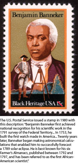
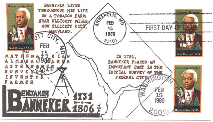
References
- Arnebeck, Bob (1991). Through a Fiery Trial: Building Washington, 1790–1800. Lanham, Maryland: Madison Books. Distributed by National Network. ISBN 0-8191-7832-2. OCLC 22006328. Retrieved 2015-04-24.
- Bedini, Silvio A. (1964), "Benjamin Banneker", Early American Scientific Instruments and Their Makers, United States National Museum Bulletin 231, Washington, D.C.: Smithsonian Institution Museum of History and Technology, pp. 22–25, OCLC 999972. At Internet Archive.
- Bedini, Silvio A. (1970). "Benjamin Banneker and the Survey of the District of Columbia, 1791" (PDF). Records of the Columbia Historical Society. 47: 7–30. OCLC 3860814. Archived from the original (PDF) on 2013-03-22. Retrieved 2013-01-13. At boundarystones.org
- Bedini, Silvio A. (1971). The Life of Benjamin Banneker. New York: Scribner (copyright 1972). ISBN 0-684-12574-9. OCLC 241422. Retrieved 2015-04-24.
- Bedini, Silvio A. (Spring–Summer 1991). "The Survey of the Federal Territory: Andrew Ellicott and Benjamin Banneker". Washington History. Washington, D.C.: Historical Society of Washington, D.C. 3 (1): 76–95. JSTOR 40072968.
- Bedini, Silvio A. (1999). The Life of Benjamin Banneker: The First African-American Man of Science (2nd ed.). Baltimore: Maryland Historical Society. ISBN 0-938420-59-3. OCLC 39024784. Retrieved 2015-04-24.
- Murdock, Gail T. (November 11, 2002). "Benjamin Banneker – the man and the myths". Customer review of Bedini, Silvio A. (1999). "The Life of Benjamin Banneker: The First African-American Man of Science", 2nd ed., Baltimore: Maryland Historical Society. Amazon.com. Archived from the original on 2013-07-08. Retrieved 2015-11-14.
- Toscano, Patrick (March 2000). "Book review of Bedini, Silvio A. (1999), "The Life of Benjamin Banneker: The First African-American Man of Science", 2nd ed., Baltimore: Maryland Historical Society". Professional Surveyor Magazine. Frederick, MD: Flatdog Media, Inc. 20 (3). Archived from the original on 2014-04-26. Retrieved 2015-11-14.
- Bedini, Silvio A. (2008). "Benjamin Banneker". Complete Dictionary of Scientific Biography. Encyclopedia.com. Retrieved 2012-05-08.
- "Benjamin Banneker Time Line". Benjamin Banneker Historical Park & Museum, 300 Oella Avenue, Baltimore, MD 21228 in Explore Catonsville, MD, part of the ExploreMD.us network. Ellicott City Graphic Arts Network. May 2006. Archived from the original on 2013-07-08. Retrieved 2013-07-08.
- Bowling, Kenneth R. (1988). Creating the federal city, 1774–1800 : Potomac fever. Washington, D.C.: American Institute of Architects Press. OCLC 18068942. Retrieved 2015-04-24.
- Corrigan, Mary Beth (April 2003). "Benjamin Banneker: Fabled Genius Considered": Review of Cerami, Charles A. (2002), Benjamin Banneker: Surveyor, Astronomer, Publisher, Patriot, New York: John Wiley & Sons "H-Net Reviews in the Humanities & Social Sciences: H-Net Maryland". H-Net: Humanities & Social Sciences Online. MATRIX: The Center for Humane Arts, Letters and Social Sciences Online, Michigan State University. Archived from the original on 2012-09-05. Retrieved 2013-07-08.
- Crew, Harvey W., Webb, William Bensing, Wooldridge, John (1892). IV. "Permanent Capital Site Selected". Centennial History of the City of Washington, D.C. Dayton, Ohio: United Brethren Publishing House. p. 87. OCLC 2843595. Retrieved 2009-05-07.
- Jusserand, Jean Jules (1916). "Major L'Enfant and the Federal City". With Americans of Past and Present Days. New York: Charles Scribner's Sons. pp. 137–195. OCLC 1075914. Retrieved 2011-08-15.
- Latrobe, John H. B., Esq. (1845). Memoir of Benjamin Banneker: Read before the Maryland Historical Society at the Monthly Meeting, May 1, 1845. Baltimore, Maryland: Printed by John D. Toy. OCLC 568468091. Retrieved 2014-08-29. At Google Books.
- Linklater, Andro (2007). The fabric of America: how our borders and boundaries shaped the country and forged our national identity. New York: Walker & Co. ISBN 0-8027-1533-8. OCLC 138533044.
- Phillips, P. Lee (1917). "The Negro, Benjamin Banneker; Astronomer and Mathematician, Plea for Universal Peace (Read before the Society, April 18, 1916)". Records of the Columbia Historical Society. Columbia Historical Society, Washington, D.C. 20: 114–120. ISSN 0897-9049. OCLC 1564221. Retrieved 2009-04-15. At Google Books.
- Stewart, John (1899). "Early Maps and Surveyors of the City of Washington, D.C.". Records of the Columbia Historical Society. Washington, D.C.: Columbia Historical Society. 2: 48–71. ISSN 0897-9049. OCLC 40326234. Retrieved 2011-08-15.
- Tindall, William (1914). Standard History of the City of Washington From a Study of the Original Sources. Knoxville, Tennessee: H. W. Crew and Company. OCLC 7059152. Retrieved 2013-01-31. At Google Books.
- Tyson, Martha Ellicott. A sketch of the life of Benjamin Banneker: from notes taken in 1836: read by J. Saurin Norris, before the Maryland Historical Society, October 5th, 1854. Baltimore, Maryland: Printed for the Maryland Historical Society by John D. Toy. Retrieved 2015-04-24. At Internet Archive and Open Library: eBooks and Texts.
External links
![]() Media related to Benjamin Banneker at Wikimedia Commons
Media related to Benjamin Banneker at Wikimedia Commons