Milford, Delaware
| City of Milford | |
| City | |
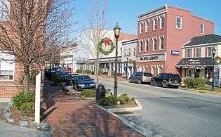 Walnut Street in Milford in 2006 | |
| Country | United States |
|---|---|
| State | Delaware |
| Counties | Kent and Sussex |
| Coordinates | 38°54′46″N 75°25′46″W / 38.91278°N 75.42944°WCoordinates: 38°54′46″N 75°25′46″W / 38.91278°N 75.42944°W |
| Area | 5.6 sq mi (14.5 km2) |
| - land | 5.6 sq mi (15 km2) |
| - water | 0.1 sq mi (0 km2) |
| Population | 9,559 (2010) |
| Density | 1,707/sq mi (659/km2) |
| Settled | 1680 |
| - Incorporated | February 5, 1807 |
| Mayor | Bryan Shupe |
| Timezone | EST (UTC-5) |
| - summer (DST) | EDT (UTC-4) |
| ZIP code | 19963 |
| Area code | 302 |
 Location in Kent County and the state of Delaware. | |
.svg.png) Location of Delaware in the United States | |
| Website: www.cityofmilford.com | |


Milford is a city in Kent and Sussex counties in the U.S. state of Delaware. According to the 2010 census, the population of the city is 9,559.[1]
The Kent County portion of Milford is part of the Dover, DE Metropolitan Statistical Area and the Philadelphia-Reading-Camden, PA-NJ-DE-MD Combined Statistical Area,[2] while the Sussex County portion is part of the Salisbury, MD-DE Metropolitan Statistical Area.
Geography
Milford is located at 38°54′46″N 75°25′46″W / 38.91278°N 75.42944°W (38.912840, −75.429327),[3] along the Mispillion River.[4]
According to the United States Census Bureau, the city has a total area of 5.6 square miles (15 km2), of which 5.6 square miles (15 km2) is land and 0.1 square miles (0.26 km2) (1.07%) is water.

History
The Kent County side of Milford was first settled in 1680 by Henry Bowan on what was known as the Saw Mill Range. A century later the Reverend Sydenham Thorne built a dam across the Mispillion River to generate power for his gristmill and sawmill. Around the same time, Joseph Oliver laid out the first city streets and plots nearby on a part of his plantation. Soon a number of homes and businesses appeared along Front Street. The city was incorporated February 5, 1807.[5]
In the 1770s, a ship building industry was already flourishing on the Mispillion River. Shipbuilding continued to be the major industry of Milford through World War I, bringing considerable prosperity to the town. The high point came in 1917 when the four-masted, 174-foot (53 m) long Albert F. Paul was launched from the William G. Abbott shipyard. At one point six shipyards were operating in the downtown area. When the last of the area’s giant white oaks was cut in the 1920s, the shipyards quickly went out of business, although the Mispillion ships sailed on for many years. (The Paul was sunk by a German torpedo in 1942 while sailing from the Bahamas.) The Vineyard shipyard was called into service in both World War I and II to build submarine chasers.[5]
During much of the twentieth century Milford served primarily as the commercial center for much of southern Delaware's large agricultural community.[5]
Seven of Delaware's governors have come from Milford: Daniel Rogers (who served 1797–99), Joseph Haslet (1811–14), William Tharp (1847–1851), Peter F. Causey (1855–59), William Burton (1859–63), William T. Watson (1895–97), and Ruth Ann Minner (2001–09).[5]
Abbott's Mill, Bank House, Carlisle House, Christ Church, Dr. Dawson House, Draper House, Egglinton Hall, Golden Mine, Grier House, Peter Lofland House, James McColley House, Milford New Century Club, Milford Railroad Station, Milford Shipyard Area Historic District, Mill House, Mispillion Lighthouse and Beacon Tower, North Milford Historic District, Old Fire House, Parson Thorne Mansion, South Milford Historic District Walnut Farm, Gov. William T. Watson Mansion, and J. H. Wilkerson & Son Brickworks are listed on the National Register of Historic Places.[6]
On Friday, May 30, 2003 at approximately 3:00 p.m. a fire started in a second floor apartment next to Wiley Hardware & Appliance on Walnut Street in the historic downtown section of Milford. More than 200 firefighters from Milford, Ellendale, Harrington, Felton, Dover, Smyrna, Houston, Frederica, Slaughter Beach, Bowers Beach, Greenwood, South Bowers, Farmington, Magnolia, Cheswold, Lewes, Georgetown, and Bridgeville in Delaware and Greensboro and Goldsboro in Maryland fought the blaze which destroyed seven businesses, a church, and three apartments, destroying an entire city block in the historic section of town. No one was killed in the blaze, but one civilian and six firefighters were injured.[7]
Demographics
| Historical population | |||
|---|---|---|---|
| Census | Pop. | %± | |
| 1860 | 1,178 | — | |
| 1870 | 1,150 | −2.4% | |
| 1880 | 1,240 | 7.8% | |
| 1890 | 2,555 | 106.0% | |
| 1900 | 2,500 | −2.2% | |
| 1910 | 2,603 | 4.1% | |
| 1920 | 2,703 | 3.8% | |
| 1930 | 3,719 | 37.6% | |
| 1940 | 4,214 | 13.3% | |
| 1950 | 5,179 | 22.9% | |
| 1960 | 5,795 | 11.9% | |
| 1970 | 5,314 | −8.3% | |
| 1980 | 5,366 | 1.0% | |
| 1990 | 6,040 | 12.6% | |
| 2000 | 6,732 | 11.5% | |
| 2010 | 9,559 | 42.0% | |
| Est. 2015 | 10,252 | [8] | 7.2% |
As of the census[10] of 2000, there were 6,732 people, 2,665 households, and 1,700 families residing in the city. The population density was 1,210.2 people per square mile (467.5/km²). There were 2,897 housing units at an average density of 520.8 per square mile (201.2/km²). The racial makeup of the city was 67.97% White, 23.26% African American, 0.34% Native American, 1.04% Asian, 0.16% Pacific Islander, 4.25% from other races, and 2.97% from two or more races. Hispanic or Latino of any race were 8.82% of the population.
There were 2,665 households out of which 32.6% had children under the age of 18 living with them, 42.6% were married couples living together, 16.8% had a female householder with no husband present, and 36.2% were non-families. 31.2% of all households were made up of individuals and 15.5% had someone living alone who was 65 years of age or older. The average household size was 2.44 and the average family size was 3.03.
In the city the population was spread out with 27.2% under the age of 18, 9.5% from 18 to 24, 27.3% from 25 to 44, 18.3% from 45 to 64, and 17.7% who were 65 years of age or older. The median age was 35 years. For every 100 females there were 86.6 males. For every 100 females age 18 and over, there were 80.1 males.
The median income for a household in the city was $32,525, and the median income for a family was $40,333. Males had a median income of $29,271 versus $23,164 for females. The per capita income for the city was $16,181. About 10.4% of families and 14.4% of the population were below the poverty line, including 21.1% of those under age 18 and 12.6% of those age 65 or over.
Education
Milford School District operates public schools.
Crime
The city of Milford has a crime rate higher than the national average in some categories, much higher in rape, assault, and theft, and lower in others.
| Milford | Nation | |
|---|---|---|
| Murder | 0.0 | 6.9 |
| Forcible Rape | 97.22 | 32.2 |
| Robbery | 166.7 | 195.4 |
| Aggravated Assault | 1333.3 | 340.1 |
| Burglary | 1027.8 | 814.5 |
| Larceny Theft | 5500.0 | 2734.7 |
| Vehicle Theft | 291.7 | 526.5 |
Formula used for chart: ((Crimes Reported) / (Population)) X 100,000)[11]
Notable people
- Mike Bagley, commentator for Motor Racing Network and co-host of The Morning Drive on Sirius XM NASCAR Radio.
- Jeff Baldwin, baseball player.
- Robert Crumb, a famous American cartoonist, lived in Milford for a few years and attended high school there.
- Simmie Knox began to teach himself to paint while living in Milford as a young man. He later became the first African-American to paint an official presidential portrait – that of President Bill Clinton.
- John Lofland (1798–1849), widely known as the "Milford Bard", was a prolific and widely read writer of prose, verse and speeches. He grew up and spent much of his life in "The Towers" on North West Front Street.
- Ruth Ann Minner, Governor of Delaware 2001–2009
- Harold Peterman, Delaware state legislator
- Chris Short, star baseball pitcher for the Philadelphia Phillies in the 1960s, was born in Milford.
- Alfred Thomas Archimedes Torbert, Union General in the civil war and diplomat.
References
- ↑ "The Delaware Census State Data Center". delaware.gov. Retrieved 1 September 2015.
- ↑ http://www.whitehouse.gov/sites/default/files/omb/bulletins/2013/b13-01.pdf
- ↑ "US Gazetteer files: 2010, 2000, and 1990". United States Census Bureau. 2011-02-12. Retrieved 2011-04-23.
- ↑ DeLorme (2004). Maryland Delaware Atlas & Gazetteer. p. 52. Yarmouth, Maine: DeLorme. ISBN 0-89933-279-X.
- 1 2 3 4 "History of Milford, Delaware". cityofmilford.com. Retrieved 2012-04-11.
- ↑ National Park Service (2010-07-09). "National Register Information System". National Register of Historic Places. National Park Service.
- ↑ "Fire Hits Block In Historic Milford, Delaware". Firehouse. Retrieved 1 September 2015.
- ↑ "Annual Estimates of the Resident Population for Incorporated Places: April 1, 2010 to July 1, 2015". Retrieved July 2, 2016.
- ↑ "Census of Population and Housing". Census.gov. Retrieved June 4, 2015.
- ↑ "American FactFinder". United States Census Bureau. Retrieved 2008-01-31.
- ↑ "Crime Rate Comparison - Compare US City Crime Rates".
External links
![]() Media related to Milford, Delaware at Wikimedia Commons
Media related to Milford, Delaware at Wikimedia Commons
Municipalities and communities of Kent County, Delaware, United States | ||
|---|---|---|
| Cities | ||
| Towns | ||
| CDPs | ||
| Unincorporated communities |
| |
| Hundreds | ||
| Footnotes | ‡This populated place also has portions in an adjacent county or counties | |
Dover (capital) | ||
| Topics |
|  |
| Society |
| |
| Cities | ||
| Towns |
| |
| Counties | ||
| Counties |  | |
|---|---|---|
| Principal city | ||
| Places 5k-20k | ||
| Places 1k-5k | ||