Layton, Florida
| Layton, Florida | |
|---|---|
| City | |
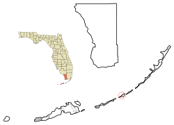 Location in Monroe County and the state of Florida | |
 U.S. Census Bureau map showing city limits | |
| Coordinates: 24°49′36″N 80°48′50″W / 24.82667°N 80.81389°WCoordinates: 24°49′36″N 80°48′50″W / 24.82667°N 80.81389°W | |
| Country |
|
| State |
|
| County | Monroe |
| Government | |
| • Mayor | Norman Anderson |
| Area | |
| • Total | 0.2 sq mi (0.7 km2) |
| • Land | 0.2 sq mi (0.6 km2) |
| • Water | 0 sq mi (0.1 km2) |
| Elevation | 0 ft (0 m) |
| Population (2000) | |
| • Total | 186 |
| • Density | 930/sq mi (265.7/km2) |
| Time zone | Eastern (EST) (UTC-5) |
| • Summer (DST) | EDT (UTC-4) |
| ZIP code | 33001 |
| Area code(s) | 305 |
| FIPS code | 12-39725[1] |
| GNIS feature ID | 0285408[2] |
Layton is a city on the island of Long Key in Monroe County, Florida, United States. The population was 186 at the 2000 census. As of 2004, the population estimated by the U.S. Census Bureau was 204.
History of Layton

In the late 19th century, Long Key was used as a coconut plantation. By 1910, Layton was becoming famous as a fishing destination, thanks in part to promotion by sports writer Zane Grey. However, the developing tourist infrastructure on Long Key was largely destroyed by the Labor Day Hurricane of 1935.
After World War II, Mary and Del Layton, who ran a grocery business in Miami, bought 40 acres (160,000 m2) on Long Key and started developing the property as "Layton's Long Key Fishing Camp", which grew substantially over the succeeding years.
Layton was incorporated as a town on September 18, 1963. The land that would become Long Key State Park was acquired between 1961 and 1973; the park opened on October 1, 1969.
Geography
Layton is located at 24°49′36″N 80°48′50″W / 24.826669°N 80.814006°W.[3]
According to the United States Census Bureau, the city has a total area of 0.2 square miles (0.52 km2). 0.2 square miles (0.52 km2) of it is land and 0.04 square miles (0.10 km2) of it (12.50%) is water.
Demographics
| Historical population | |||
|---|---|---|---|
| Census | Pop. | %± | |
| 1970 | 100 | — | |
| 1980 | 88 | −12.0% | |
| 1990 | 183 | 108.0% | |
| 2000 | 186 | 1.6% | |
| 2010 | 184 | −1.1% | |
| Est. 2015 | 190 | [4] | 3.3% |

As of the census[1] of 2000, there were 186 people, 84 households, and 50 families residing in the city. The population density was 860.0 inhabitants per square mile (326.4/km2). There were 165 housing units at an average density of 762.9 per square mile (289.6/km2). The racial makeup of the city was 98.92% White, 0.54% African American and 0.54% Asian. Hispanic or Latino of any race were 2.15% of the population.
There were 84 households out of which 15.5% had children under the age of 18 living with them, 56.0% were married couples living together, 1.2% had a female householder with no husband present, and 39.3% were non-families. 22.6% of all households were made up of individuals and 4.8% had someone living alone who was 65 years of age or older. The average household size was 2.21 and the average family size was 2.61.
In the city the population was spread out with 11.3% under the age of 18, 7.5% from 18 to 24, 23.1% from 25 to 44, 39.8% from 45 to 64, and 18.3% who were 65 years of age or older. The median age was 51 years. For every 100 females there were 95.8 males. For every 100 females age 18 and over, there were 98.8 males.
The median income for a household in the city was $53,750, and the median income for a family was $73,750. Males had a median income of $29,896 versus $23,125 for females. The per capita income for the city was $23,773. About 11.7% of families and 15.4% of the population were below the poverty line, including none of those under the age of eighteen and 21.4% of those sixty five or over.
Languages
As of 2000, English as a first language accounted for 90.68%, while Spanish as a mother tongue made up 9.31% of the population.[6]
References
- 1 2 "American FactFinder". United States Census Bureau. Retrieved 2008-01-31.
- ↑ "US Board on Geographic Names". United States Geological Survey. 2007-10-25. Retrieved 2008-01-31.
- ↑ "US Gazetteer files: 2010, 2000, and 1990". United States Census Bureau. 2011-02-12. Retrieved 2011-04-23.
- ↑ "Annual Estimates of the Resident Population for Incorporated Places: April 1, 2010 to July 1, 2015". Retrieved July 2, 2016.
- ↑ "Census of Population and Housing". Census.gov. Retrieved June 4, 2015.
- ↑ Modern Language Association Data Center Results of Layton, Florida
External links
Municipalities and communities of Monroe County, Florida, United States | ||
|---|---|---|
| Cities | 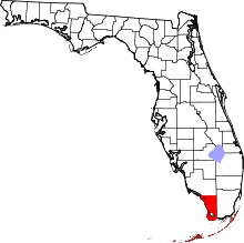 | |
| Village | ||
| CDPs | ||
| Unincorporated communities | ||
| Ghost towns | ||