Overseas Highway
| Overseas Highway | |
|---|---|
|
Overseas Highway traversing the Seven Mile Bridge | |
| Carries |
|
| Crosses | Gulf of Mexico, Florida Strait |
| Locale | Florida Keys |
| Maintained by | FDOT |
| Heritage status | NRHP (1979)[1] |
| Preceded by | Overseas Railroad |
| Characteristics | |
| Total length | 113 miles (182 km)[2][3] |
| Longest span | 6.79 miles (10.93 km)[4] |
| Clearance above | 65 feet (20 m) (at Moser Channel) |
| History | |
| Designer | Florida East Coast Railway; Overseas Highway & Toll Bridge Commission |
| Constructed by | Henry Flagler |
| Opened | March 29, 1938 |

The Overseas Highway is a 113-mile (181.9 km)[2][3] highway carrying U.S. Route 1 (US 1) through the Florida Keys. Large parts of it were built on the former right-of-way of the Overseas Railroad, the Key West Extension of the Florida East Coast Railway. Completed in 1912, the Overseas Railroad was heavily damaged and partially destroyed in the Labor Day Hurricane of 1935. The Florida East Coast Railway was financially unable to rebuild the destroyed sections, so the roadbed and remaining bridges were sold to the state of Florida for $640,000.
Since the 1950s the Overseas Highway has been refurbished into a main coastal highway between the cities of Miami and Key West, offering travelers an exotic roadway through a tropical savanna environment and access to the largest area of coral reefs on the U.S. mainland. Many exotic animals such as the American Crocodile and Key Deer inhabit the tropical islands of the Florida Keys.[5]
History
While the Overseas Highway today runs along the former Overseas Railroad right of way, portions of the highway came into existence earlier in a different alignment while the railroad was still operational. The concept of an Overseas Highway began with the Miami Motor Club in 1921. The Florida land boom of the 1920s was underway and the club wanted to attract tourists to easily reached fishing areas, which could only be reached by boat or train at the time. The land boom also attracted real estate interests who sought vehicular access to the upper keys where there were thousands of acres of undeveloped land. The completion of the railroad further proved a highway through the keys was feasible.[6]
Construction on the original Overseas Highway, designated State Road 4A (an extension of a route running from Miami to Homestead), lasted through most of the mid 1920s. Officially opening for traffic on January 25, 1928, the original highway existed in two segments at its greatest extent. One segment ran from the mainland via Card Sound Road to Key Largo and extended as far as Lower Matecumbe Key, while a segment in the lower keys existed from No Name Key to Key West. An automobile ferry service connected the 41 mile gap between Lower Matecumbe and No Name Keys.[6] State Road 4A mostly ran alongside of the Overseas Railroad in the upper keys but in the lower keys, it followed a much different path than the railroad and current highway. The ferry landing on No Name Key was located at the end of what is now Watson Boulevard, which carried State Road 4A across No Name Key and Big Pine Key before it crossed to Little Torch Key. On Little Torch Key, it turned south and rejoined the railroad. It would continue along the north side of the railroad to Upper Sugarloaf Key, where it turned south and ran along the current route of County Roads 939 and 939A over Lower Sugarloaf Key and the Saddlebunch Keys. From the Saddlebunch Keys, State Road 4A crossed onto Geiger Key, continuing along what is now Geiger Road and Boca Chica Road. On Boca Chica Key, it followed the shoreline south of Naval Air Station Key West's airstrip to Boca Chica Beach before crossing to Stock Island. On Stock Island, it followed Maloney Avenue and MacDonald Avenue where it rejoined the Overseas Railroad heading into Key West. Most of the State Road 4A bridges in the Lower Keys were of wooden construction and had been in use by the early 1920s.
By the early 1930s it was clear that the ferries were insufficient for the travel needs of the keys, and Monroe County and the State Road Department began making plans to connect the two portions of State Road 4A to make a continuous highway. By 1931, the ferries would also service a 13-mile road built through Marathon on the Vaca Keys with terminals at Hog and Grassy Keys. In 1933, the state legislature created the Overseas Road and Toll Bridge District to seek federal funding to extend the roadways. Funding was scarce as the country was in the midst of the Great Depression, but funding would eventually come through the Federal Emergency Relief Administration, part of President Franklin D. Roosevelt's New Deal. Hundreds of disgruntled World War I veterans seeking early payment of wartime bonuses were employed for construction on the roadway and bridges as part of a government relief program.[6]

Construction on a bridge connecting Lower Matecumbe Key and Long Key was already underway when the Category 5 Labor Day Hurricane struck Islamorada on September 2, 1935. The hurricane caused widespread damage throughout the area and destroyed much of the Overseas Railroad in the upper keys. Of the over 400 fatalities from the hurricane, more than half were veterans and their families. Their deaths caused anger and charges of mismanagement that led to a Congressional investigation. Just west of Lower Matecumbe Key at Mile Marker 73 on the current highway, eight concrete bridge piers and a small dredged island are all that remains of the veterans work. The dredged island is now known as Veteran's Key and the piers remain as a tribute to the veterans with a memorial plaque on Craig Key.[7]

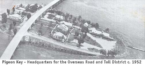
After the hurricane, the Florida East Coast Railway was financially unable to rebuild the damaged sections the Overseas Railroad. Seizing a rare opportunity, the state purchased the railroad's entire right of way and remaining infrastructure for a price of $640,000. The Overseas Road and Toll Bridge District abandoned its original highway plans and made new plans to build the highway on the old rail bed from Lower Matecumbe Key to Little Torch Key, effectively connecting the two segments of State Road 4A. The railroad's bridges, which withstood the hurricane and were in good condition, were retrofitted with new two-lane wide concrete surfaces for automobile use. In the case of the Bahia Honda Rail Bridge, which was a truss bridge, the concrete road surface was built on top of the trusses. The conversion of the railroad bridges to automobile use was accomplished by Cleary Brothers Construction Co. of West Palm Beach.[8] Portions of the road were tolled until April 15, 1954; toll booths were located on Big Pine Key and Lower Matecumbe Key. Pigeon Key, roughly the midway point of the Seven Mile Bridge, served as the headquarters for the "Overseas Road and Toll District."[9] The toll for automobiles was $1, plus 25 cents per passenger.[10] The full highway from the mainland to Key West was officially opened for traffic on March 29, 1938 and upon completion, the route became the southernmost segment of U.S. Highway 1, which previously terminated in Miami (State Road 4A would remain as a hidden designation until the 1945 Florida State Road renumbering, when the hidden designation became State Road 5).[11] President Franklin D. Roosevelt toured the road in 1939.

At this time, the Overseas Highway only ran along the old railroad route in the middle keys; the original highway segments were still in use in the upper and lower keys. As the United States entered into World War II, the U.S. Navy sought improvements to the highway to improve their access from the Naval Air Station on Boca Chica Key to the mainland for national security purposes. The 1920s-era lower keys segment was less than ideal with its winding road and rickety wooden bridges. This resulted in completing the rest of the highway throughout the keys on the former railroad right of way, which the state already owned and was a more direct route with smoother curves that would allow for higher speeds. Also included in this project was the construction of the highway from Florida City to Key Largo via Jewfish Creek (known as the 18-Mile Stretch). The new alignments, which were officially completed on May 16, 1944, shortened the route to the mainland by 17 miles.[12] The original Card Sound Bridge was closed after the Jewfish Creek alignment opened, and its remains were subsequently destroyed by a fire (the Card Sound route would be restored as a secondary route in 1969 with the opening of the current bridge). Today, some segments of the original highway remain as side and frontage roads for the current highway.
The original highway through Key Largo and Tavernier would once again become part of the Overseas Highway in the early 1970s when it was expanded to a four-lane divided highway, with the northbound lanes running along the route of the original highway and the southbound lanes along the route of the railroad.[6] The widening was the beginning of a much larger project to rebuild much of the Overseas Highway, which included replacing the aging repurposed railroad bridges with more modern bridges; some of which are able to accommodate more than two lanes of traffic. This included the Seven Mile Bridge, the Bahia Honda Bridge and the Long Key Bridge (although these three original bridges are no longer open to vehicular traffic, except for part of Seven Mile Bridge, they became listed on the National Register of Historic Places in 1979 and are currently used as fishing piers). The more modern bridges were completed in the early 1980s. In recent years, Pigeon Key was used by the University of Miami as an oceanography laboratory, but current efforts to restore the buildings on the island have resulted in the establishment of a railroad museum there. The newer Seven Mile Bridge does not have direct access to Pigeon Key; people going there must walk on 2.2 miles (3.5 km) of the original Seven Mile Bridge from its northern end on Knight's Key, or take a shuttle bus, to reach the island.
Mile markers
Locations along the Overseas Highway from Key West to Key Largo are commonly given as mile markers. The Florida Department of Transportation (FDOT) maintains mile marker signs every mile along the highway. Numbering starts in Key West, and increases towards the east and northeast up the path of the highway over the keys. Businesses along the highway began listing their locations by mile markers, adding decimal parts to more precisely indicate locations between mile marker signs. Outside of Key West and the city of Marathon, street addresses along the highway are based on the mile markers, using a four- to six-digit number (with no decimal point); the numbering pattern is as follows:[13]
- The first three (or four) digits denote the approximate mile marker; the first two (or three) digits denote the mile while the last digit denotes the nearest 0.1 (tenth of a mile)
- The last two digits denote a particular address; an even digit denotes an address on the Atlantic Ocean side while an odd digit denotes an address on the Florida Bay/Gulf of Mexico side
As an example, the Tropical Research Laboratory of Mote Marine Laboratory has a physical address of 24244 Overseas Highway. The first three digits indicate that it is near mile marker 24.2 (corresponding to an address on Summerland Key), while the last two digits indicate that it is located on the Atlantic Ocean side of the highway.
Trail
In 2001, the Monroe County Commission, the Florida Department of Environmental Protection's Office of Greenways and Trails, and FDOT entered into a Memorandum of understanding to create the Florida Keys Overseas Heritage Trail (FKOHT).[14] The trail will be a world-class, multi-use bicycle and pedestrian facility that will traverse the Florida Keys from Key Largo to Key West. Upon completion, the FKOHT will include an integrated system of educational kiosks, roadside picnic areas, scenic overlooks, fishing piers, water access points, and bicycle and jogging paths. The development of the trail will provide a mechanism for the preservation and use of the historic Flagler Railroad Bridges, 23 of which still exist and are mostly intact. Several alternatives exist for trail alignment, including cutting down the 22-foot-wide (6.7 m), 1940s-era roadway to its original 12-foot (3.7 m) spandrel width, or using the 22-foot-wide (6.7 m) roadway as is, particularly in multi-use areas. In all cases, original bridgework will be repaired or rebuilt, and the breaks created during the 1980s and 1990s fishing pier conversion will be reconnected. Where the original roadway no longer exists, the trail will be temporarily cantilevered on the side of the current US 1 highway bridge, until new 12-foot-wide (3.7 m) trail bridge sections can be built. The new sections will be built to match the historical character of the original bridges.
In popular culture
One of animated television's Wacky Races was The Overseas Hi-Way Race, which first aired on December 28, 1968, on CBS, covering the entire actual route from Key Largo to Key West. While Long Key was correctly portrayed, most of the other in-between keys were given fictional names, and Sombrero Key was actually five miles south of the highway in open water, according to the Florida Keys–East map.
The Overseas Highway is depicted in a screenprint by American artist Ralston Crawford.[15]
Major intersections
The entire route is in Monroe County.
| Location | mi[16] | km | Destinations | Notes | |
|---|---|---|---|---|---|
| Key West | 0.000 | 0.000 | Fleming Street | ||
| 0.406 | 0.653 | Truman Avenue / Whitehead Street | 90 degree turn | ||
| 0.490 | 0.789 | Duval Street | |||
| 1.337 | 2.152 | Eisenhower Drive / Jose Marti Drive | south end of four lanes | ||
| 1.643 | 2.644 | Palm Avenue / 1st Street | no left turn either way on US 1 | ||
| 3.927 | 6.320 | ||||
| 4.100– 4.169 | 6.598– 6.709 | Bridge over Cow Key Channel trail on sidewalk to north | |||
| Stock Island | 4.586 | 7.380 | MacDonald Drive | old SR 4A | |
| | 5.291 | 8.515 | Key Haven Boulevard | to Raccoon Key | |
| | 5.997– 6.498 | 9.651– 10.458 | Bridge over Boca Chica Channel | ||
| Boca Chica Key | 8.08 | 13.00 | Naval Air Station Key West | interchange | |
| Rockland Key | 8.790 | 14.146 | Toppino Industrial Drive | ||
| East Rockland Key | 9.183 | 14.779 | Rockland Drive - NAS Truck Entrance | former US 1 south | |
| | 9.508– 9.754 | 15.302– 15.698 | Bridge over Rockland Channel trail on old bridge to south | ||
| Big Coppitt Key | 10.691 | 17.205 | Boca Chica Road (CR 941 south) | ||
| | 11.181 | 17.994 | Shark Key | ||
| | 11.309– 11.701 | 18.200– 18.831 | Bridge over Shark Channel trail on old bridge to south | ||
| Saddle Bunch Keys | 12.547– 12.712 | 20.192– 20.458 | Bridge over Saddle Bunch No. 5 trail on old bridge to south | ||
| 13.018– 13.185 | 20.950– 21.219 | Bridge over Saddle Bunch No. 4 trail on old bridge to south | |||
| 14.118– 14.259 | 22.721– 22.948 | Bridge over Saddle Bunch No. 3 trail on old bridge to south | |||
| 14.328 | 23.059 | Blue Water Drive | |||
| 14.496– 14.616 | 23.329– 23.522 | Bridge over Saddle Bunch No. 2 trail on old bridge to south | |||
| 14.968 | 24.089 | East Circle Drive | |||
| 15.261– 15.504 | 24.560– 24.951 | Bridge over Lower Sugarloaf Channel trail on old bridge to south | |||
| | 16.370– 16.455 | 26.345– 26.482 | Bridge over Harris Channel | ||
| Lower Sugarloaf Key | 16.955 | 27.286 | Sugarloaf Boulevard (CR 939 south) | ||
| | 17.451– 17.472 | 28.085– 28.118 | Bridge over Harris Gap Channel | ||
| | 17.658– 17.741 | 28.418– 28.551 | Bridge over North Harris Channel | ||
| Park Key | 18 | 29 | no major intersections | ||
| | 18.600– 18.755 | 29.934– 30.183 | Bridge over Park Channel trail on old bridge to south | ||
| Sugarloaf Key | 19.349 | 31.139 | Crane Boulevard | ||
| 19.970 | 32.139 | State Road 939B (CR 939 south) | old SR 4A | ||
| | 20.150– 20.433 | 32.428– 32.884 | Bridge over Bow Channel trail on old bridge to south | ||
| Cudjoe Key | 21.409 | 34.454 | Blimp Road | ||
| | 23.471– 23.682 | 37.773– 38.112 | Bridge over Kemp's Channel partial old bridge to south | ||
| Summerland Key | 25.197 | 40.551 | East Shore Drive (CR 942 south) | ||
| | 25.413– 26.278 | 40.898– 42.290 | Bridge over Nile's Channel partial old bridge to south | ||
| Ramrod Key | 27.264 | 43.877 | Indies Road | ||
| | 27.504– 27.629 | 44.263– 44.465 | Bridge over Torch Ramrod Channel | ||
| Middle Torch Key | 27.836 | 44.798 | Middle Torch Road - Big Torch Key | ||
| | 27.895– 28.052 | 44.893– 45.145 | Bridge over Torch Key Channel | ||
| Little Torch Key | 28.216 | 45.409 | State Road 4A | old SR 4A | |
| | 28.625– 28.801 | 46.067– 46.351 | Bridge over South Pine Channel partial old bridge to south | ||
| | 29.411– 29.552 | 47.332– 47.559 | Bridge over North Pine Channel | ||
| Big Pine Key | 30.527 | 49.128 | Key Deer Boulevard (CR 940 north) - National Key Deer Visitor Center | ||
| | 33.130– 33.791 | 53.318– 54.381 | Bridge over Spanish Harbor Channel | ||
| Scout Key | 34.5 | 55.5 | no major intersections | ||
| | 35.272– 36.544 | 56.765– 58.812 | Bahia Honda Bridge over Bahia Honda Channel partial old Bahia Honda Rail Bridge to south | ||
| Bahia Honda Key | 36.794 | 59.214 | Bahia Honda State Park | ||
| | 38.361– 38.571 | 61.736– 62.074 | Bridge over Ohio Bahia Honda Channel trail on old bridge to north | ||
| Ohio Key | 38.75 | 62.36 | no major intersections | ||
| | 38.896– 39.176 | 62.597– 63.048 | Bridge over Missouri Ohio Channel trail on old bridge to north | ||
| Missouri Key | 39.25 | 63.17 | no major intersections | ||
| | 39.448– 39.620 | 63.485– 63.762 | Bridge over Little Duck Missouri Channel trail on old bridge to north | ||
| Little Duck Key | 39.823 | 64.089 | Veterans Memorial Park | ||
| | 40.011– 46.804 | 64.391– 75.324 | Seven Mile Bridge over Moser Channel partial old bridge via Pigeon Key to north | ||
| Marathon | 47.186 | 75.939 | Knights Key | ||
| Marathon (Vaca Key) | 48.059 | 77.343 | |||
| 49.965 | 80.411 | Sombrero Beach Road (CR 931 south) - Sombrero Beach | |||
| Marathon | 53.001– 53.081 | 85.297– 85.426 | Bridge over Vaca Cut trail on sidewalk to north | ||
| Marathon (Fat Deer Key) | 53.610 | 86.277 | Sadowski Causeway - Key Colony Beach | ||
| Marathon (Long Point Key) | 56.191 | 90.431 | Curry Hammock State Park | ||
| Marathon (Crawl Key) | 56.459 | 90.862 | Banana Boulevard | ||
| Marathon (Grassy Key) | 57.594 | 92.689 | Kyle Avenue | ||
| | 60.498– 60.786 | 97.362– 97.826 | Bridge over Tom's Harbor No. 4 trail on old bridge to south | ||
| Duck Key | 61.051 | 98.252 | Hawks Cay | ||
| | 61.418– 61.680 | 98.843– 99.264 | Bridge over Tom's Harbor Cut trail on old bridge to south | ||
| Conch Key | 62.846 | 101.141 | North Conch Avenue | ||
| | 63.140– 65.446 | 101.614– 105.325 | Long Key Bridge over Long Key Channel trail on old bridge to south | ||
| Long Key | 67.404 | 108.476 | Long Key State Park | ||
| | 70.735– 71.670 | 113.837– 115.342 | Bridge over Channel No. 5 partial old bridge to north | ||
| Craig Key | 72 | 116 | no major intersections | ||
| Islamorada | 72.642– 73.000 | 116.906– 117.482 | Bridge over Channel No. 2 trail on old bridge to north | ||
| Islamorada (Lower Matecumbe Key) | 74.403 | 119.740 | Gulfview Drive | ||
| Islamorada | 77.531– 77.703 | 124.774– 125.051 | Bridge over Lignumvitae Channel | ||
| 77.966– 78.353 | 125.474– 126.097 | Bridge over Indian Key Channel | |||
| 79.177– 79.318 | 127.423– 127.650 | Bridge over Tea Table Channel | |||
| 79.708– 79.761 | 128.278– 128.363 | Bridge over Tea Table Relief | |||
| Islamorada (Upper Matecumbe Key) | 80.425 | 129.431 | Frontage Road | old SR 4A | |
| 83.509 | 134.395 | Frontage Road | old SR 4A | ||
| Islamorada | 83.879– 84.001 | 134.990– 135.187 | Bridge over Whale Harbor Channel | ||
| Islamorada (Windley Key) | 84.344 | 135.739 | old SR 4A | ||
| Islamorada | 85.578– 85.739 | 137.724– 137.984 | Snake Creek Bridge over Snake Creek | ||
| Islamorada (Plantation Key) | 90.513 | 145.667 | Plantation Avenue / Sunshine Boulevard / Bessie Road | ||
| | 90.895– 90.955 | 146.281– 146.378 | Bridge over Tavernier Creek Waterway | ||
| Tavernier | 91.485 | 147.231 | Ocean Boulevard | ||
| Key Largo | 103.430– 103.454 | 166.454– 166.493 | Bridge over Marvin D. Adams Waterway | ||
| 106.312 | 171.093 | ||||
| 1.000 mi = 1.609 km; 1.000 km = 0.621 mi | |||||
References
- ↑ National Park Service (January 23, 2007). "National Register Information System". National Register of Historic Places. National Park Service.
- 1 2 Logan, Walter (1983-01-30). "ACROSS 42 BRIDGES THROUGH FLORIDA'S KEYS". Florida: NYTimes.com. Retrieved 2015-07-19.
- 1 2 "Road Trip: Florida Keys - National Geographic". Travel.nationalgeographic.com. 1970-01-01. Retrieved 2015-07-19.
- ↑ "Seven Mile Bridge". Structurae.
- ↑ Marzyck, Marion E. "History and Background: The Overseas Highway". Web World Wonders. Florida State University. Archived from the original on May 1, 2008. Retrieved October 3, 2011.
- 1 2 3 4 History of Overseas Highway
- ↑ Wilkinson, Jerry. "The Bridge That Never Was". Keys Historeum. Retrieved 9 January 2015.
- ↑ Crestview, Florida, "To Build Highway", Okaloosa News-Journal, Friday 1 May 1942, Volume 28, Number 15, page 5.
- ↑ Pigeon Key—Headquarters for the Overseas Road and Toll District, c. 1952 (Photograph). Historical Preservation Society of the Upper Keys. Retrieved October 3, 2011.
- ↑ Wilkinson, Jerry. "History of the Overseas Highway". Historical Preservation Society of the Upper Keys. Retrieved October 3, 2011.
- ↑ Sanderson, Dale. "End of US highway 1". U.S. Ends. Retrieved 9 September 2015.
- ↑ Hopkins, Alice. "The Development of the Overseas Highway" (PDF). FIU Digital Collections. Florida International University. Retrieved 30 June 2015.
- ↑ Wilkinson, Jerry. "Mile Markers in the Florida Keys". Historical Preservation Society of the Upper Keys. Retrieved August 9, 2006.
- ↑ "Florida Keys Overseas Heritage Trail". Florida Keys Overseas Heritage Trail. Retrieved October 3, 2011.
- ↑ Overseas Highway Whitney Museum of American Art.
- ↑ FDOT straight line diagrams, accessed April 2014
External links
| Wikimedia Commons has media related to Overseas Highway. |
- Historic American Engineering Record (HAER) No. FL-2, "Seven Mile Bridge, Linking Florida Keys, Knight Key, Monroe County, FL"